On October 4, as Typhoon No. 11 Matmo was still moving at sea, the Philippine Meteorological Agency warned that a low pressure area outside the Philippine monitoring area (PAR) was likely to strengthen into a storm and enter the PAR early next week.
If it develops into a storm, the system will be named Quedan, becoming the 17th storm to enter the PAR in 2025 and the second in October.
According to an update from the Japan Meteorological Agency (JMA), there is a possibility that in the next 48 hours, this low pressure area (code 94W) is likely to strengthen into a tropical depression (it may strengthen earlier than initially expected). Environmental conditions are very favorable for low pressure 94W to continue to develop in the coming days.
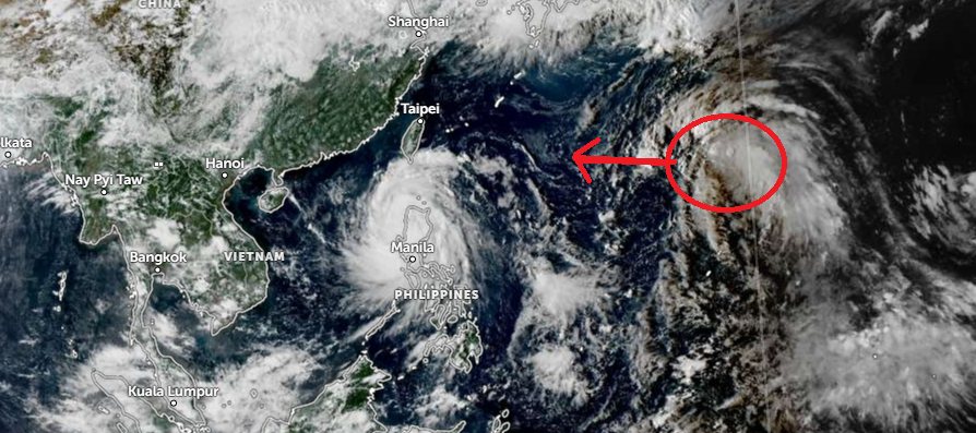
In addition to the low pressure, meteorologists have also recorded another severe weather zone forming off the Pacific Ocean. It is likely that in the coming days, a new tropical depression will appear, increasing pressure on the Southeast Asian region.
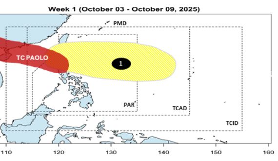
The JMA's forecast is in line with the forecast of the Philippine Atmospheric, Geophysical and Astronomical Services Administration (PAGASA).
In the 2-week storm forecast bulletin, PAGASA said that during the week of October 3-9, in addition to storm Paolo ( Matmo), a low pressure area appeared inside the PAR, moving towards Northern Luzon, with the possibility of the low strengthening into a storm.
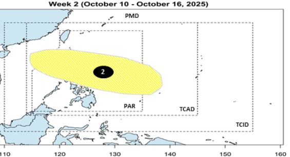
During the week of October 10-16, another low pressure will also appear in the PAR, expected to pass through Visayas and Luzon.
Forecast models still show unexpected changes that may occur in the development of these weather systems. Meteorological agencies recommend that people continue to closely monitor weather forecasts.
From the beginning of this year to October 4, there have been 11 storms in the East Sea - a storm season considered as unusually strong activities and extremely severe developments in the East Sea and mainland Vietnam.
According to the Typhoon page on the Northwest Pacific, the number of storms in the East Sea area accounts for 52% of the total number of storms in the entire Northwest Pacific area (11 out of a total of 21), while the average of many years fluctuates about 40%. The number of high-intensity storms accounts for 9/11 storms.
For the first time in the East Sea, a super typhoon with an intensity of level 17 appeared, gusting above level 17 with the lowest recorded pressure of 905mbar - super typhoon Ragasa (typhoon No. 9). According to the pressure calculation, super typhoon Ragasa has overcome super typhoon Yagi in 2024.
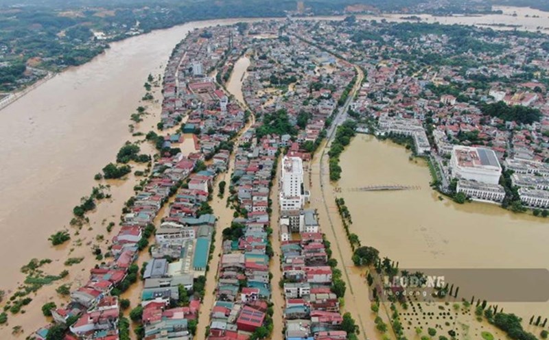
Storm No. 10 Bualoi is a storm with severe devastation for Vietnam. As of 6:00 a.m. on October 3, 2025, the provinces had 51 deaths, 14 missing people, and 164 injured people; 349 houses collapsed and collapsed; 172,104 houses had their roofs blown off and damaged; 88,999 hectares of rice and crops were damaged, 17,002 hectares of seafood were flooded and damaged; many traffic infrastructure works, irrigation works, dykes, production and business establishments, etc. were severely damaged. The total preliminary economic damage in some provinces is VND 15,864 billion.
The 2025 storm season in the East Sea will continue in October, November, and December.