Forecast of the time when the low pressure near the East Sea will strengthen into storm No. 11

Khánh Minh |

The low pressure in the eastern Philippines is forecast to strengthen into a storm, enter the East Sea and become the 11th storm.

The latest storm information from the Philippine Atmospheric, Geophysical and Astronomical Services Administration (PAGASA) said that at 2:00 p.m. on September 30, the center of low pressure 09g was at about 14.2 degrees north latitude, 135.8 degrees east longitude, 1,255 km east of southeast Luzon.

PAGASA forecasts that the low pressure is likely to strengthen into a tropical depression/storm at an average level in the next 24 hours or as early as the afternoon of October 1. The storm will then be locally named Paolo, the 16th storm in the Philippines this year and the first in October.

Typhoon Paolo is forecast to move north of Luzon on October 4-5. PAGASA urges people to continue monitoring updates on this potential tropical storm as the forecast is still subject to change.

Vi tri tam ap thap 09g hoi 14h ngay 30.9. Anh: PAGASA
Location of the center of low pressure 09g at 2:00 p.m. on September 30. Photo: PAGASA

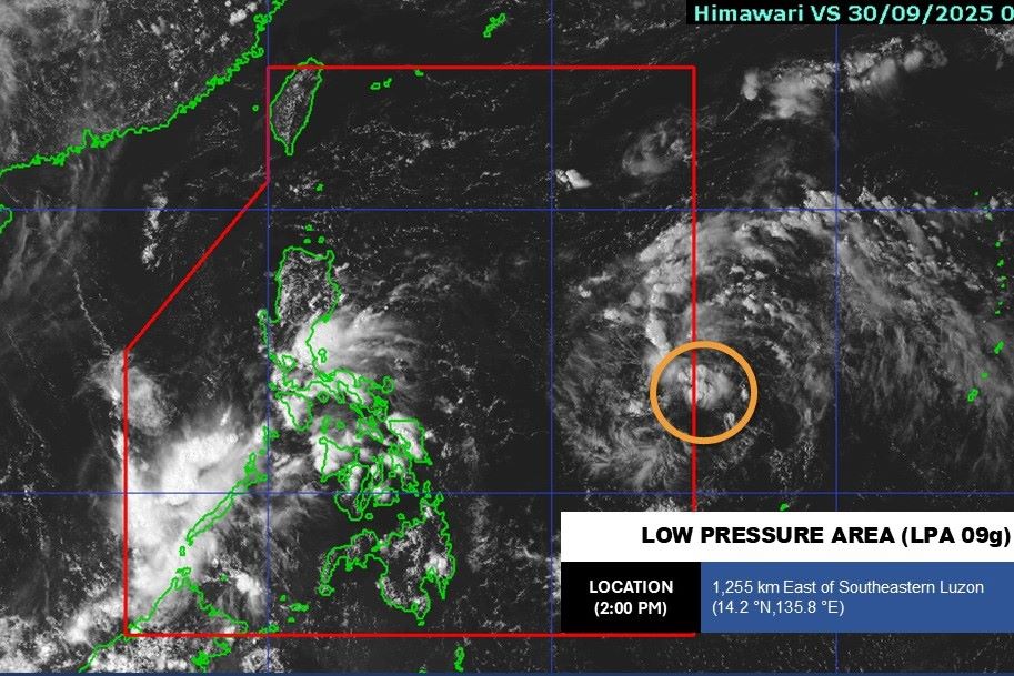
Meanwhile, the US Joint Typhoon Warning Center (JTWC) named the depression 93W. According to the latest forecast, low pressure 93W has been raised to an average level of the possibility of developing into a tropical depression/storm in the next 24 hours.

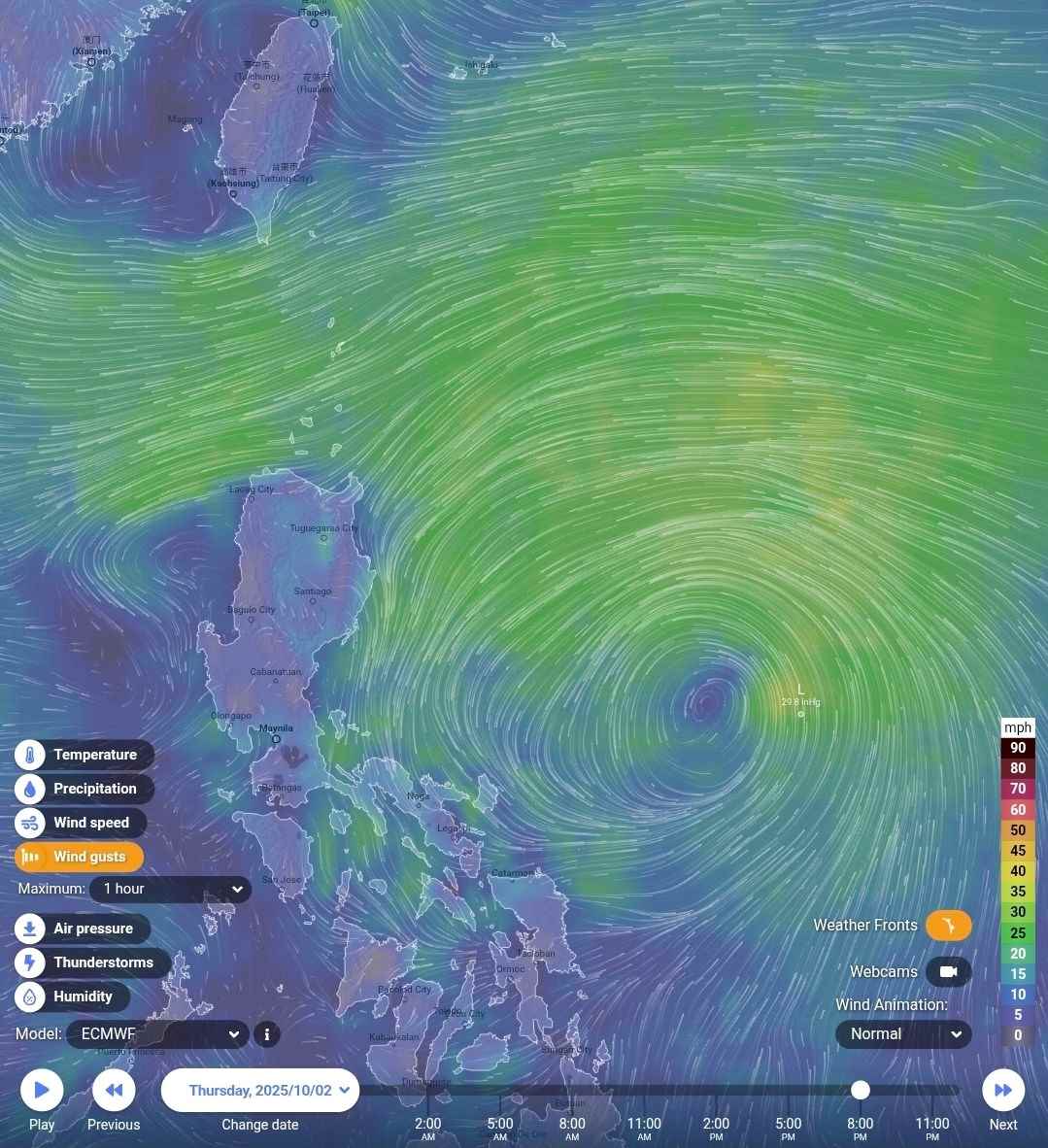
Satellite images show the formation bands surrounding the western edge of the wide low-level circulation, with strong movement in the southwest.

Proportive environmental conditions for the 93W low pressure area to continue to develop, sea surface temperatures are warm (28-30 degrees Celsius). The models show that the intensity of the low pressure area 93W will gradually increase in the west-northwest direction over the next 2 days.

According to the GFS and ECMWF storm forecast models, the low pressure is likely to strengthen into a storm and will enter the East Sea from October 4, becoming the 11th storm in 2025.

Du bao vi tri bao Paolo vao ngay 2.10. Anh: Philippine Daily Weather Update
Forecast of the location of storm Paolo on October 2 according to the ECMWF model. Photo: Philippine Daily Weather Update

PAGASA also forecasts that the southwest monsoon will weaken in the coming weeks, opening a transition period before the northeast monsoon officially overflows. This is a signal that the Philippines is about to enter a cooler and drier season.

According to weather forecaster Munir Baldomero, the determination of the end of the southwest monsoon season is based on many factors: Heavy rainfall in the west of the country has decreased significantly, the east and northeast winds have begun to dominate, while the southwest winds have clearly weakened. During the transition period, which typically lasts from the second half of October to early November, the easterly wind from the Pacific Ocean will dominate, before the northeast monsoon officially replaces it.

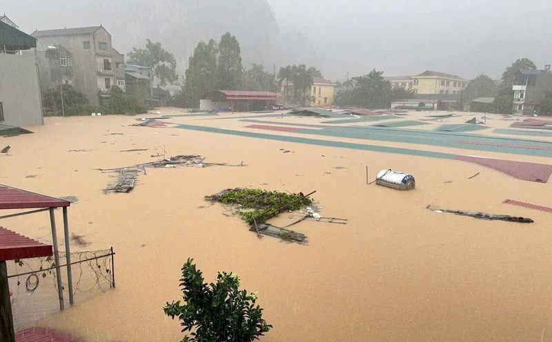
PAGASA also emphasized that although the southwest monsoon is weakening, people still need to be vigilant against unusual fluctuations in the weather, especially during the transitional season when storms often appear from the Pacific Ocean.

Although the northeast monsoon brings a pleasant cool air, the sudden change between the two monsoon systems can also cause heavy rain, thunderstorms or big waves in coastal areas.

Khánh Minh
RELATED NEWS

Cold air flows in, forecast of consecutive storms, serious flooding

|

The first cold spell of the season combined with consecutive storms caused the temperature to drop sharply in China and Vietnam.

Storm No. 10 has just passed, the seeds of storm No. 11 have appeared

|

Immediately after Typhoon No. 10 weakened, a new low pressure area appeared in the East of the Philippines with a high possibility of developing into Typhoon No. 11 in the East Sea.

Forecast of heavy storms near the East Sea in October, which may affect Vietnam

|

October storm forecast has 2-4 storms/tropical depressions in the Philippines, some of which may enter the East Sea, affecting Vietnam.

The water level of Bui and Tich rivers rose, Hanoi issued a level 2 flood warning

|

Hanoi - The impact of floods caused the water level of the Bui and Tich rivers to rise very quickly, the authorities have issued a second alert on these two rivers.

fastest access, search and rescue of missing people due to floods in Cao Bang, Tuyen Quang, Lao Cai

|

The Prime Minister requested the fastest implementation of access to landslides, flash floods, and search and rescue work for missing people due to floods.

Hanoi flooded heavily, people collapsed, vehicles stalled

|

Prolonged heavy rain caused many streets in Hanoi to be deeply flooded, people fell and stopped their vehicles in the middle of the road.

Identities of 3 officers constructing the Dong Dang - Tra Linh expressway swept away by flood

|

Cao Bang - 3 Dong Dang - Tra Linh construction officers were swept away by floodwaters and went missing.

Hanoi announces 65 flooded spots

|

Hanoi Hanoi Drainage One Member Co., Ltd. has just quickly announced about flooded areas in the city.

Cold air flows in, forecast of consecutive storms, serious flooding

Song Minh |

The first cold spell of the season combined with consecutive storms caused the temperature to drop sharply in China and Vietnam.

Storm No. 10 has just passed, the seeds of storm No. 11 have appeared

Song Minh |

Immediately after Typhoon No. 10 weakened, a new low pressure area appeared in the East of the Philippines with a high possibility of developing into Typhoon No. 11 in the East Sea.

Forecast of heavy storms near the East Sea in October, which may affect Vietnam

Khánh Minh |

October storm forecast has 2-4 storms/tropical depressions in the Philippines, some of which may enter the East Sea, affecting Vietnam.