The latest storm information from the Philippine Atmospheric, Geophysical and Astronomical Services Administration (PAGASA) on the morning of November 8 said that Typhoon Fung-wong currently has the strongest sustained winds of 130 km/h near the center of the storm and gusts of up to 160 km/h.
Typhoon Fung-wong has strengthened into a typhoon since 8:00 p.m. on November 7. The storm is 985 km from Eastern Visayas, Philippines, with the typhoon-force wind zone extending to more than 780 km from the center of the storm.
Typhoon Fung-wong is within the Philippine Forecast Area (PAR) and is moving west-northwest at a speed of 25 km/h.
In the updated storm bulletin on the morning of November 8, PAGASA forecasters said that Typhoon Fung-wong will move west-northwest until November 10 before turning north-northwest on November 11.
According to the forecast track, the center of Typhoon Fung-wong could make landfall in the southern part of Isabela or the northern part of Aurora Island on the night of November 9 or early morning of November 10.
After making landfall, Typhoon Fung-wong will pass through the mountainous terrain of Northern Luzon and enter the East Sea in the morning or afternoon of November 10, becoming Typhoon No. 14.
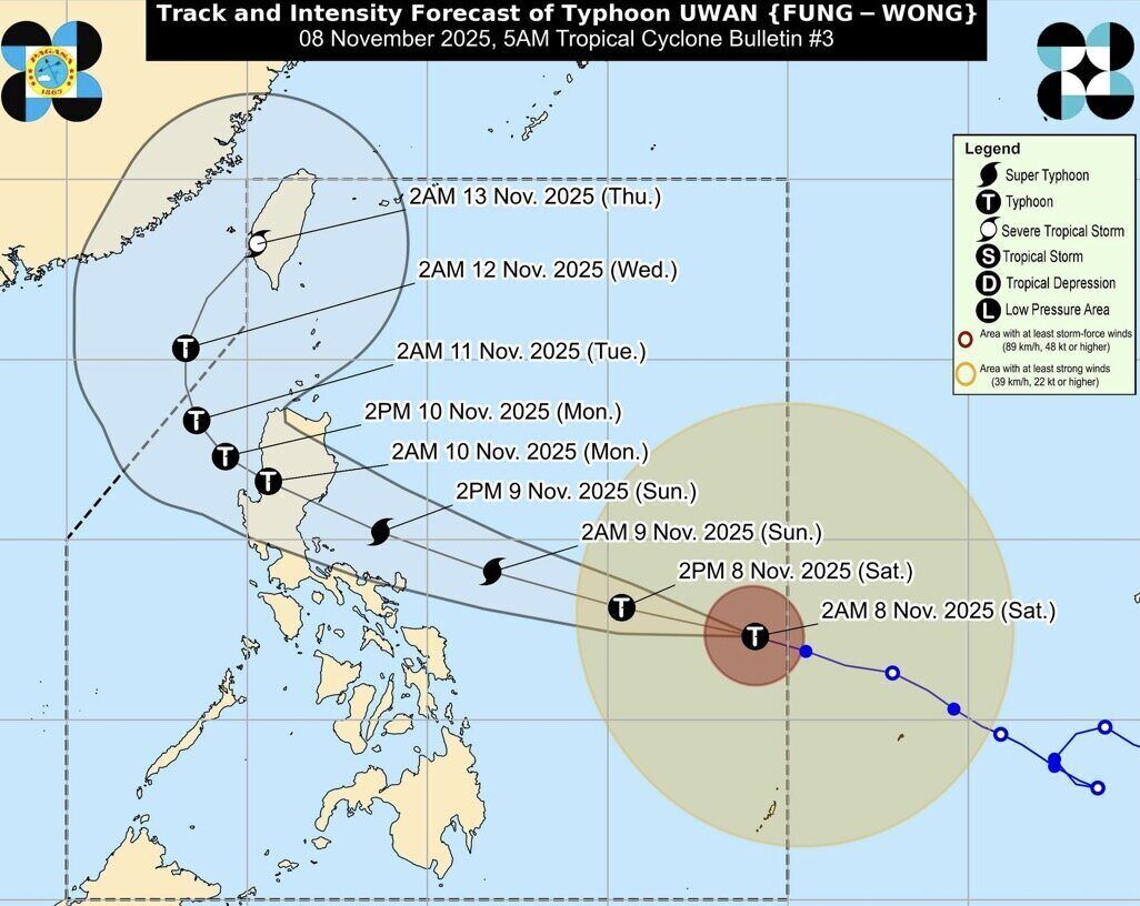
Weather experts in the Philippines warn that Fung-wong will rapidly strengthen and may reach super typhoon level on the night of November 8 or the morning of November 9. This storm near the East Sea could also make landfall in the Philippines at or near the poles.
Before entering the South China Sea, interaction with the terrain will weaken Typhoon Fung-wong, but it is expected to maintain typhoon status throughout the sweep of Northern Luzon and into the South China Sea.
PAGASA forecaster Chris Perez said most of the eastern Philippines will start to be affected by Fung-wong from the afternoon of November 8.
Scattered showers from the night of November 7 and some areas are warned of heavy rain from the afternoon of November 8 to the afternoon of November 9. In particular, Camarines Sur, Albay and Catanduanes provinces in the Bicol Region are all under red alert, meaning areas are forecast to see over 200mm of rain.
From the afternoon of November 9 to the afternoon of November 10, Mr. Perez said that rainfall will be concentrated in Northern Luzon and some provinces in Central Luzon, especially Aurora and Nueva Ecija. The remaining provinces in Central Luzon, along with Metro Manila and Calabarzon, will be warned of orange rainfall, from 50-100mm.
Although Typhoon Fung-wong is forecast to make landfall in Isabela or Aurora, the eastern provinces of Luzon should prepare for the potential typhoon's landfall scenario, as forecast models still show that the storm could deviate from its current path.
If the path of the super typhoon that preceded typhoon No. 14 moves south, it will place the Bicol region, especially Camarines Sur, Camarines Norte, Southern Luzon and even Metro Manila in the most affected area.
Meanwhile, as the path of Typhoon Fung-wong moves north, a potential super typhoon could hit northeastern Cagayan and northernmost Luzon.


