On September 19, Mr. Nguyen Tien Duan - Chairman of the People's Committee of Quang Khe commune (Dak G'long district, Dak Nong) confirmed that there were at least 3 landslides at the Cui Cho pass section of National Highway 28, passing through Quang Khe commune.
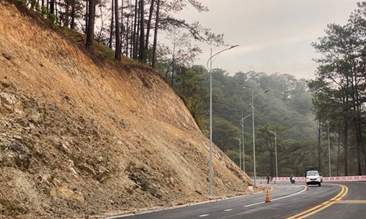
All three landslides are located on the positive slope of Highway 28. The landslides are about 1km apart on the Cui Cho Pass route.
The first point appeared on September 17 and is at risk of spreading. At the landslide points, many blocks of soil and forest trees have slid down the drainage ditch and part of the road surface. Currently, the functional sector has stretched ropes and put up danger warning signs at the landslide points.
After the incident, the People's Committee of Dak G'long district directed specialized departments and the People's Committee of Quang Khe commune to deploy measures to warn people and vehicles passing by of danger.
Cui Cho Pass is about 5km long, from Km182 - Km187 of National Highway 28). This pass is famous for being the most dangerous in Dak Nong province with a narrow road, many continuous sharp and dangerous turns.
On July 1, a sleeper bus carrying 47 people overturned and fell into a ravine at Cui Cho Pass. Fortunately, there were no casualties. The initial cause was determined to be the driver's unfamiliarity with the road and lack of attention.
National Highway 28 is the local traffic artery, connecting the center of Dak G'long district with Gia Nghia city and Lam Dong province.
Currently, Dak G’long is experiencing heavy rains. The work to fix the landslides has not been able to proceed yet. Local authorities are monitoring the weather and the landslides.
As soon as the weather is favorable, forces will deploy cleanup and implement solutions to ensure traffic safety at landslide sites.