Mr. Nguyen Thai Son - Head of the earthquake Monitoring Station of Dien Bien Phu City, Dien Bien Province (under the Institute of Geophysics) said: The earthquake occurred at 11:25:51 on May 16.
Immediately after the earthquake occurred, Dien Bien Phu City Seismic Monitoring Station sent seismic data to the Institute of Geophysics.
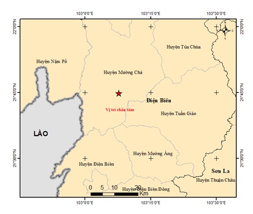
The results showed that the earthquake center was in Muong Cha district (Dien Bien province), with a magnitude of 5.0. The coordinates of the earthquake are 31,747 degrees North latitude - 103,129 degrees East longitude; the focal depth of the impact is about 10km.
Currently, the Institute of Geophysics assesses the level of natural disaster risk caused by earthquakes as level 2.
During the panic, many people in Dien Bien were still shocked.
Talking to a reporter from Lao Dong newspaper, Ms. Sung Thi Yen Nhi - Thanh Binh ward, Dien Bien Phu city said: "At that time, I was lying on the bed using my phone when I suddenly felt the shaking. Too scared, I ran out of the house. After that, I knew it was an earthquake."
In the past 100 years, the two biggest earthquakes in Vietnam have occurred in Dien Bien.
In 2015, a strong earthquake of 6.9 on the Richter scale, the center of which was located in the south of Dien Bien basin, and in 1983, a strong earthquake of 6.7 on the Richter scale, the center of which was in Tuan Giao district. Fortunately, both of the above earthquakes did not cause much damage because at that time there were not many modern construction works, mainly hills.


