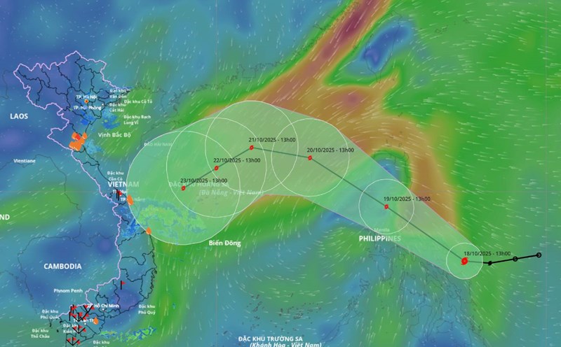
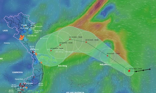
Updated from the National Center for Hydro-Meteorological Forecasting, at 7:00 a.m. on October 20, the center of the storm was at about 17.8 degrees north latitude - 116.9 degrees east longitude, about 490 km east-northeast of Hoang Sa Special Zone. The strongest wind near the storm center is level 9 (75-88 km/h), gusting to level 11. The storm is moving northwest at a speed of about 25 km/h.
It is forecasted that in the next 24 hours, the storm will move west-northwest at a speed of about 20 km/h and is likely to strengthen. At 7:00 a.m. on October 21, the center of the storm was at about 18.4 degrees north latitude - 112.7 degrees east longitude, in the northern East Sea, about 180 km north of the Hoang Sa special zone. Strong wind level 11, gust level 13.
The danger zone is from 15.5-20.5 degrees north latitude - 111-119 degrees east longitude. The natural disaster risk level is level 3 for the northern East Sea area (including Hoang Sa special zone).
It is forecasted that in the next 48 hours, the storm will move southwest at a speed of about 10 km/h. At 7:00 a.m. on October 22, the center of the storm was at about 17.2 degrees north latitude - 110.7 degrees east longitude, in the northwest sea of Hoang Sa special zone. Strong wind level 10-11, gust level 13.
The danger zone is from 15.0-20.5 degrees north latitude - 109.0-115 degrees east longitude. Level 3 natural disaster risk for the western sea area of the northern East Sea (including Hoang Sa special zone) and the sea area from Hue city to Quang Ngai.
It is forecasted that in the next 72 hours, the storm will move southwest at a speed of about 10 km/h and gradually weaken. At 7:00 a.m. on October 23, the center of the storm was at about 16 degrees north latitude - 108.6 degrees east longitude, in the coastal area from Hue city to Quang Ngai. Strong wind level 8, gust level 10.
The danger zone is from 14.5-19.0 degrees north latitude, west of 113.0 degrees east longitude. Level 3 natural disaster risk for the western sea area of the northern East Sea (including Hoang Sa special zone) and the sea area from Hue city to Quang Ngai.
It is forecasted that in the next 72 to 96 hours, the storm will move mainly southwest, traveling about 10 km/h and gradually weakening into a low pressure area.
Regarding the impact of the storm, the northern East Sea area (including Hoang Sa special zone) has strong winds of level 7-8, near the center of the storm level 9-11, gusts of level2; waves 3-5 m high, near the center of the storm 5-7 m high; the sea is very rough. All ships operating in the above dangerous areas are likely to be affected by thunderstorms, whirlwinds, strong winds and large waves.
On land, due to the influence of the storm circulation combined with cold air, winter wind disturbances and terrain effects, from October 22 to 27, the area from Ha Tinh to Quang Ngai is likely to experience widespread heavy rain, lasting for many days, locally very heavy rain.
There is a high risk of flash floods and landslides in mountainous areas, flooding in low-lying areas and urban areas. Localities need to pay attention to safe operation of hydroelectric and irrigation reservoirs before, during and after the storm; prepare response plans for flood scenarios on rivers from Quang Tri to Quang Ngai that are likely to reach alert level 3 and exceed alert level 3.