Forecast of very heavy rain in the next 3 days, some places exceed 450mm

AN AN |

From June 11 to 13, the Central Central region is likely to have widespread heavy rain; there is a risk of flooding, inundation, flash floods, and landslides.

This evening, June 10, the Ministry of Agriculture and Environment issued an official dispatch on proactively responding to heavy rain, the risk of floods, flash floods, and landslides in the Central, Central Highlands and Southern regions.

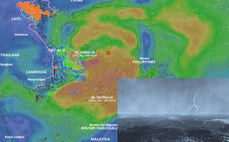
The document clearly stated that according to the bulletin of the National Center for Hydro-Meteorological Forecasting, from June 11 to June 13, the Central Central region (from Quang Binh to Quang Ngai) is likely to experience a period of moderate rain, heavy rain, locally very heavy rain with total rainfall ranging from 100 - 300mm, some places over 450mm.

The South Central, Central Highlands and Southern regions will have common rain from 30 - 150mm, locally over 200mm; locally heavy rain may appear over 200mm for 6 hours.

To proactively respond to heavy rain, the risk of floods, flash floods, and landslides, the Ministry of Agriculture and Environment recommends that provinces and cities continue to strictly implement the Prime Minister's Official Dispatch No. 76/CD - TTg dated May 28, 2025 on focusing on responding to the risk of heavy rain, landslides, flash floods and proactively preventing natural disasters in the coming time.

Closely monitor forecasts and warnings about heavy rain, floods, inundation, flash floods, landslides and provide timely and complete information to local authorities and people to proactively prevent them.

Deploy shock forces to inspect and review residential areas along rivers, streams, low-lying areas, areas at risk of floods, flash floods, and landslides to proactively clear the flow in areas with congestion and congestion; organize the relocation and evacuation of people to safe places.

In particular, organize forces to guard, control, support, and guide to ensure safe traffic for people and vehicles, especially at culverts, spillways, areas with deep flooding, fast-flowing water, areas where landslides have occurred or are at risk of landslides; resolutely not allowing people and vehicles to pass if safety is not guaranteed; prevent unfortunate damage to people due to carelessness and subjectivity; arrange forces, materials, and means to overcome incidents, ensure smooth traffic on main traffic routes when heavy rain occurs.

Check and review vulnerable works and unfinished works, including paying attention to dams, dykes, natural disaster prevention and control works; update response plans to ensure safety of works and downstream when floods occur.

Prepare a plan to ensure safety for rice, crops, and seafood; industrial parks, urban areas, residential areas, tourist areas along rivers, streams, and areas for tunnel and mineral exploitation. Prepare forces and means for rescue when required.

Direct local broadcasting and advertising agencies and mass media agencies to increase information about the developments of heavy rain to authorities at all levels, people, domestic and foreign tourists to proactively prevent in time.

At the same time, the on-duty staff should seriously and regularly report to the Ministry of Agriculture and Environment (through the Department of Dyke Management and Natural Disaster Prevention and Control).

AN AN
TIN LIÊN QUAN

Storm No. 1 is about to form and strengthen, affecting the mainland, causing heavy rain

|

According to the representative of the meteorological agency, the current tropical depression scenario is likely to strengthen into storm No. 1, which could cause heavy rain in the Central provinces.

Tropical depression is about to strengthen into storm No. 1, forecast affected areas

|

According to the representative of the meteorological agency, the tropical depression is likely to strengthen into storm No. 1 in the morning or afternoon of June 11.

Assessing the path scenario of the low pressure area when it strengthens into storm No. 1

|

According to the representative of the meteorological agency, the most likely scenario is that the low pressure area will enter the Hoang Sa archipelago of Vietnam after strengthening into a storm, then change direction to the north.

Storm No. 1 is about to strengthen, forecasting the most notable impact on the mainland of Vietnam

|

According to the representative of the meteorological agency, storm No. 1 Wutip will increase in intensity in the next 24 hours, affecting both the weather at sea and on land.

Mr. Lai Xuan Mon holds the position of Secretary of the Party Committee of the Central Propaganda and Mass Mobilization Commission

|

Mr. Lai Xuan Mon was appointed to hold the position of Secretary of the Party Committee of the Central Propaganda and Mass Mobilization Commission, term 2025 - 2030.

The Minister of Justice explained that the maximum fine for any field has not been increased

|

Minister of Justice Nguyen Hai Ninh said that increasing the maximum fine is a big issue that needs to be studied and carefully assessed for impact.

Unifying salary policy, assigning the education sector to recruit teachers

|

The National Assembly Standing Committee agreed on salary policy, support and attraction for teachers; assigned authority to the education sector to proactively recruit teachers, etc.

Government approves license of Sun PhuQuoc Airways airline

|

Deputy Prime Minister Tran Hong Ha has just given instructions on granting an air transport business license to Phu Quoc Sun Airlines Company Limited.

Storm No. 1 is about to form and strengthen, affecting the mainland, causing heavy rain

AN AN |

According to the representative of the meteorological agency, the current tropical depression scenario is likely to strengthen into storm No. 1, which could cause heavy rain in the Central provinces.

Tropical depression is about to strengthen into storm No. 1, forecast affected areas

LINH ANH |

According to the representative of the meteorological agency, the tropical depression is likely to strengthen into storm No. 1 in the morning or afternoon of June 11.

Assessing the path scenario of the low pressure area when it strengthens into storm No. 1

LINH ANH |

According to the representative of the meteorological agency, the most likely scenario is that the low pressure area will enter the Hoang Sa archipelago of Vietnam after strengthening into a storm, then change direction to the north.