The latest storm information from the Philippine Atmospheric, Geophysical and Astronomical Services Administration (PAGASA) at 2:00 p.m. on October 15, the center of low pressure area 10e was at about 12.0 degrees north latitude, 141.2 degrees east longitude, 1,715 km east of Eastern Visayas. The low pressure continues to show signs of strengthening and may develop into a tropical depression within the next 24 to 48 hours.
PAGASA weather forecaster Chenel Dominguez said that after strengthening into a tropical cyclone and entering the Philippine Forecast Area (PAR), the system will be locally named "Ramil".
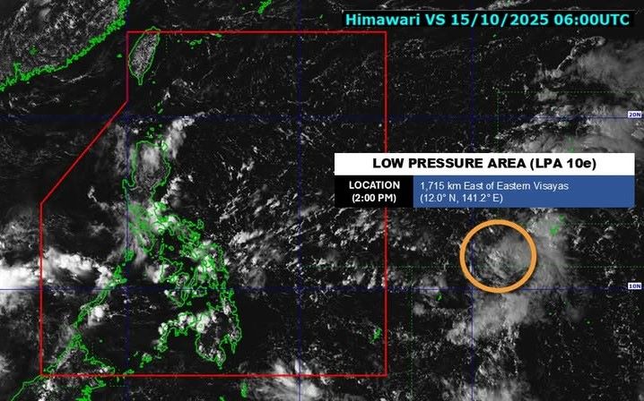
The potential storm could move closer to Northern Luzon and could bring widespread rain to Luzon over the weekend. However, Dominguez noted that the depression is still far from the Philippines and its forecast track may still change.
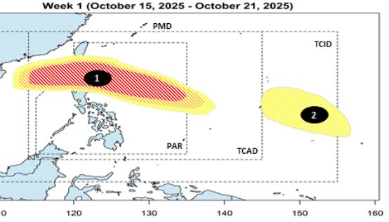
According to PAGASA's long-term storm forecast for 2 weeks, in the week of October 15-21, low pressure 1 (low pressure 10e) is forecast to have a high chance of strengthening into a storm, passing through Northern Luzon, leaving PAR and entering the East Sea, becoming storm No. 12. This week, another low pressure (low pressure 2) is likely to appear at the eastern edge of the Philippine TCID forecast area.
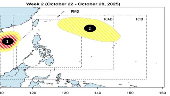
During the week of October 22-28, Typhoon No. 12 is forecast to head towards Hainan Island (China) and Vietnam. Meanwhile, low pressure 2 is moving northeast of the PAR, likely to strengthen at a low level.
Dominguez said PAGASA is closely monitoring the unusual weather situation and advised people to wait for further updated weather forecasts.
Meanwhile, winter winds and cold air will continue to affect the whole country in the next 24 hours.
Cloudy skies with scattered showers and thunderstorms are expected in Metro Manila, Calabarzon, Bicol Region, Eastern Visayas, Isabela, Aurora, Nueva Ecija, Bulacan, Marinduque, Oriental Mindoro, Romblon, Capiz, Aklan, Philippines and Bohol.
Batanes, Cagayan, Apayao and Ilocos Norte could also see scattered clouds and light rains due to the northeasterly wind flow.
Meanwhile, the rest of Luzon and the Visayas may experience cloudy skies with scattered showers or thunderstorms.
PAGASA recommends that people be vigilant against the risk of flash floods and landslides, especially during moderate to heavy rains or severe thunderstorms.