The latest storm news on the afternoon of October 13 from the Philippine Atmospheric, Geophysical and Astronomical Services Administration (PAGASA) said that a new storm is forecast to form near the Philippines from now until October 26.
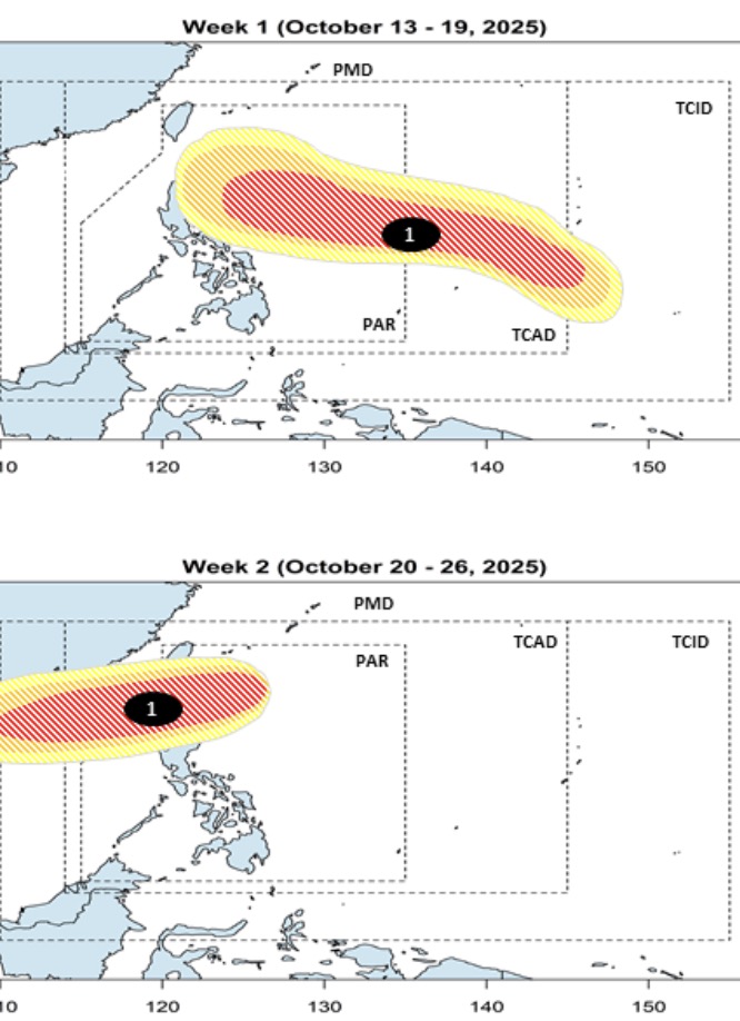
Forecasters in the Philippines point out that models show a new low pressure forming near the eastern boundary of the Philippine PAR and TCAD forecast areas during the week of October 13 to October 19. This low pressure is forecast to gradually move near Southern Luzon, Philippines during the forecast period with a high possibility of strengthening into a storm.
In the week from October 20 to October 26, according to forecast models, this storm will cross Northern Luzon, enter the East Sea, towards Vietnam and Hainan (China), and continue to maintain the intensity of the storm.
If it enters the East Sea, this storm will become storm No. 12. In the Philippines, when it enters PAR, the system will be locally named Ramil.
At 2:00 a.m. on October 13, the low pressure is likely to strengthen into storm No. 12 in the East Sea, which was determined by PAGASA forecasters to be 10e.
At that time, Depression 10e was about 2,540km southeast of Mindanao. Forecasters say 10e is unlikely to strengthen into a tropical depression in the next 24 hours.
PAGASA weather expert Daniel Villamil said the low pressure could enter the Philippine forecast area on October 16 or 17. "For at least the next four days, the weather system is not expected to have a significant impact," Villamil said.
However, by 8:00 a.m. on October 13, PAGASA detected that Depression 10e had advanced westward, 2,295 km from South Mindanao. At this time, Philippine forecasters said that the possibility of 10e becoming a tropical depression in the next 24 hours has reached the average level.
In the weather forecast on October 12, Ariel Rojas, a weather forecaster at ABS-CBN, Philippines, said that the low pressure could form in the southern island of Guam (USA) on October 13 and strengthen into a tropical depression on October 15.
Expert Ariel Rojas predicted that this system will enter the Philippine PAR forecast area late on October 17 or the morning of October 18 and will be named Ramil. However, he said that Typhoon Ramil will move northwest, towards Taiwan (China) early next week. The low pressure trough of Typhoon Ramil is expected to affect the weather in the Philippines, causing scattered showers and thunderstorms in the eastern and northern areas of Luzon.
According to the latest low pressure information from the US Navy's Joint Typhoon Warning Center (JTWC), the low pressure that the Philippines has identified as 10e is designated 96W by the JTWC. The new low pressure is south of Guam, in the western Pacific Ocean. The maximum sustained wind speed of the depression is about 25-35 km/h.
JTWC forecasters said the low pressure is unlikely to strengthen into a tropical depression in the next 24 hours. Satellite images show that this low pressure is a large, poorly organized system.
Global forecast models agree that 96W will develop northwest with increasing intensity over time. The forecast model of the European Center for Medium-Range Weather Forecasts (ECMWF) alone shows that 96W will not develop until it reaches the northern tip of Luzon Island, Philippines.