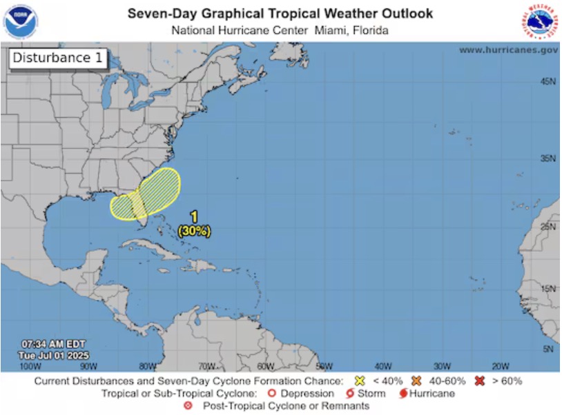
The latest hurricane information from the US National Hurricane Center (NHC) said that the center's hurricane forecasters have cordoned off the " area to watch" stretching from the northeastern Gulf of Mexico through Florida, with an estimated 30% chance of storm formation.
This year's Atlantic hurricane season begins slower than in previous years. Hurricane No. 1 Andrea briefly arrived on June 24, marking the latest start to the season since 2014.
Hurricane Barry then formed weakly in the Gulf of Mexico over the weekend but quickly weakened to a tropical depression before making landfall in Tamaulipas, Mexico on June 29.
Currently, it is forecasted that storm No. 3 may appear in the next few days. The next storm name for this year's storm season is Chantal.
It is not yet clear whether the storm will form in the Gulf of Mexico or east of Florida. The sea temperatures in the northeastern Gulf of Mexico are currently warm enough, ranging from 29 to 31 degrees Celsius, above average, creating favorable conditions for storm formation.
The possibility of a storm this week is a development of interest in the context of the US about to enter the National Day holiday on July 4.
In other related weather developments, a cold front will sweep across the Appalachian region of the Southeast and South Central United States, extending from Albany, New York to western Charlotte and the northwestern mountainous areas of Atlanta.
The area along and in front of the cold air masses often experiences atmospheric cyclones. The areas of tornadoes separated from the cold air mass as they moved through the warm ocean could trigger the formation of a low pressure.
This scenario usually occurs near the beginning and end of the typhoon season, i.e. in May, June, early July, or October and November.
If the areas of cold air mass move off the East Coast of the United States, they will encounter cooler ocean waters, reducing the likelihood of storm formation. However, there is still a possibility that this system will lead to the emergence of subtropical storm formation or similar systems.
Meanwhile, in the Pacific Ocean, the US National Hurricane Center said on July 1 that Flossie had strengthened into a Category 2 hurricane in western Mexico.
Flossie currently has maximum sustained winds of 175 km/h and is causing rain in some coastal areas of Mexico. The center of the storm is 320 km west-southwest of Manzanillo city. On the afternoon of July 1, Flossie approached the threshold of a Category 3 hurricane.
Forecasts show that Flossie continues to strengthen and may reach major typhoon level as early as July 2. According to the Saffir-Simpson classification scale, major storms are level 3 or higher, with minimum sustained winds of 180 km/h.
The Flossie is moving northwest at a speed of about 11 km/h and is expected to continue moving in this direction for the next few days. It is forecasted that from the night of July 2, Typhoon Flossie will begin to weaken.