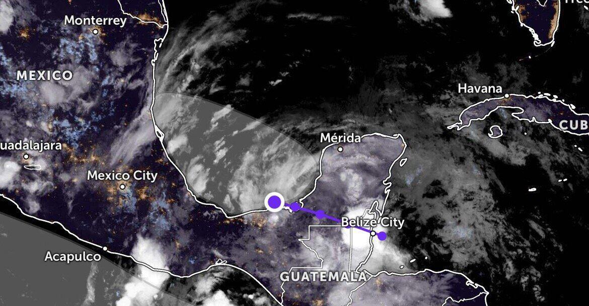
The latest storm and low pressure information from the US National Hurricane Center (NHC) said it is monitoring low pressure Invest 91L forming near Mexico's Yucatan Peninsula. This low pressure is being closely monitored due to the possibility of strengthening.
Invest 91L is expected to develop further as it moves through warm ocean waters, although current conditions are not favorable for the system to rapidly strengthen into a tropical depression or storm.
However, the low pressure developing near the Yucatan Peninsula is causing heavy rain in many areas of Central America, causing experts to issue warnings of the risk of flash floods and landslides.
The updated bulletin shows that Invest 91L is causing widespread showers and thunderstorms in the northeastern areas of Nicaragua, northern Honduras, Belize, Guatemala and southeastern Mexico. The rain is expected to continue.
Currently, storm forecast models predict a 40% chance that the system will develop into a tropical depression or tropical storm within the next 48 hours.
However, meteorological experts note that the development opportunities are very limited. Invest 91L is expected to make landfall in eastern Mexico on June 29, thereby likely ending the storm formation process.
Regardless of whether it strengthens into a typhoon or not, Invest 91L is still likely to cause localized heavy rains in Belize, Guatemala and southeastern Mexico from now until next week.
If it develops, the system could become a tropical depression. The chance of reaching typhoon status and being named is low, but not unlikely. Regardless of whether it forms or not, the system will still bring heavy rain, strong winds and flooding risks to Mexico and the extreme south of Texas (USA) from the end of this week to the beginning of next week" - FOX 35 weather forecaster Noah Bergren commented.
A US Air Force typhoon-hunting reconnaissance aircraft was scheduled to fly into the low pressure area on June 28 for study.
Currently, storm forecast models are still uncertain whether Invest 91L will develop into a tropical depression or a storm. Environmental conditions on the path of this depression are still hindering its development.
The next name on the 2025 Atlantic hurricane list is Barry, but there is currently no sign of a named storm in the near future.
For a long time, Campeche Bay has been a place where storms can rapidly intensify thanks to high sea surface temperatures and favorable terrain.
However, this year's Atlantic hurricane season is unusually quiet. The reason is believed to be due to higher-than-average surface pressure, dry air and unfavorable upper-level environments, affected by stronger typhoon activity in the Pacific.
The peak of the Atlantic hurricane season typically falls in mid-September, so the current few storms are not a sign reflecting the entire hurricane season this year, experts note.