3 consecutive low pressure areas near the East Sea in early July, risk affecting Vietnam

Thanh Hà |

It is expected that there will be 3 consecutive low pressure areas near the East Sea in the next 10 days, including one low pressure area that is likely to strengthen into a storm.

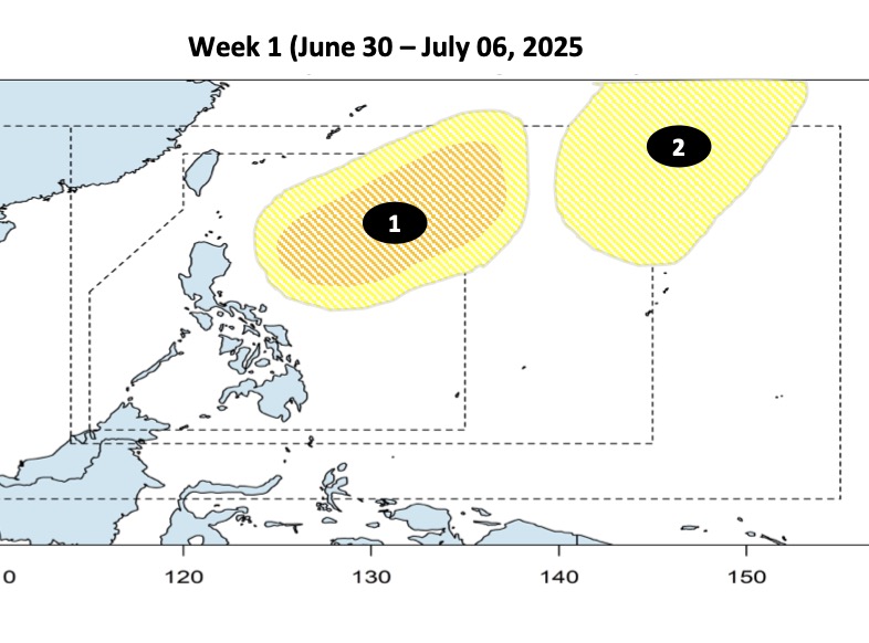
The latest storm and low pressure information from the Philippine Atmospheric, Geophysical and Astronomical Services Administration (PAGASA) on June 30 said that the two low pressure systems near the East Sea are expected to form one after another during the week from June 30 to July 6. The first low pressure is expected to appear in the Philippine Forecast Area (PAR). This low pressure is expected to strengthen into a low to moderate storm.

Also during the forecast period, a second low pressure is forecast to form at the northeastern boundary of PAGASA's TCAD forecast area, with less chance of strengthening into a storm than the first system.

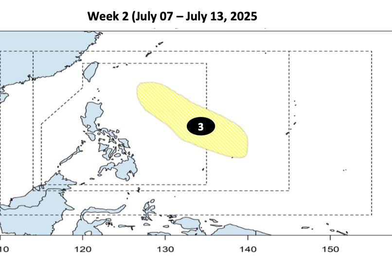
Another low pressure is expected to form between the eastern boundaries of TCAD and PAR between July 7 and July 13. This third depression is unlikely to strengthen into a storm during the forecast period.

According to PAGASA, the July typhoon near the Philippines usually has 3 main moving directions: First, the typhoon heads north of the PAR but does not make landfall in the Philippines but loops towards Taiwan (China) or Japan. Second, the typhoon makes landfall in the northernmost islands of the Philippines, then heads towards China or Hong Kong (China). Finally, the storm makes landfall in the area from the central to northern part of Luzon Island, Philippines, enters the East Sea and heads towards Vietnam.

Ap thap gan Bien Dong dau thang 7 co kha nang manh len thanh bao. Anh: PAGASA
The low pressure near the East Sea in early July is likely to strengthen into a storm. Photo: PAGASA

Previously, Philippine typhoon forecasters said that the country could record 11 to 19 typhoons between July and December 2025. Of which, July is expected to have 2 or 3 storms, August has 2 or 3 storms, September has 2 to 4 storms, October has 2 to 4 storms, November has 2 or 3 storms and December has 1 or 2 storms.

On average, 19 to 20 typhoons enter or form within the Philippine PAR forecast area each year, with eight to nine of them making landfall. PAGASA expert Joe Figuracion noted that storms that form in the coming months are more likely to make landfall.

Bao hinh thanh tu thang 7 co nhieu kha nang do bo vao dat lien hon so voi cac thang dau nam. Anh: PAGASA
Storms that form in July are more likely to make landfall than in the first months of the year. Photo: PAGASA

In late June, typhoon forecasters from the Taiwan Meteorological Administration (CWA) said the island was likely to be affected by 3-5 typhoons in the second half of 2025.

An average of 26.09 storms will form annually in the northwest Pacific and South China Sea from 1958 to 2024, with more than half occurring in July, August and September.

CWA Forecast Center Director Chen Yi-liang explained that in the past 3 months, the two most common paths of the typhoon have been: the path through Taiwan (China) and the Philippines and the path northward through the waters east of Taiwan (China). Whether these storms will have a direct impact on the island depends on the actual distance from Taiwan (China).

At the start of the 2025 hurricane season, only two storms will form in the northwest Pacific basin, below the historical average of 4.3 storms.

Thanh Hà
TIN LIÊN QUAN

Two storms appear at the same time, widespread storm and flood scene

|

The two tropical depressions off the coast of Mexico have strengthened, becoming tropical storms on June 29 and are forecast to continue to strengthen extremely strongly in the coming days.

Forecast of the possibility of a super typhoon appearing in July

|

The threat level of super typhoons in July may remain low, despite sea temperatures rising above average.

New low pressure causes widespread thunderstorms, likely to strengthen into storm Barry

|

Meteorological experts are monitoring a low pressure area that could strengthen into a storm near Mexico's Yucatan Peninsula.

Prime Minister appoints Lieutenant General Nguyen Van Hien to hold the position of Deputy Minister of National Defense

|

Lieutenant General Nguyen Van Hien was appointed by the Prime Minister to hold the position of Deputy Minister of National Defense.

Bich Tuyen said her billionaire husband was shocked and hurt when reading 15 pages of Dam Vinh Hung's oath

|

Singer Bich Tuyen said that before the lawsuit with Dam Vinh Hung, the two families loved each other very much, her daughter and the male singer's son often went out together.

US warns that many countries may increase tariffs

|

The current 10% tax rate applied by the US to imported goods from many countries may be raised after July 9.

Proposal to exempt construction permits for 112 projects in Ho Chi Minh City

|

HCMC - The Department of Construction has just proposed cutting construction licensing procedures for 112 projects eligible for exemption from construction permits in the area.

People are excited on the first day of administrative procedures in the new ward in Can Tho

|

Can Tho - With 8 transaction counters handling 260 procedures, the Ninh Kieu Ward Public Administration Service Center helps people process documents conveniently.

Two storms appear at the same time, widespread storm and flood scene

Thanh Hà |

The two tropical depressions off the coast of Mexico have strengthened, becoming tropical storms on June 29 and are forecast to continue to strengthen extremely strongly in the coming days.

Forecast of the possibility of a super typhoon appearing in July

Song Minh |

The threat level of super typhoons in July may remain low, despite sea temperatures rising above average.

New low pressure causes widespread thunderstorms, likely to strengthen into storm Barry

Thanh Hà |

Meteorological experts are monitoring a low pressure area that could strengthen into a storm near Mexico's Yucatan Peninsula.