
Latest storm and low pressure news on the morning of July 14 from the Philippine Atmospheric, Geophysical and Astronomical Services Administration (PAGASA) said that a new low pressure area in the East Sea has formed. The low pressure area named 07b by PAGASA is in the northern East Sea area, outside the Philippine Area of Responsibility (PAR).
Tropical depression 07b in the East Sea is about 820km east of the northernmost Luzon, Philippines. Philippine weather forecasters believe that 07b is likely to strengthen into a tropical depression in the next 24 hours.
Meanwhile, as of 8 am on July 14, Typhoon Haishen (Philippines name Josie) has weakened into a tropical depression. Haishen is located in the east of the Philippines and is in the PAR forecast area.
Previously, in the typhoon bulletin at 5 am on July 14, PAGASA said that Typhoon Haishen was 1,085km east of Eastern Visayas, Philippines. The typhoon moved at a speed of 25km/h, with maximum sustained winds of 65 km/h near the center and gusts up to 80 km/h. At that time, PAGASA's typhoon forecasters also determined that Haishen would gradually weaken into a tropical depression in the next 12 hours due to unfavorable weather conditions.
Haishen is expected to continue moving north until July 15, then shift to the northeast for the remaining forecast period. The storm is forecast to leave PAR on the evening of July 14 or morning of July 15.
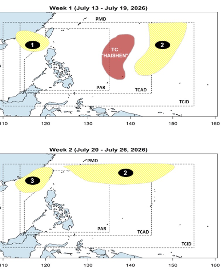
The appearance of a new low pressure area in the East Sea 07b is also consistent with the short-term forecast announced by PAGASA on July 12.
According to this forecast, as soon as Typhoon Haishen operates in the east of the Philippines, 2 new low pressures have continuously formed, of which the first low pressure formed in the north of the East Sea in the week from January 13-19. 7. This low pressure in the East Sea has a short duration of existence, a small affected area and is unlikely to strengthen into a storm or tropical depression.
Also in the forecast period from July 13-19, the 2nd low pressure, with a wider scope of influence, is likely to form in the east of PAGASA's PMD forecast area.
The second low pressure is likely to exist until the forecast period from July 20-26, with the main scope of activity in the northeast of PMD, with little chance of strengthening into a storm or tropical depression.
Also during this period, a 3rd low pressure area is likely to form in the East Sea, with a wider scope than the low pressure area formed from the previous week. This low pressure area in the East Sea is also unlikely to strengthen into a storm.


