
The latest typhoon and low pressure bulletin on the afternoon of July 16 from the Philippine Atmospheric, Geophysical and Astronomical Services Administration (PAGASA) said that low pressure near the Philippines 07c is about 2,915km northeast of Mindanao. This low pressure is outside the Philippine Area of Responsibility (PAR) and is highly likely to strengthen into a tropical depression in the next 24 hours. Previously, in the bulletin at 8 am on July 16, PAGASA said that no low pressure area is being monitored by this agency.
The appearance of low pressure 07c is consistent with the long-term forecast announced on June 16 by PAGASA, which said that there are 2 consecutive low pressures appearing near the Philippines in the second half of July.
In this latest storm forecast, Philippine forecasters pointed out that in the week from July 16-22, a low pressure area will form at the eastern boundary of PAGASA's TCID forecast area. This low pressure area is assessed to be likely to strengthen into a storm or a tropical depression at a low to medium level.
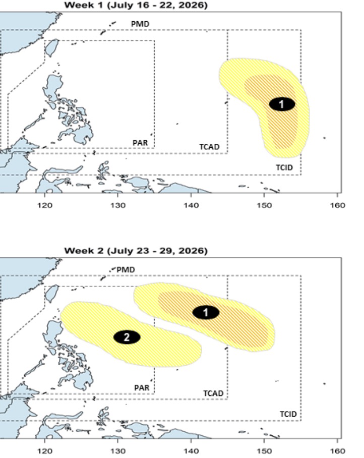
This low pressure area will continue to exist and move westward in the week from July 23-29. The system will move northeast of the TCAD and PAR forecast areas with the possibility of strengthening at a low to medium level.
Also in the forecast period from July 23-29, another low pressure area is likely to form in the eastern part of TCAD and is likely to enter PAR. The second low pressure area is less likely to strengthen into a storm or tropical depression when continuously moving northwest, near the Philippines.
Tropical depression near the Philippines 07c that PAGASA is monitoring is also being monitored by the US Navy's Joint Typhoon Warning Center (JTWC) and named 90W.
JTWC weather forecasters say that 90W is located in the western Pacific, with little chance of developing into a tropical storm in the next 24 hours. However, this low pressure has maximum sustained winds of about 35-45 km/h.
Analysis shows that low pressure 90W is in a favorable environment for development, with low wind gusts, good divergence at high altitudes and warm sea surface temperatures, from 29-30 degrees C. JTWC's forecast models all agree that 90W will continue to move in the north-northwest direction.


