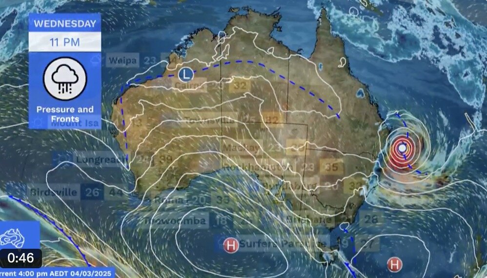
Weatherzone's latest storm report says Typhoon Alfred is moving southeast of Queensland as a Category 2 tropical storm. At 7:00 a.m. on March 5, Eastern Australia time, the storm was about 425km east of Brisbane. The storm is moving west at a speed of about 11km/h.
Satellite imagery on the morning of March 5 shows that Alfred does not resemble a typical tropical storm. The thick convective clouds that often surround the core of tropical cyclones do not appear at the center of storm Alfred. This shows that dry air and wind shear are penetrating the storm, preventing it from strengthening in the previous 24 hours.
However, forecasters say conditions are favorable for Alfred to intensify as it approaches the southeastern coast of Australia in the coming hours.
One of the main reasons forecasters believe that Alfred will strengthen as it approaches the coast is because the storm will move across the warm East Australian Ocean (EAC).
Tropical cyclones draw energy from warm ocean heat and need sea surface temperatures of 26.5 degrees Celsius or higher to accelerate.
Storm Alfred has just moved through the sea area with temperatures around 25-26 degrees Celsius. When moving west on March 5 and 6, the storm will pass through a warm strip of sea with surface temperatures around 27 degrees Celsius.
In addition to warm water providing more energy for Typhoon Alfred, a reduced vertical wind shear will also help strengthen Typhoon Alfred as it approaches land.
Typhoon Alfred is forecast to make landfall with strong winds of level 2, gusts of up to about 155 km/h near the center of the storm. There is a chance that Alfred will become a Category 3 storm before making landfall. A Category 3 storm has gusts of up to 165 km/h or more near the center of the storm.
Red import is now expected to cross the coast near or south of Brisbane overnight or on the morning of March 7. The strongest winds, heaviest rains and biggest waves are likely to hit near and south of the eye of Alfred when it makes landfall.
The latest storm news from ABC News shows that storm Alfred formed very unusually, appearing in the southern Pacific Ocean at the same time as two storms Rae and Seru.
The three storms formed from the same trough of pressure - a rare occurrence, especially in the southern Pacific. Rae is heading towards Fiji, causing damage to several islands before weakening, while Seru moves across the offshore waters of Vanuatu before dissipating.
"This phenomenon is happening very strongly across the male hemisphere, not just in the southern Pacific," said Liz Ritchie-Tyo, professor of atmospheric science at Monash University. Two storms have formed around Japan, on the other side of the southern Indian Ocean, so there are actually many events happening at the same time.
Most of the storms make landfall on the east coast of Australia at a fast and fast pace, but Alfred has a different approach, moving slowly parallel to the coast.
According to the latest announcement from the Australian Weather Service on the morning of March 5, Typhoon Alfred is moving west at a speed of 16 km/h. This has led to large areas of waves extending and spreading over the past few days. Due to the impact of the storm, nearly 1,000 km of Australia's east coast is under a coastal hazard warning, from Forster in New South Wales to Sandy Cape, near Bundaberg.