According to the latest storm information from the Philippine Atmospheric, Geophysical and Astronomical Services Administration (PAGASA) on the morning of November 7, the severe tropical storm Fung-wong continued to strengthen outside the country's storm monitoring area.
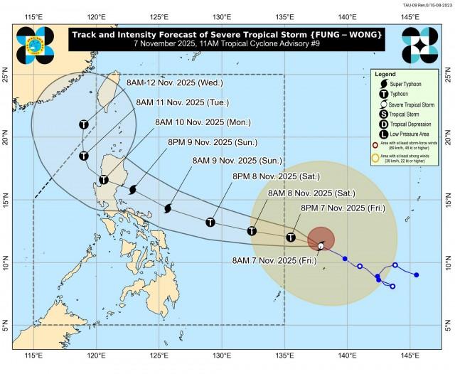
In its 11am bulletin, PAGASA said the center of Typhoon Fung-wong was located 1,315km east of Eastern Visayas. The strongest wind near the center of the storm has increased to 100 km/h, gusting up to 125 km/h. The storm is moving west-northwest at a speed of 20 km/h and the area affected by the storm's winds has expanded to a radius of up to 720 km from the center.
PAGASA forecasts that Typhoon Fung-wong will enter the Philippine monitoring area on the evening of November 7 or early morning of November 8 and will be locally named Uwan.
The most worrying thing is the intensity forecast. The agency warned that Typhoon Fung-wong could rapidly strengthen and reach typhoon level within the next 24 hours. More alarmingly, the storm is likely to reach super typhoon status on the evening of November 8 or the morning of November 9.
PAGASA's storm forecast shows that the storm is likely to make landfall directly in the southern area of Isabela province or the northern part of Aurora province (North Luzon) in the early morning of November 10. PAGASA said the most dangerous scenario is that the storm could make landfall when it is at its strongest intensity.
Due to the expected high intensity, PAGASA warned that the highest Typhoon Warning Signal (TCWS) that can be issued in the Philippines is level 5, the highest disaster warning level on the country's scale.
Life-threatening weather conditions are expected in Northern Luzon and parts of Central Luzon on November 10-11. The risk of storm surge and coastal flooding is also warned. The sea situation is extremely dangerous, with warnings that waves in coastal areas near the center of the storm could reach 9m.
After making landfall and sweeping across the mountainous terrain of Northern Luzon, the storm is forecast to enter the East Sea in the morning or afternoon of November 10.
The appearance of Fung-wong comes right after Typhoon No. 13 Kalmaegi swept through the central Philippines, causing flooding and forcing tens of thousands of people to evacuate. The warning of another potential super typhoon is in line with PAGASA's late October forecast, saying the area could see a few more storms due to the impact of La Nina.


