The latest storm information from the Philippine Atmospheric, Geophysical and Astronomical Services Administration (PAGASA) said that at 10:00 a.m. on November 5, the center of the tropical depression was at about 8.1 degrees north latitude; 143.3 degrees east longitude, 1,835 km east of Mindanao Island (Philippines).
The tropical depression is moving slowly westward at a speed of about 10 km/h, carrying strong winds of 55 km/h, gusts of 70 km/h, and air pressure of 1002 hPa.
PAGASA weather forecaster Benison Estareja said that the tropical depression has not yet directly affected the mainland, but the high temperatures in the Pacific Ocean could cause it to rapidly intensify over the next 48 hours, reaching typhoon or super typhoon status before entering the Philippine Forecast Area (PAR) on Saturday morning, November 8.
When entering PAR, the storm will be locally named Uwan. According to the forecast track, Typhoon Uwan will move west-northwest, towards Northern or Central Luzon, and is likely to make landfall in Cagayan or Aurora on Monday morning, November 10.
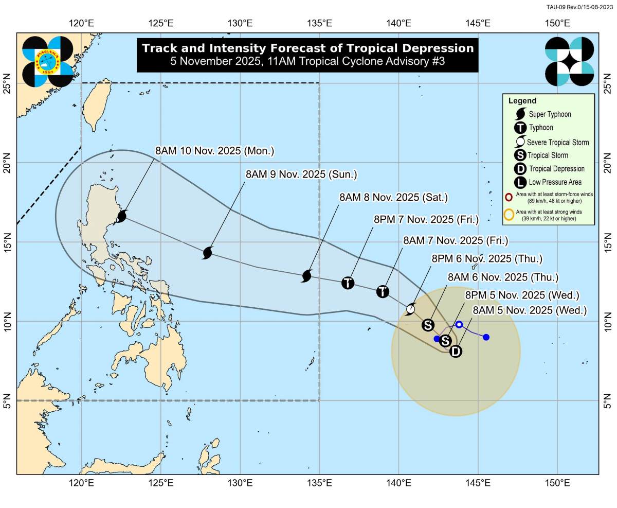
With the potential to reach super typhoon level, winds can reach 1855 km/h. The storm is forecast to change slightly to the north (Batanes) or south (Bicol region) depending on atmospheric conditions.
According to PAGASA, in the next 12-24 hours, the tropical depression may move quite erratically before stabilizing northwest from Thursday (November 6) and then moving deep west-northwest.
As the storm strengthens, thick clouds and strong winds will expand, affecting much of Luzon and Eastern Visayas from Sunday (November 9) to Tuesday (November 11).
PAGASA warned that the weather will start to get worse from Sunday (November 9), with heavy rain and life-threatening strong winds in Northern and Central Luzon in the first two days of next week. The risk of coastal rises, flooding and high waves is forecast to increase sharply along the east coast of Luzon, especially in the Cagayan, Isabela and Aurora regions.
Meanwhile, as of November 5, the death toll from Typhoon No. 13 Kalmaegi (local name Tino) in the Philippines has increased to more than 90 people, of which province of Philippines - the most severely affected - alone was 76.
According to the Vietnam National Center for Hydro-Meteorological Forecasting (NCHMF), at 2:00 p.m. on November 5, the center of storm No. 13 was at about 11.9 degrees north latitude; 117.4 degrees east longitude, about 340km east-northeast of Song Tu Tay Island (belonging to Truong Sa Special Zone). Maximum wind speed: level 13-14 (134-166 km/h), gust level 17.
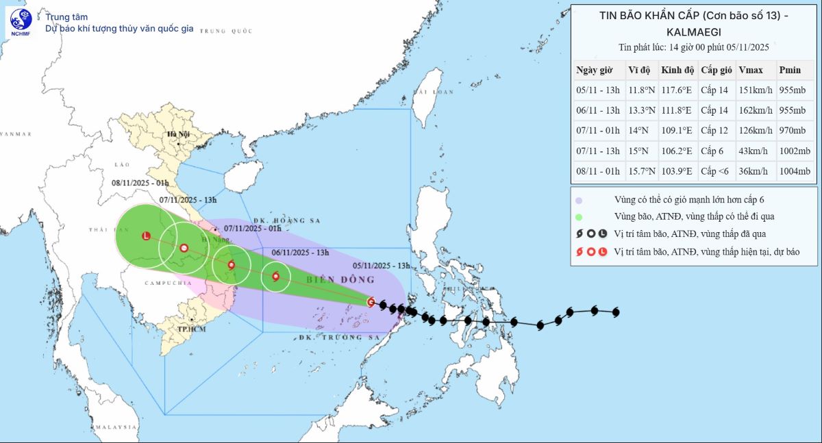
It is forecasted that in the next 3 hours, the storm will move west-northwest, at a speed of about 25 km/h.
Regarding rain forecasts, from November 6-7, the area from Da Nang City to Dak Lak will have very heavy rain with common rainfall of 200-400 mm/ods, locally over 600 mm/ods; the area from southern Quang Tri to Hue City, Khanh Hoa and Lam Dong will have heavy rain with common rainfall of 150-300 mm/ods, locally very heavy rain over 450 mm/ods. From November 8, heavy rain in the above areas tends to decrease.
From November 7-8, the northern area from Quang Tri to Thanh Hoa will have moderate rain, heavy rain with common rainfall of 50-150 mm/ods, locally very heavy rain over 200 mm/ods.


