The latest storm information from the Philippine Atmospheric, Geophysical and Astronomical Services Administration (PAGASA) said that at 9:00 a.m. on October 3 (local time, 8:00 a.m. Hanoi time), Typhoon Matmo (Philippine name: Paolo) made landfall in Dinapigue town, Isabela province, with gusts of level 15, becoming one of the strongest storms to sweep across the northern Philippines since the beginning of the year.
According to PAGASA, the strongest wind near the center of Typhoon Matmo is 130 km/h, gusting up to 180 km/h, moving in the West Northwest direction at a speed of 25 km/h.
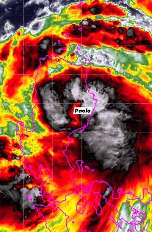
PAGASA said it will raise level 4 wind warning in many areas of Northern Luzon and Aurora province. With complex mountainous terrain, experts warn of the risk of flash floods, landslides and widespread flooding in Isabela, Cagayan, Ilocos and Cordillera.
The area affected by storm Paolo is very large, covering Metro Manila, Batanes, Zambales, Bataan, Central Luzon, Calabarzon, Bicol, Panay, Mindoro, Northern Samar and Eastern Samar. People are advised to limit travel and prepare for strong gusts of wind.
PAGASA forecasts that after sweeping across northern Luzon, Typhoon Matmo will make landfall in the South China Sea this afternoon or evening, becoming the 11th typhoon and may continue to strengthen as it is no longer obstructed by terrain.
Since its formation, Matmo has rapidly strengthened into a typhoon before making landfall, raising concerns about a serious impact on agricultural production and the lives of millions of people in Northern Luzon.
The Vietnam National Center for Hydro-Meteorological Forecasting said that at 7:00 a.m. on October 4, the center of the storm was at 18.0 degrees North latitude, 116.8 degrees East longitude; in the northern sea area of the North East Sea, about 750km southeast of the Lusian Peninsula (China). Intensity level 10-11, gust level 14. Moving west-northwest, about 25 km/h, entering the East Sea and likely strengthening.
At 7:00 a.m. on October 5, the center of the storm was at 19.8 degrees North latitude, 112.1 degrees East longitude; in the northwest sea of the North East Sea, about 200km southeast of the Lusian Peninsula (China). Intensity level 12, gust level 15. Moving west-northwest, 20-25 km/h, it is likely to continue to strengthen.
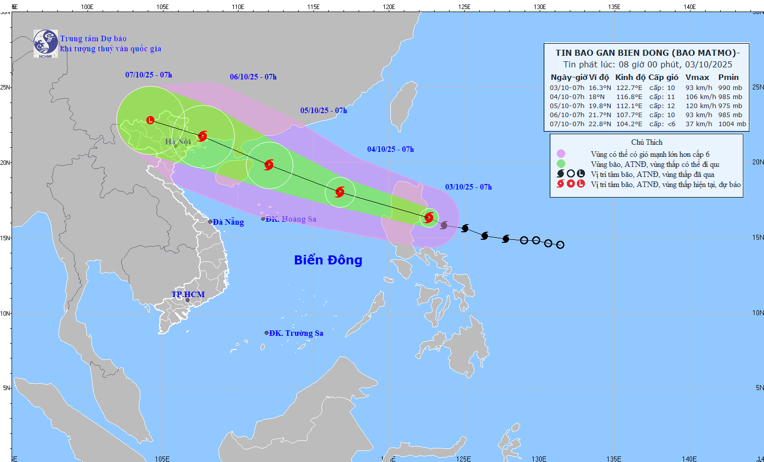
At 7:00 a.m. on October 6, the center of the storm was at 21.7 degrees North latitude, 107.7 degrees East longitude; in the Northeast region of the North. Intensity level 10, gust level 13. Moving west-northwest, 20-25 km/h, entering the North of the Gulf of Tonkin and gradually weakening.
From noon and afternoon on October 3, the sea area east of the North East Sea will have winds gradually increasing to level 6-7; then increasing to level 8-9, near the storm's eye, level 10-11, gusting to level 13, waves 4.0-6.0m high. The sea is rough.
From October 4-5, the northern sea area of the North East Sea is likely to be affected by strong winds of level 11-12, gusting to level 15.
Ship operating in the above-mentioned dangerous areas are likely to be affected by thunderstorms, whirlwinds, strong winds, and large waves.