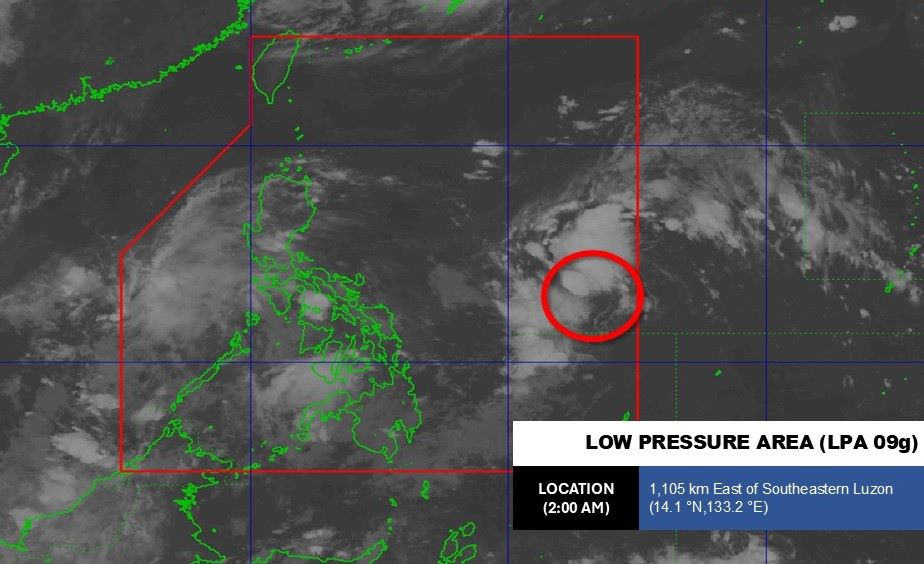
The latest storm information from the Philippine Atmospheric, Geophysical and Astronomical Services Administration (PAGASA) said that at 8:00 a.m. on October 1, the low pressure had strengthened into a tropical depression.
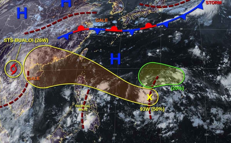
The center of the tropical depression is located at about 14.1 degrees north latitude, 133.0 degrees east longitude, 1,080 degrees east of Southeast Luzon.
"If the tropical depression develops into a tropical cyclone, we will name it storm Paulo," said PAGASA weather forecaster Loriedin de la Cruz.
PAGASA forecasts that in the next 24 hours, the tropical depression is likely to strengthen into a storm. On October 4, the storm is forecast to enter the East Sea and become storm No. 11, the international name is expected to be Matmo, the direction of movement is Northwest.
The name Matmo is an American name, meaning heavy rain. The Northern and North Central provinces of Vietnam may experience a widespread heavy rain from October 6-8.
According to the ECMWF forecast model, the tropical depression is likely to move into the eastern sea of the North East Sea, strengthening into a storm and becoming storm No. 11. The storm is likely to affect Northern Vietnam and enter the midland mountainous provinces of the Northeast.
According to GFS's model, the tropical depression is likely to strengthen into a storm on the night of October 2 and early morning of October 3, on October 3 the storm is likely to sweep across the north of Luzon Island (Philippines) and enter the eastern sea area of the North East Sea, becoming the 11th storm.
Regarding rain forecasts, from October 6-8, the tropical convergence zone may combine with the remnants after the storm, which are likely to cause a widespread heavy rain in the Northern and North Central regions.
Meanwhile, the weather forecast bulletin at 7:30 a.m. on October 1 of the Vietnam National Center for Hydro-Meteorological Forecasting said that in the next 6 hours, there is a risk of flash floods, landslides, and land subsidence on steep slopes and small streams in the provinces: Son La, Phu Tho, Lao Cai, Tuyen Quang, Thai Nguyen, Cao Bang, Lang Son, Bac Ninh, Thanh Hoa, Nghe An.
About Hanoi weather on October 1: The lowest temperature is 24-26 degrees Celsius, the highest temperature is 29-31 degrees Celsius. Cloudy, with occasional showers and thunderstorms in the morning and at night. Southeast wind level 2-3. During thunderstorms, there is a possibility of tornadoes, lightning and strong gusts of wind.
Northwest: Lowest temperature 22-25 degrees Celsius, some places below 22 degrees Celsius. Highest temperature 27-30 degrees Celsius, some places above 30 degrees Celsius. Cloudy, scattered showers and thunderstorms during the day, locally heavy rain; showers and thunderstorms at night in some places. Light wind. During thunderstorms, there is a possibility of tornadoes, lightning and strong gusts of wind.
Northeast: Lowest temperature 23-26 degrees Celsius, mountainous areas below 22 degrees Celsius. Highest temperature 29-32 degrees Celsius. Cloudy, scattered showers and thunderstorms, locally heavy rain. Southeast wind level 2-3. During thunderstorms, there is a possibility of tornadoes, lightning and strong gusts of wind.