According to the latest storm news, on the evening of July 2, the Japan Meteorological Agency (JMA) officially named Mun as a low pressure circulation that is rapidly intensifying and is likely to reach strong typhoon level within the next 48 hours.
According to the latest satellite data, Mun is shaping a mid-level eye structure - a rare sign in a young storm. In particular, this development occurs right in the dry air zone - which is a frequent factor that inhibits the strength of tropical systems.

Images of microwave wave show that the center of Mun's circulation is surrounded by a strong convective cloud belt, although there is still a dry air mass seeping in. However, this system has a strong outflow in all directions (radial outflow) - a mechanism that helps mix and push the dry air mass out, paving the way for the storm to continue to strengthen.
Based on storm forecasts from the KNES and PGTW meteorological centers, storm Mun is currently estimated to reach level T3.0, equivalent to winds of about 83 km/h, gusts of 87 km/h.
Mun is forecast to strengthen into a strong typhoon with winds of nearly 120 km/h on July 5, before encountering colder waters that gradually weaken it.
The Philippine Atmospheric, Geophysical and Astronomical Services Administration (PAGASA) also said on July 3 that it is closely monitoring the path of Typhoon Mun.
At 8:00 a.m. on July 3, the center of the storm was at about 26.9 degrees north latitude, 145.3 degrees east longitude, 2,480 km east-northeast of Luzon. Maximum winds near the center of the storm reached 65 km/h, gusting to 80 km/h, moving at a speed of 15 km/h in the west-northwest direction.
Although Mun is unlikely to make landfall in the Philippines, PAGASA is still closely monitoring it.
On the same day, July 3, a low pressure within the Philippine Forecast Area (PAR) is at medium risk of developing into a tropical depression in the next 24 hours.
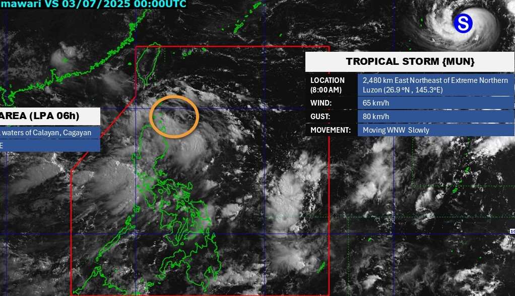
At 8:00 a.m. on July 3, the center of the low pressure was at about 19.5 degrees north latitude, 122.4 degrees east longitude, in the waters of Calayan and Cagayan.
Due to the influence of the low pressure and southwest monsoon, heavy rain and thunderstorms appeared in Ilocos, Cordillera, Cagayan Valley and Aurora.
Prolonged showers in Metro Manila, Pangasinan, Zambales, Bataan, Cavite, Batangas and Occidental Mindoro.
Many localities have announced temporary school closures to ensure the safety of students due to bad weather.
In Vietnam, the National Center for Hydro-Meteorological Forecasting said that on the night of July 2 and the morning of July 3, the Northern region, Thanh Hoa, Nghe An will have showers and thunderstorms, with some places having heavy to very heavy rain.
Rainfall from 7pm on July 2 to 8am on July 3 was over 70mm in some places such as Muong Xen (Nghe An): 125.2mm; Sam Son (Thanh Hoa): 98mm; Quang Lam (Quang Ninh): 81.8mm; Muong Lan 1 (Son La): 76.8mm
On the day and night of July 3, the Northeast and from Thanh Hoa to Ha Tinh will have scattered showers and thunderstorms, locally heavy rain of 10-30mm, some places over 80mm.
In the afternoon and night of July 3, the Northwest, from Quang Tri to Lam Dong, will have rain of 10-30mm, locally over 70mm.
The South (afternoon and evening) has some places with heavy rain over 50mm.


