Typhoon Senyar - a meteorological phenomenon considered "unprecedented" in the Malacca Strait - not only set a series of rare records but also left a low pressure area that is likely to directly impact the East Sea in the next few days.
Under the influence of storm No. 15, this low pressure area may be sucked back into the East Sea and strengthen again into a tropical depression around November 29.
If a new cyclone forms, this will be the 21st tropical cyclone in the East Sea in 2025, surpassing the 20-st storm record of 2017, thereby setting a historical record for the number of active cyclones in 1 year.
Senyar: The "unique" storm in meteorological history
Typhoon Senyar dissipated after making landfall on the West Coast of Malaysia in the early morning of November 28, but was immediately recognized as one of the most special atmospheric phenomena in the Indian Ocean - Northwest Pacific.
According to the Malaysian Meteorological Agency ( MetMalaysia), the storm made landfall at around 1am on November 28 between Banting and Port Dickson, then weakened as it moved into Pahang, but still caused rain in many states due to the remaining low circulation.
The reason Senyar shocked the meteorological world lies in a series of newly established records:
The first tropical storm in more than 180 years to form in the Strait of Malacca, an area considered to be without a storm. Since 1842, no strong tropical cyclones have been recorded at the Senyar site.
The first storm was named at this location by the Indian Meteorological Department (IMD).
The storm has the second lowest latitude since the IMD named it in 2004.
The first storm to hit Sumatra (Indonesia) in November in more than a century of data.
The storm had the strongest winds when it made landfall in Sumatra, surpassing Vamei (2001).
The named storm made landfall in Indonesia for the first time in the North Indian Ocean basin.
The second storm in history to hit the Indonesian territory in the Northern Peninsula.
The first storm to hit Indonesia in November since Typhoon 03S (2001).
MetMalaysia stressed that Malaysia was already out of the tropical storm's path, so the arrival of Senyar was "extremely unusual". This agency continues to issue a warning of heavy rain until November 29 and closely monitor the developments of the remaining circulation.
Low pressure area after Senyar: Risk of rebirth into a cyclone in the East Sea
What is more worrying is the low pressure area that formed after Typhoon Senyar dissipated. This weak tornado is present in western Malaysia and is currently moving slowly.
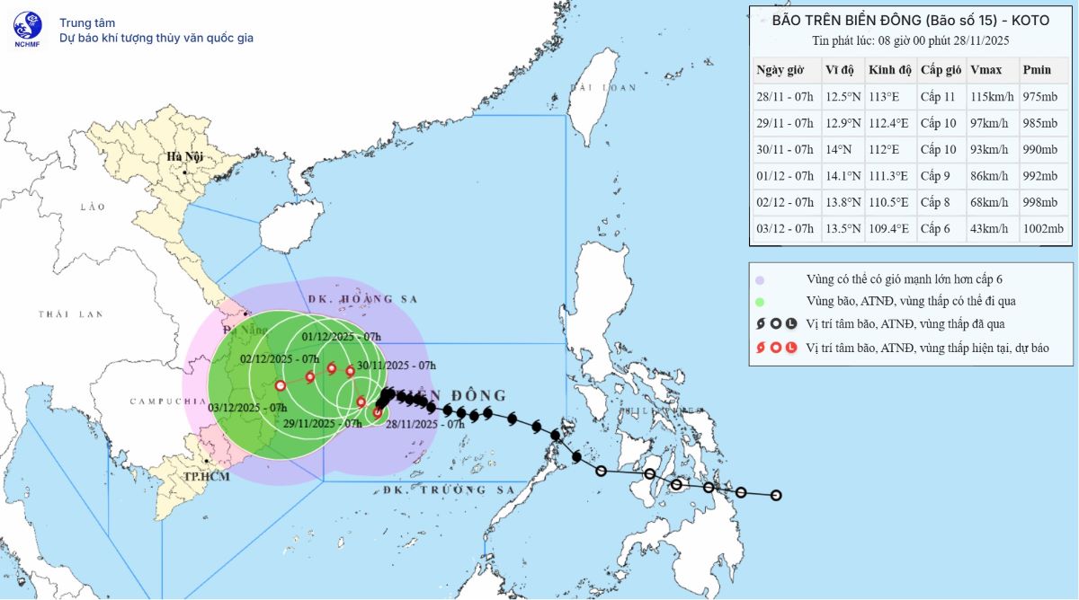
Under the impact of storm No. 15 (at 7:00 a.m. on November 28 at about 12.5 degrees north latitude, 113.0 degrees east longitude, about 190km northwest of Song Tu Tay Island), the low pressure area may be sucked to the east, a phenomenon recorded for the first time between the two climate basins of the Indian Ocean and the Northwest Pacific.
Storm forecast models show that when it moves out into the East Sea, this low pressure area may strengthen into a tropical depression around November 29. If this happens, it will be the 21st low pressure or storm to operate in the East Sea this year - an unprecedented number.


