Southeast Asia on November 27 entered a particularly complex weather period as Typhoon No. 15 Koto continued to strengthen in the East Sea, while Typhoon Senyar formed and rapidly intensified in the Strait of Malacca, directly affecting Indonesia, Malaysia and possibly spreading to the Indian Ocean.
Storm No. 15 Koto strengthens, direction is still uncertain
According to the storm forecast of the Vietnam National Center for Hydro-Meteorological Forecasting, at 4:00 a.m. on November 27, the center of storm No. 15 was at about 13.0 degrees north latitude - 114.5 degrees east longitude, about 190km north of Song Tu Tay Island.
The strongest wind near the storm center is level 12 (118-133 km/h), gusting to level 15. Moving west-northwest, speed about 15km/h.
It is forecasted that by 4:00 a.m. on November 28, the center of the storm will be at 12.5 degrees north latitude - 113.1 degrees east longitude; in the western sea area of the central East Sea, about 190km northwest of Song Tu Tay Island. Strong storm level 12, gusts level 15, moving west-southwest, 5-10 km/h.
It is forecasted that by 4:00 a.m. on November 29, the center of the storm will be at 12.9 degrees north latitude - 112.3 degrees east longitude; in the western sea area of the central East Sea. The storm is level 11, gusting to level 14, moving west-northwest, then northwest, about 5 km/h.
At 4:00 a.m. on November 30, the center of the storm was at about 13.7 degrees north latitude - 112.1 degrees east longitude; in the western sea area of the central East Sea. Intensity level 10, gust level 13, moving north-northwest, 3-5 km/h.
Due to the impact of the storm, the central East Sea area (including the sea area north of Truong Sa special zone) has strong winds of level 7-9; the area near the storm's center has strong winds of level 10-12, gusts of level 15. The waves are 4.0-6.0m high, the area near the storm's center has 7.0 9.0m; the sea is very rough.
Storm Senyar accelerates after overtaking Indonesia
On the west side, Senyar is becoming stronger after sweeping across the northeastern part of Sumatra Island (Indonesia), with winds of 65 km/h and gusts of 80 km/h.
However, according to an update from the Indian Meteorological Agency (IMD), the Senyar has increased to a stronger intensity as it passes through the Malacca Strait, reaching winds of 70-80 km/h, possibly up to 90 km/h before weakening.
The current location of the storm shows a wide range of impact: 80km from Kuta Makmur (Indonesia), 280km from George Town (Malaysia), 580-730km from the Nicobar Islands.
It is forecasted that on the morning of November 27, Senyar will suddenly change direction to the east and gradually weaken in the next 24 hours. This is a common form of change of direction for storms forming in the Malacca Strait.
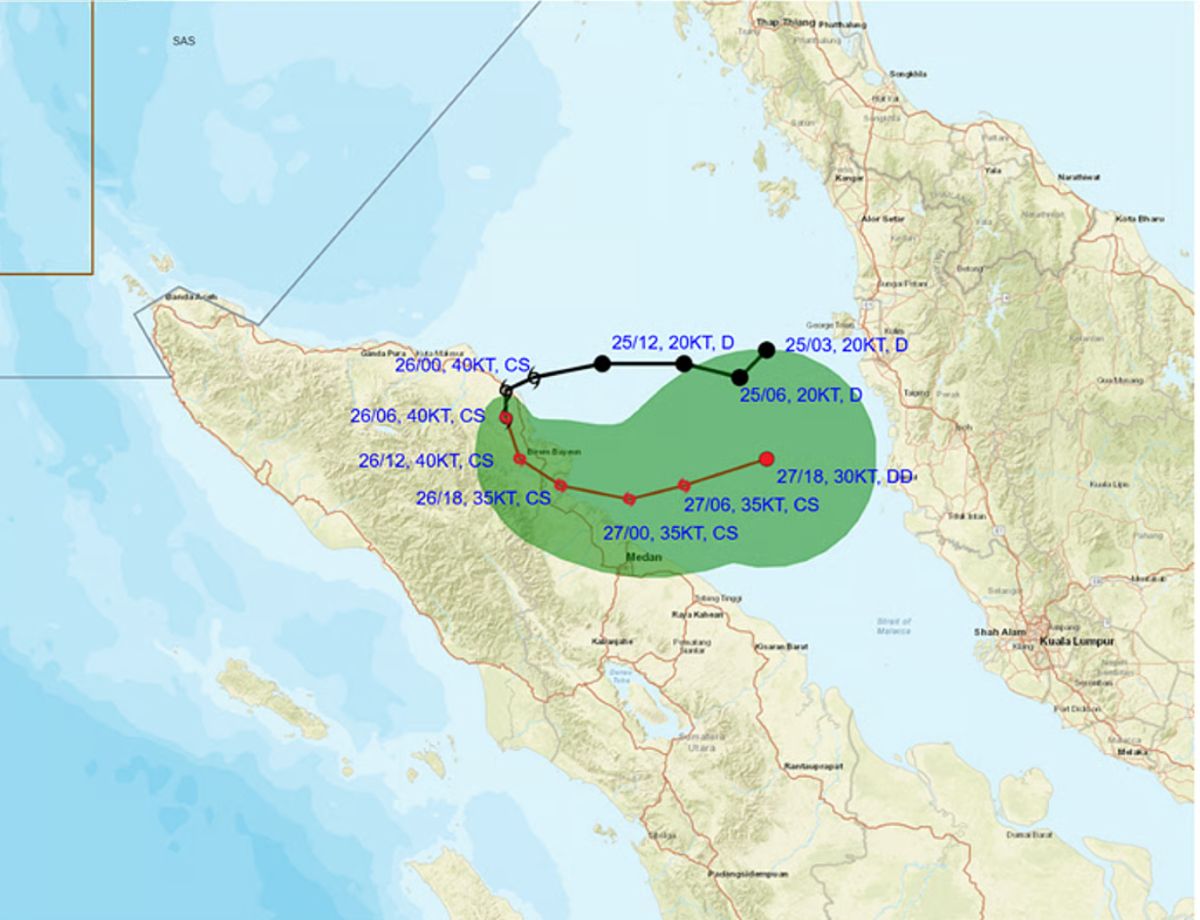
Despite weakness, heavy rains are the most serious risk for Senyar. 100-200mm of rain is forecast over a wide area; 300mm or more in Aceh and northeast Sumatra (Indonesia).
The waves are forecast to be 2.5-4m high, strongly affecting the Malacca Strait and the Indonesian - Malaysian sea area.
While Senyar and 15 Koto are active, IMD recorded another low pressure area forming over the waters of the Bay of Bengal - South Sri Lanka - Indian Ocean equator. This low pressure area could strengthen into a tropical depression in the next 24 hours, then head towards the coasts of Tamil Nadu and Puducherry (India), causing heavy rain in the next 2 days.


