The latest storm/low pressure information from the Philippine Atmospheric, Geophysical and Astronomical Services Administration said that a new low pressure/low pressure is expected to form and enter the Philippine Forecast Area (PAR) in the first week of December and may move closer to Luzon, specifically in the Bicol region.
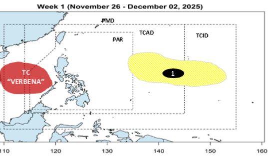
Accordingly, during the week from November 26 to December 2, storm Verbena (storm No. 15) will enter the East Sea and leave the PAR. However, a disturbance/low pressure area (signed No. 1) is forecast to appear far east of the Philippines, at about 15 degrees north latitude, 142 degrees east longitude. Low pressure 1 is unlikely to strengthen into a storm during this period.
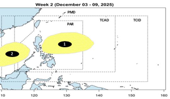
During the week of December 3-9, low pressure 1 is expected to enter the eastern part of PAR, near Bicol, Luzon. The possibility of this low pressure strengthening into a storm is low. If it strengthens into a storm, the storm will be named Wilma after the local name in the Philippines.
There is also a low pressure 2 on PAGASA's storm forecast map this week, most likely a remnant of storm No. 15.
Regarding the development of storm No. 15, according to the Vietnam National Center for Hydro-Meteorological Forecasting, at 1:00 p.m. on November 26, the center of the storm was at about 12.4 degrees north latitude - 116.6 degrees east longitude, about 280km east-northeast of Song Tu Tay Island.
The strongest wind near the storm center is level 9 (75-88 km/h), gusting to level 11. The storm is moving west-northwest at a speed of about 20km/h.
At 1:00 p.m. on November 27, the center of the storm was at about 12.7 degrees north latitude - 111.4 degrees east longitude, in the central East Sea, about 150km north of Song Tu Tay Island.
The storm is likely to strengthen, level 11, gusting to level 14. The storm is moving west-northwest at a speed of about 10km/h.
Disaster risk level: Level 3 in the central East Sea area (including the sea area north of Truong Sa special zone).
At 1:00 p.m. on November 28, the center of the storm was at about 12.4 degrees north latitude - 112.9 degrees east longitude, in the central East Sea, about 200km northwest of Song Tu Tay Island.
Strong storm level 11, gust level 14. The storm is moving west-southwest at a speed of about 5 km/h.
Disaster risk level: Level 3 in the central East Sea area (including the sea area north of Truong Sa special zone).
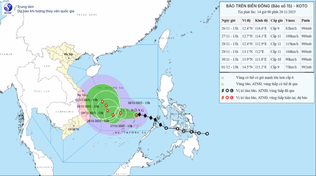
At 1:00 p.m. on November 29, the center of the storm was at about 13.1 degrees north latitude - 112.0 degrees east longitude, in the western sea area of the central East Sea.
Strong storm level 10-11, gust level 14. The storm is moving northwest at a speed of about 5 km/h.
Natural disaster risk level: Level 3 in the western sea area of the central East Sea (including the northwestern sea area of Truong Sa).
Due to the impact of the storm, the central East Sea area (including the sea area north of Truong Sa special zone) has strong winds of level 7-8; the area near the storm's center has strong winds of level 9-11, gusts of level4; waves 4.0-4.0m high, the area near the storm's center has 7.0-4.0m; the sea is very rough.
Ship operating in the above-mentioned dangerous areas are likely to be affected by thunderstorms, whirlwinds, strong winds, and large waves.


