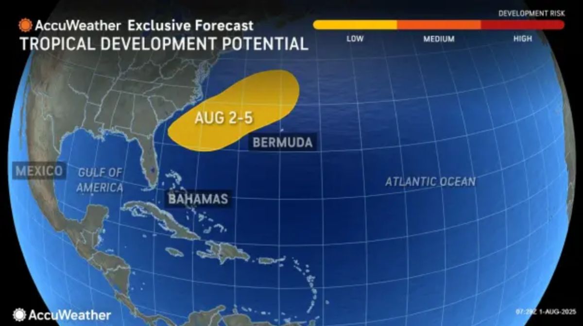
A low pressure area is expected to form on August 3 off the coast of Carolina, US, with a 20% chance of becoming storm Dexter within the next week, according to the latest storm information from the US National Hurricane Center (NHC).
The storm forecast bulletin issued at 1:00 a.m. on August 3, Vietnam time said that the low pressure area will appear off the Southeast coast of the United States and may continue to develop on August 4 as it moves slowly to the east-northeast. However, after this point, environmental conditions will become less favorable for development, the NHC warned.
The likelihood of typhoon formation in the next 48 hours and 7 days is now at 30%, reflecting a low threat level, according to NHC meteorologist Aaron Swiggett.
Although the warning level is not yet high, the appearance of this system marks the more vibrant forecast period of the 2025 Atlantic hurricane season.
Long-term forecast models are starting to show signs of increased activity, said Michael Lowry, a senior analyst at WPLG-TV. Deep tropical waves from Africa are more active this week. The models from July 24 have moved from a quiet forecast to a busier picture for early August.
The Atlantic hurricane season runs from June 1 to November 30 each year, with a peak period from August to October.
The NHC is also monitoring three other tropical waves in the Caribbean, but none of them are expected to threaten land. One is moving west near northeastern Venezuela, another in the central Caribbean, and the final in the northwest Caribbean near Honduras.
In the event that a new low pressure area off the coast of Carolina strengthens into a tropical storm, it will be named Dexter - the next name on the list for the 2025 Atlantic hurricane season.
The formation of this system is a reminder that this year's hurricane season is entering its peak.
The surviving material for hurricane formation is warm ocean waters, and the water surface in the key Atlantic is currently heating up significantly.
The so-called Main Development Region (MDR) - the area between Africa and the Caribbean, where most of the strongest storms have originated - has warmed above the seasonal average in recent weeks, according to WPLG-TV forecaster Michael Lowry.
Not only the MDR, the Gulf of Mexico and the Caribbean are also experiencing unusually high water surface temperatures. In particular, a prolonged high pressure near Florida caused the water near the state's shore to heat up dramatically, as recorded at 32 degrees Celsius in a buoy near Virginia Key, near Miami on August 1.
According to expert Phil Klotzbach from Colorado State University, the sea water needs to reach at least 26.5 degrees Celsius to form a storm. Currently, sea surface temperatures from Africa to the Caribbean to the Gulf of Mexico have all exceeded this threshold, meaning all conditions for the storm are converging.
As the ocean floor heats up comprehensively, not just one but many storms could emerge strongly in the coming weeks - paving the way for the peak of risky typhoons.
Experts are urging US coastal residents and authorities to continue to closely monitor weather forecasts for the coming days.