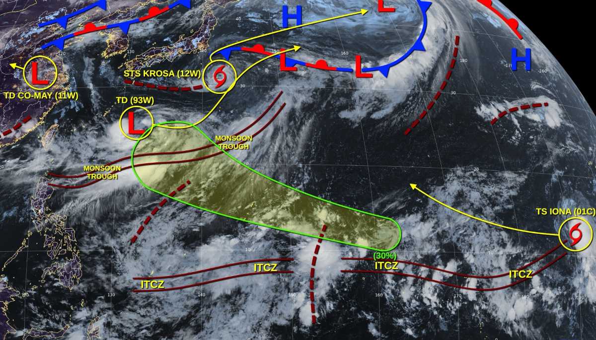
The latest storm information from the Philippine Atmospheric, Geophysical and Astronomical Services Administration (PAGASA) said that low pressure 07j at the Philippine Forecast Area (PAR) is being closely monitored with a high possibility of developing into a tropical depression and possibly entering the PAR, becoming the first storm in August in the country.
"It is likely to enter PAR for a short time and then exit northeast, moving out of the Philippine forecast area," PAGASA weather forecaster Loriedin De la Cruz- curtia explained.
If it strengthens into a storm and enters the PAR, it will be named Fabian, becoming the first storm of August and the sixth storm of 2025 in the Philippines.
Currently, the low pressure does not directly affect any part of the Philippines, except for the possibility of strengthening the southwest monsoon.
According to PAGASA, the Philippines could see up to 16 typhoons from August to December this year, with the strongest activity expected in the coming months.
Ana Liza Solis, a member of PAGASA's Climate Monitoring and Forecasting Department, said that 9 to 16 storms will enter the PAR before the end of 2025.
Of these, there were 2-3 storms in August, 2-4 in September to November and 1-2 in December. There will be no or only one storm in January 2026.
Based on historical records, we actually had more typhoons in July, August and September. Those are also the months of the year that could be hit by more typhoons, Solis said.
PAGASA also noted that the likelihood of La Nina is higher than average, although the Pacific Ocean is currently in a neutral state under the El Nino - Southern Oscillation (ENSO) cycle.
ENSO is a natural climate model that involves periodic fluctuations in sea surface temperatures and atmospheric conditions in the Pacific Ocean, which can affect storm activity in the Philippines.
"Based on 24 typhoon forecast models released by international meteorological centers, most of the models show that the Pacific Ocean will maintain a neutral ENSO state throughout the forecast period from 2025 to 2026," Solis said.
However, she noted that some forecast models suggest a possible La Nina phenomenon could form between August and October 2025 and could last until December 2025 or even February 2026.
Ms. Solis said that the probability of La Nina occurring is currently higher than average. However, she also emphasized that not all models agree. That time is still far away and the situation is still very unpredictable.
The current probability has not yet exceeded the 55% threshold - the level needed for PAGASA to issue an official warning about the La Nina phenomenon. If La Nina appears, it will likely be only at a weak level or short-lived.
The La Nina phenomenon is often associated with heavier than average rainfall and the risk of more tropical cyclones in the Philippines.
PAGASA called on local people and authorities to continue to closely monitor the weather and remain vigilant as the storm season is intensifying.