Hurricane Erin is entering a journey of more than 2 weeks across the North Atlantic, forecast to soon strengthen into the strongest storm since the beginning of the storm season according to the classic trajectory and last for many days.
Erin was named on August 11, after sweeping across the Cabo Verde Islands on August 10 as a strong disturbance. At 11:00 ( EDT) on August 12, the center of the storm was located about 480km west-northwest of Cabo Verde, moving west at a speed of 32 km/h, with sustained winds of 72 km/h.
According to statistics from 1990-2020, the fifth storm of the Atlantic hurricane season typically forms on August 22, and the first typically appears on August 11. Erin is forecast to reach strong typhoon status on August 13.
The waters under Erin will have temperatures around 26 degrees Celsius - the minimum for tropical storm formation. This is a rare starting point: In 174 years of data from the US National Oceanic and Atmospheric Administration (NOAA), only 41 storms have developed or passed through areas 320km from Erin's current location.
The two strongest storms to hit the site in the past few decades - Florence (2018) and Irma 2017 - both caused tens of billions of dollars in damage and killed at least 50 people.
Storm models agree that Erin is likely to strengthen into a major hurricane (level 3 or higher on the 5-point Saffir Simpson hurricane scale) this weekend, as it moves across the warming waters from 28 degrees Celsius on August 14 to 29 degrees Celsius on August 16, with ocean heat reserves 1 degree Celsius above average.
While wind shear may increase slightly in the middle of the previous week when it drops over the weekend, Erin's small size allows it to increase or decrease its strength rapidly. The National Hurricane Center forecasts Erin to reach Category 3 status on August 16.
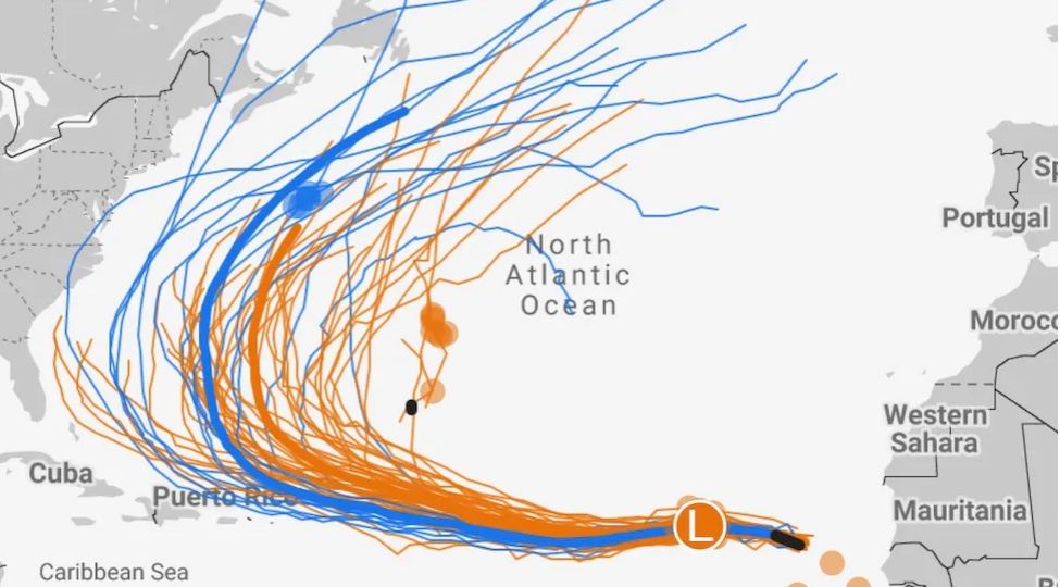
Most models, including Google AI's experimental forecast, predict that Erin will change direction to the north and northeast, passing near Bermuda rather than making landfall on the east coast of the United States, due to the impact of a high pressure trough moving across the northeastern United States and eastern Canada. However, this change will only start after at least 1 week, so the development still needs to be closely monitored.
If this scenario occurs, Erin could still create large waves, strong shore waves, coastal erosion and dangerous offshore currents along the Atlantic coast of North America and the northern Antilles.
For at least the next week, Erin is forecast to be the only worrying storm in the Atlantic, with other disturbances having a maximum of a 10% chance of developing, and a low pressure area off the Gulf of Mexico has almost no chance of forming a hurricane.