The storm forecast for the morning of June 9 of the Philippine Atmospheric, Geophysical and Astronomical Services Administration (PAGASA) said that the low pressure area near the East Sea is moving slowly but combined with the southwest monsoon, causing heavy rain in many areas, especially the western coastal areas and mountainous provinces.
At 2:00 a.m. on June 8, the center of the low pressure was at about 17.1 degrees north latitude, 119.7 degrees east longitude, 75km west-northwest of Bacnotan, La Union. Although not yet strengthened into a storm, the low pressure is interacting with the southwest monsoon, causing rainfall to skyrocket in many provinces in the Central and Northern Philippines.
In Pangasinan alone, rainfall forecast for June 9 and 10 will range from 50-100 mm, enough to cause localized flooding in low-lying areas, while mountainous areas may face the risk of flash floods and landslides.
The southwest monsoon is active, affecting most of the regions from southern Luzon, Visayas to Mindanao. Forecasts show that rainfall will continue to increase in the western provinces, 100-200 mm in Occidental Mindoro and Zambales.
The southwestern sea of Luzon and Visayas will have moderate to strong southwest winds, with waves from 1.2-2.8m high. Small vessels are advised not to depart for sea without specific instructions from authorities.
PAGASA emphasized that the public as well as local disaster risk management offices need to prepare response plans in case of extreme weather conditions such as heavy rain, localized floods or landslides.
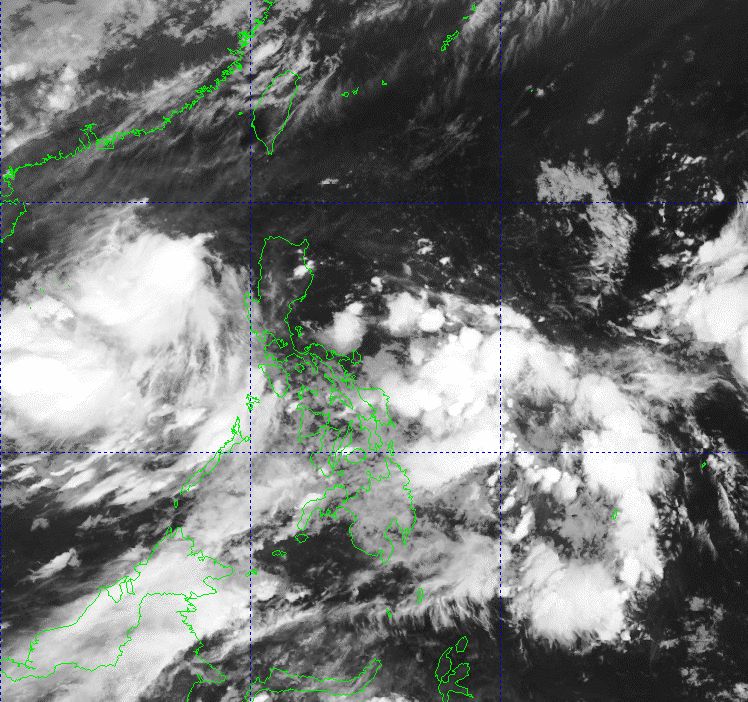
The Vietnam National Center for Hydro-Meteorological Forecasting (NCHMF) also said that at 1:00 a.m. on June 9, the low pressure trough with an axis passed through the northern East Sea connecting with the low pressure area at about 16.5-17.5 degrees north latitude; 117.5-118.5 degrees east longitude.
The southern sea area of the North East Sea (including the Hoang Sa archipelago), Central and South East Sea (including the Truong Sa archipelago), the sea area from Binh Thuan to Ca Mau, Ca Mau to Kien Giang and the Gulf of Thailand are experiencing showers and thunderstorms.
At Huyen Tran station, gusts of wind of level 8-9 were recorded.
On the day and night of June 9, the following sea areas will continue to have showers and thunderstorms: South of the North East Sea (including the Hoang Sa archipelago); Central and South East Sea (including the Truong Sa archipelago); sea area from Binh Dinh to Ca Mau; sea area from Ca Mau to Kien Giang; Gulf of Thailand
On the night of June 9, the Gulf of Tonkin will have scattered showers and thunderstorms. During thunderstorms, there is a possibility of tornadoes, strong gusts of wind of level 6-7, waves over 2m high
The sea area from Binh Thuan to Ca Mau, the south of the area between the East Sea and the South East Sea (including the Truong Sa archipelago) has strong southwest winds of level 5, sometimes level 6, gusting to level 7-8; rough seas. Waves are 1.5-3m high.