The latest storm and low pressure information from the Philippine Atmospheric, Geophysical and Astronomical Services Administration (PAGASA) said that the low pressure area near the East Sea has entered the Philippine Forecast Area (PAR) since June 6 and may strengthen into the No. 1 storm of 2025 within the next 24 hours.
"The low pressure area that we have been monitoring in the Pacific has entered the Philippine forecast area at 2:00 a.m. on June 6," said PAGASA weather expert Benison Estareja.
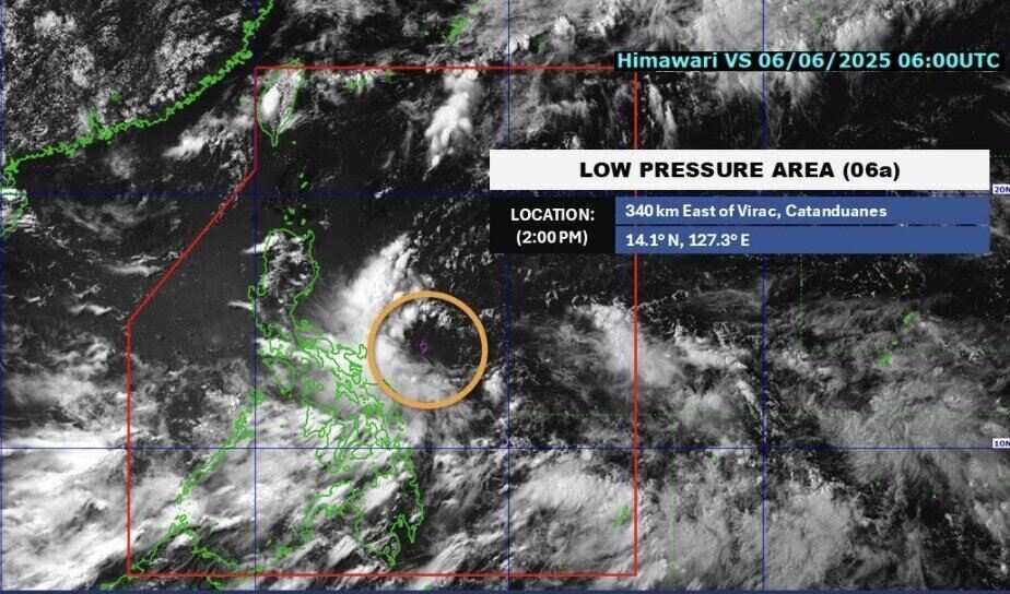
At 2:00 p.m. on June 6, the low pressure near the East Sea was about 340 km from East Virac, Catanduanes. At 11:37 a.m. the same day, the low pressure was about 424 km east of Borongan, Eastern Samar, Philippines. Earlier, at 3 a.m. the same day, the depression was 945 km east of Visayas.
Estareja noted that the possibility of the low pressure near the East Sea strengthening into a tropical depression is moderate. "Based on our latest analysis, if the possibility of the low pressure strengthening on June 5 is low, the possibility of strengthening on June 6 is at an average level," he said.
If the low pressure near the East Sea strengthens into a tropical depression on June 7 or 8, the system will begin to be named Auring - the first storm name in the list of storm names for the 2025 typhoon season in the Philippines.
PAGASA typhoon forecaster Chris Perez said on June 6: "Although the low pressure has a moderate chance of strengthening into a typhoon in the next 3 to 5 days, the impact of this system is expected to occur in many areas of the Philippines, especially the provinces in Southern Luzon and Eastern Visayas".
PAGASA said that the low pressure near the East Sea is expected to approach the Philippines more this weekend. "The scenario for this system is still subject to change, but it is certain that this system will cause rain in many areas of Bicol, Visayas and Caraga," said weather expert Estareja.
He added that as it approaches land, the low pressure will intensify the southwest monsoon, causing rain not only in Luzon but also in the western parts of Visayas and Mindanao.
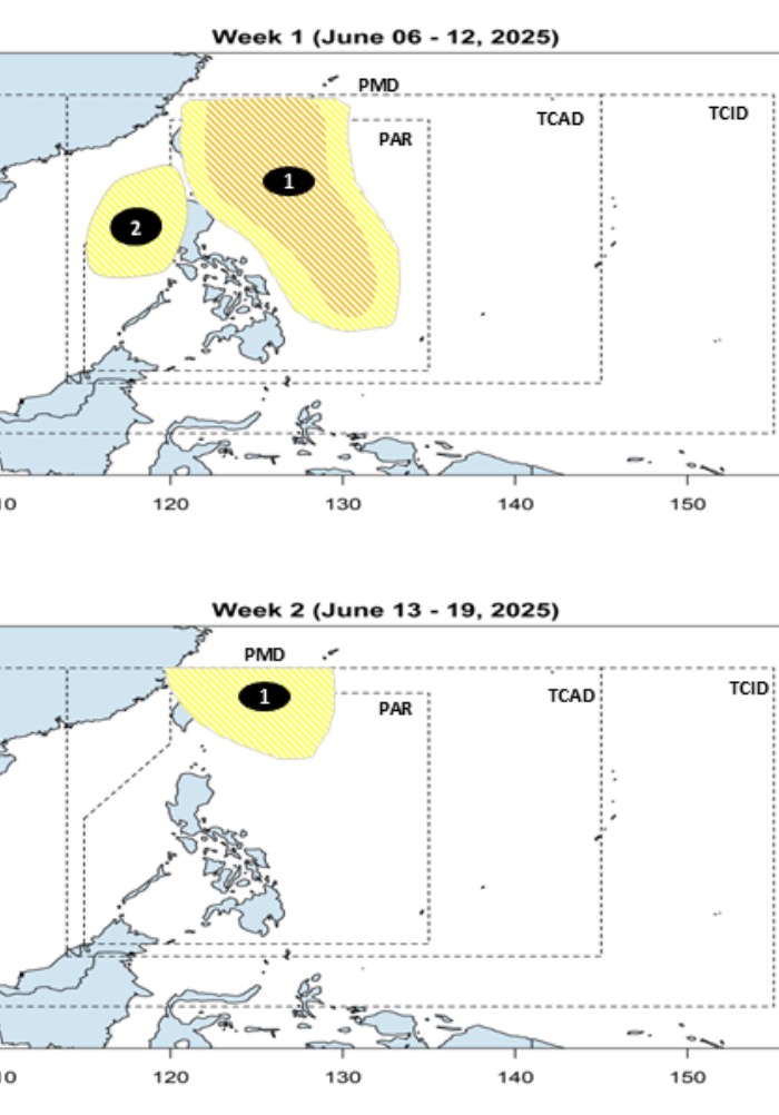
PAGASA's storm forecast on June 6 said that from June 6 to June 19, there will be a storm that is likely to form near the East Sea.
The bulletin said that during the week from June 6 to June 12, the low pressure is expected to appear in the Philippine Sea with the possibility of strengthening into a low to moderate storm.
This low pressure near the East Sea will continue to affect the area until next week from June 13 to 19. The depression will move north of the PAR, with the possibility of strengthening into a storm.
In addition to the low pressure near the East Sea, a low pressure in the East Sea is expected to form during the week of June 6 to June 12, with the possibility of appearing in the western part of the PAR, Philippine weather forecasters said. This low pressure is likely to strengthen into a storm.


