Although there are currently no officially active storms, low pressure areas and disturbances are starting to form densely - a sign of an upcoming unstable weather period.
The latest storm information on June 7 from the US Joint Typhoon Warning Center (JTWC) said that off the east coast of Samar Island (Philippines), a small low pressure area marked 92W is existing with a relatively clear circulation. The forecast shows that 92W will not have the chance to develop into a tropical cyclone, but will instead be sucked into a stronger low pressure area to the east, designated 93W.
Low pressure area 93W, located near Yap Island, is currently the focus of meteorological monitoring. This system is considered the main core of the monsoon and is showing signs of strong development. The circulation became increasingly clear and the wind reached level 6-7. Although thunderstorms are still scattered, atmospheric conditions in the next few days are considered quite favorable for 93W to develop and merge with 92W to become a tropical depression or storm.
The Northwest Pacific typhoon is likely to be the number 1 typhoon of 2025 between June 9-12.
The possibility of storms going into the East Sea area or not is still open. However, according to many forecasts of international models, when moving to the Northwest, 93W will absorb 92W, becoming the main weather system, which can affect Taiwan (China), Yaeyama and Okinawa Islands (Japan). At the same time, the whole process will cause heavy rain in the Philippines to increase significantly in the next days.
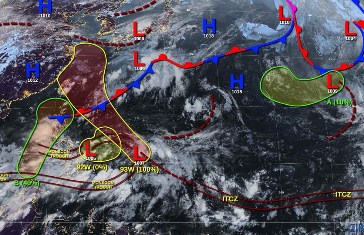
Further northeast, an untropical depression tracked as A is drifting near Wake Island. Although there is clear circulation and strong winds of about 50-55 km/h, the possibility of storm formation is very low.
Another notable area is a low pressure area off the west coast of Palawan Island (Philippines). The low pressure with this sign B is likely to develop into a short-term tropical depression around the beginning of next week. However, with the dominance of Depression 93W and interaction with Luzon Island terrain, its development opportunities will rapidly decline from midweek.
In general, although there are no storms yet, the Northwest Pacific is entering the early stages of the storm season with clear signs of warming up.
The weather forecast bulletin of the Vietnam National Center for Hydro-Meteorological Forecasting said that on June 8, the Central and South East Sea (including the Truong Sa archipelago), the sea from Binh Thuan to Ca Mau, Ca Mau to Kien Giang and the Gulf of Thailand will have scattered showers and thunderstorms. Strong gusts of wind of level 6-7 and waves over 2m high.
The sea area from Binh Thuan to Ca Mau and the South East Sea area will have strong southwest winds of level 5, sometimes level 6, gusting to level 7-8, rough seas. Waves are 1.5-2.5m high.
After a series of hot days, local heavy rain, tornadoes, lightning, hail and strong gusts of wind are forecast in the Northern region, Hoa Binh, Thanh Hoa and the Central Highlands. Flash floods, landslides, subsidence due to floods or water flow may occur in Thanh Hoa, Dak Nong, Dak Lak provinces.


