Forecast of the possibility of low pressure in the Philippines strengthening into a storm in 24 hours

Khánh Minh |

According to the latest storm/low pressure information, a low pressure has just formed in the Philippines on the morning of June 29.

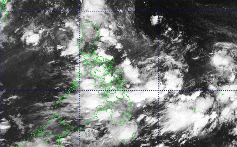
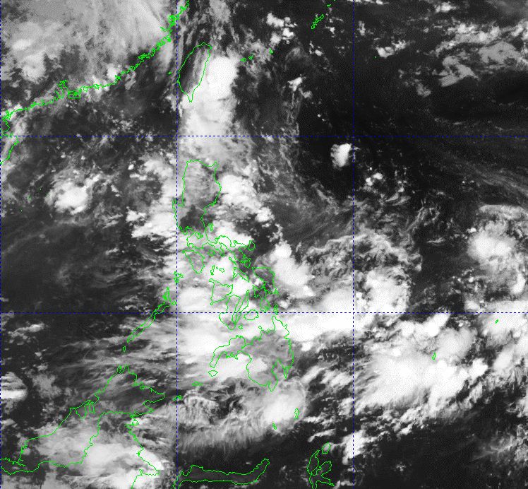
The Philippine Atmospheric, Geophysical and Astronomical Services Administration (PAGASA) said it is monitoring a low pressure area forming outside the Philippine Forecast Area (PAR).

At 2:00 a.m. on June 29, the center of the low pressure was at about 14.9 degrees north latitude, 135.6 degrees east longitude, about 1,240 km east of southeast Luzon. According to PAGASA's initial assessment, the possibility of this low pressure area strengthening into a tropical depression or storm in the next 24 hours is low.

If it maintains its current direction, the low pressure area is likely to move northwest to the northeastern part of Luzon from July 1 to July 4, bringing widespread thunderstorms in Luzon and the Visayas.

At the same time, thunderstorms were also reported in Metro Manila, tarlac, Pampanga, Bataan, Batangas, Cavite, Laguna, Quezon and Rizal due to strong convective clouds.

PAGASA said that due to the influence of the southwest monsoon, thick clouds and heavy rain will cover many areas of the country's west on June 29.

Do anh huong cua gio mua tay nam, mua dong bao phu nhieu khu vuc phia tay Philippines ngay 29.6. Anh: PAGASA
Due to the influence of the southwest monsoon, thunderstorms will cover many areas of the western Philippines on June 29. Photo: PAGASA

Although the low pressure area is far away and has not shown any clear signs of strengthening, meteorological experts continue to closely monitor as weather fluctuations in the Philippine Sea may become complicated in the coming days, especially when the rainy season is at its peak.

People in high-risk areas are advised to regularly monitor weather forecasts from authorities to promptly respond in case this weather pattern changes faster than expected.

Meanwhile, according to the Vietnam National Center for Hydro-Meteorological Forecasting, on June 29, there will be showers and thunderstorms in the following areas: the North of the Gulf of Tonkin; the North East Sea (including the Hoang Sa archipelago); the sea area east of the central East Sea; the Gulf of Thailand. On Phu Quy island, there are southwest winds of level 5, sometimes level 6, gusting to level 7.

It is forecasted that on the night of June 29 and June 30, the following seas will continue to have showers and thunderstorms: Gulf of Tonkin; North and Central East Sea (including the sea area of Hoang Sa archipelago); Gulf of Thailand. During thunderstorms, there is a possibility of tornadoes, strong gusts of wind of level 6-7, waves over 2m high.

Sea area from Ninh Thuan to Ca Mau: Strong southwest wind level 5, sometimes level 6, gust level 7, waves 2-3m high, rough seas.

Warning: All ships operating in the above areas are at risk of being affected by tornadoes, strong gusts of wind and large waves.

Khánh Minh
TIN LIÊN QUAN

4 low pressure areas near the East Sea are expected to strengthen, heavy rain is forecast to fall from today

|

A low pressure area forming near the East Sea is forecast to cause heavy rain with an intensity of over 100mm in 3 hours, accompanied by tornadoes, hail, and strong gusts of wind.

Low pressure near the East Sea may form from this week, this year's storm is likely to make landfall

|

The low pressure may form near the East Sea from this week with a very wide area of influence. Forecasters also said that this year's storm will easily make landfall.

Three low pressure areas waiting to strengthen into storms in the storm center near the East Sea, forecast of heavy rain and thunderstorms

|

storms near the East Sea are heating up every day with 3 low pressure areas operating at the same time.

The Ministry of Public Security guides vehicle registration after July 1

|

Implementing the policy of arranging and reorganizing administrative units at all levels, the Ministry of Public Security has just issued instructions to local police on vehicle registration.

Russia launches nearly 540 UAVs and missiles, Ukraine suffers unprecedented attack

|

Russia launched a series of fierce airstrikes, simultaneously launching a total of nearly 540 missiles and unmanned aerial vehicles (UAVs) into Ukrainian territory.

Stock market waiting for liquidity boom

|

The stock market may have a few adjustment sessions in the context of still waiting for positive supporting information.

A series of important policies take effect from July 1, 2025

|

Chairmen of commune-level People's Committees with the authority to issue Red books; norms for cars serving general work at the commune level... are some important policies effective from July 1, 2025.

4 low pressure areas near the East Sea are expected to strengthen, heavy rain is forecast to fall from today

Ngọc Vân |

A low pressure area forming near the East Sea is forecast to cause heavy rain with an intensity of over 100mm in 3 hours, accompanied by tornadoes, hail, and strong gusts of wind.

Low pressure near the East Sea may form from this week, this year's storm is likely to make landfall

Thanh Hà |

The low pressure may form near the East Sea from this week with a very wide area of influence. Forecasters also said that this year's storm will easily make landfall.

Three low pressure areas waiting to strengthen into storms in the storm center near the East Sea, forecast of heavy rain and thunderstorms

Khánh Minh |

storms near the East Sea are heating up every day with 3 low pressure areas operating at the same time.