Dự báo bão của Cục Quản lý Thiên văn, Địa vật lý và Khí quyển Philippines (PAGASA) cho biết, Julian - vẫn là áp thấp nhiệt đới trên Biển Philippines vào sáng 28.9 - có thể đổ bộ vào Batanes ngày 30.9 dưới dạng bão và thậm chí không loại trừ khả năng mạnh lên thành siêu bão - tờ Rappler đưa tin.
Theo tin bão mới nhất của PAGASA, vào hồi 5h ngày 28.9, vị trí tâm áp thấp nhiệt đới Julian ở vào khoảng 18,6 độ vĩ bắc, 125,4 độ kinh đông, cách Aparri, Cagayan 400km về phía đông.
Sức gió tối đa gần tâm áp thấp nhiệt đới 55 km/h, giật 70 km/h, áp suất trung tâm là 1002 hPa.
Áp thấp đang di chuyển về phía nam với tốc độ 10 km/h. Phạm vi gió mạnh lan ra ngoài tới 360km từ tâm áp thấp nhiệt đới.
PAGASA cảnh báo, luồng gió hướng về hoàn lưu của áp thấp nhiệt đới cũng có thể mang theo gió giật mạnh đến cấp bão ở một số khu vực, đặc biệt là ở các vùng ven biển và vùng cao tiếp xúc với gió trong ngày 28.9 gồm Aurora, Quezon, Camarines Norte, Camarines Sur và Catanduanes.
Biển động dữ dội với sóng cao 4m trên bờ biển Batanes, Quần đảo Babuyan và bờ biển phía đông của đất liền Cagayan. Tàu bè được khuyến cáo không nên ra khơi trong những điều kiện này.
Biển động vừa phải với sóng cao 3m trên phần còn lại của bờ biển Cagayan và bờ biển Isabela.
Cảnh báo gió lớn cũng có khả năng được đưa ra trên bờ biển Bắc Luzon.
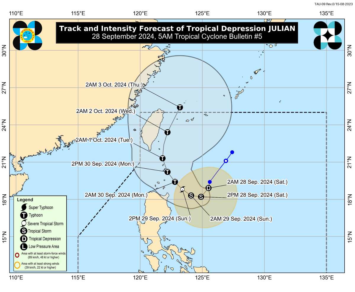
Julian được dự báo sẽ đi theo đường vòng qua vùng biển phía đông Batanes và Cagayan trong 5 ngày tới.
Trong 12 giờ tới, áp thấp nhiệt đới được dự báo sẽ di chuyển về phía tây nam trước khi chuyển hướng về phía tây vào chiều 28.9 trong khi giảm tốc.
Sau đó, nó sẽ di chuyển về phía tây bắc từ ngày mai (29.9) cho đến thứ Ba (ngày 1.10) trước khi chuyển hướng về phía bắc đến đông bắc trong thời gian còn lại của giai đoạn dự báo.
Dựa trên đường đi dự báo mới nhất, Julian có thể đổ bộ vào Batanes vào chiều hoặc tối 30.9 hoặc tối ở cấp độ bão và có thể rời khỏi khu vực dự báo của Philippines (PAR) vào tối thứ Tư (ngày 2.10) đến sáng sớm thứ Năm (ngày 3.10).
Julian sẽ tiếp tục mạnh lên trong suốt giai đoạn dự báo và có thể đạt đến cấp bão nhiệt đới vào hôm nay (28.9). Nó có thể đạt đến cấp bão cuồng phong vào ngày 30.9, đồng thời có khả năng tăng cường nhanh chóng và không loại trừ khả năng đạt đến cấp siêu bão.
Julian là cơn bão nhiệt đới thứ 10 của Philippines trong năm 2024 và cũng là cơn bão nhiệt đới thứ 6 chỉ tính riêng trong tháng 9.
PAGASA cũng tiếp tục theo dõi bão nhiệt đới Jebi, hiện nằm ngoài PAR. Vào hồi 2h ngày 28.9, vị trí tâm bão Jebi ở vào khoảng 19,4 độ vĩ bắc, 144,5 độ kinh đông, cách Cực Bắc Luzon 2.420 km về phía đông.
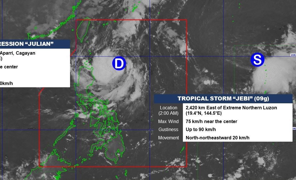
Sức gió mạnh nhất gần tâm bão đạt 75 km/h, giật 90 km/h. Bão di chuyển theo hướng đông đông bắc, mỗi giờ đi được 20km.
PAGASA trước đó cho biết Jebi dự kiến sẽ không đi vào PAR. Bão có khả năng mạnh lên thành bão cuồng phong và đe dọa Đài Loan (Trung Quốc) vào tuần tới.
Jebi là cơn bão nhiệt đới thứ 17 của mùa bão 2024 ở Tây Thái Bình Dương và là cơn bão thứ 7 trong tháng 9 - tháng có số lượng bão cao nhất.


