The latest storm/low pressure information from the Philippine Atmospheric, Geophysical and Astronomical Services Administration (PAGASA) said that at 2:00 a.m. on December 3, the center of low pressure 12a was at about 14.3 degrees north latitude, 135.4 degrees east longitude, 1,210km east of southeast Luzon. The low pressure is likely to strengthen into a tropical depression and enter the Philippine Forecast Area (PAR) today.
PAGASA said that this low pressure/tropical depression is likely to affect the central Philippines.
The potential tropical depression is expected to bring widespread to widespread rain starting on December 4, especially in the Visayas, parts of Southern Luzon and Mindanao. People in these areas are advised to be vigilant against the risk of flooding and landslides.
Meanwhile, the Intertropical Convergence Zone (ITCZ) continues to affect weather conditions in Mindanao, bringing light to moderate rain to the Zamboanga Peninsula, Basilan, Tawi-Tawi, SOCCSKSARGEN, Davao Region and some areas of Caraga.
Northeast Luzon is under the influence of the northeast monsoon, with light rain or thunderstorms expected in the Batanes and Babuyan Islands.
localized thunderstorms may also occur across the rest of the country.
If the tropical depression strengthens into a storm within the PAR, the storm will be named storm Wilma.
According to PAGASA's forecast, the low pressure will pass through the Dinagat - Visayas - Southern Luzon region of the Philippines. If it strengthens into a storm, potential storm Wilma will pass through Mindoro - Northern Palawan of the Philippines before entering the East Sea during the week of December 9 to December 15.
Meanwhile, according to the Vietnam National Center for Hydro-Meteorological Forecasting, around December 7-8, the tropical depression in the Philippines may enter the East Sea. However, whether this tropical depression will strengthen into storm No. 16 or not is still uncertain, and further monitoring is needed.
The center also said that after storm No. 15, there is a high possibility of a storm or tropical depression appearing in the East Sea in December. Thus, after storm No. 15, the storm season has not ended and still needs to be monitored further. According to the law, storms and tropical depressions in December will mainly affect the South Central and Southern regions.
Meanwhile, storm No. 15 has weakened into a tropical depression. At 1:00 a.m. on December 3, the center of the tropical depression was at 13.6 degrees north latitude, 111.4 degrees east longitude, in the northwest sea of the central East Sea. The strongest wind is level 6, gusting to level 8. Moving slowly, south-southwest, 3 km/h.
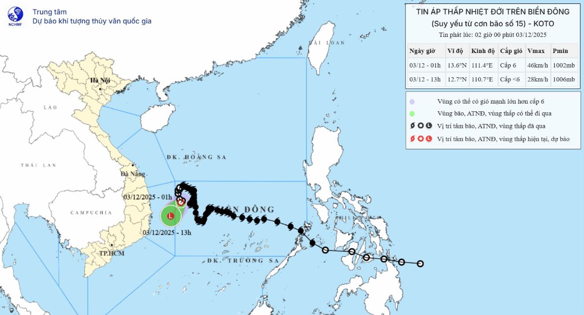
It is forecasted that by 1:00 p.m. on December 3, it will move south-southwest, 5-10 km/h, expected location is 12.7 degrees north latitude, 110.7 degrees east longitude, in the Dak Lak - Khanh Hoa sea area. Weakened into a low pressure area ( below level6).
Dangerous area: 12.0-14.5 degrees north latitude; 110.0-112.0 degrees east longitude.
Natural disaster risk level: level 3 (northwest of the central East Sea, off the coast of Gia Lai - Dak Lak).
Due to the impact of the low pressure, the northwest area between the East Sea and the Gia Lai - Dak Lak sea has winds of level 6, gusts of 8, waves of 2-4 m, rough seas. Ship in the danger zone may encounter thunderstorms, whirlwinds, strong winds, and large waves.


