La Nina forecast to continuously cause new storms near the East Sea, with the risk of widespread heavy rain

Khánh Minh |

The storm is forecast to appear consecutively near the East Sea in early November as La Nina resonate with MJO causing widespread heavy rain.

The latest storm forecast from the Philippine Atmospheric, Geophysical and Astronomical Services Administration said that during the week from October 30 to November 5, there will be 3 low pressure areas around the Philippines.

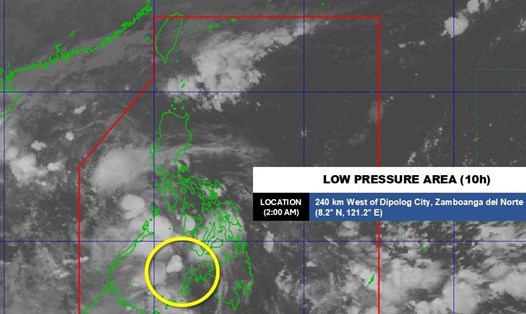
Low pressure 1 will form in the Sulu Sea, near the East Sea, with the possibility of strengthening into a storm.

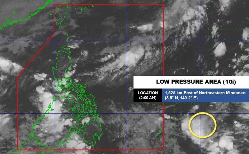
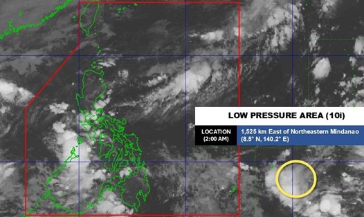
Low pressure 2 has appeared outside the Philippine Forecast Area (PAR), southeast of Mindanao. This low pressure is forecast to have a high chance of strengthening into a storm around November 2 or 3 and will be locally named storm Tino - the 20th storm to make landfall in the Philippines this year.

According to PAGASA, there are two scenarios for this potential storm. One is to move slowly northwest over the Philippine Sea and could make landfall in Northern Luzon by the end of next week.

The second is moving west-northwest and could make landfall in Eastern Visayas around November 4.

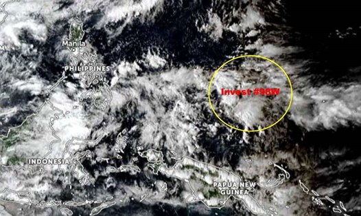
Low pressure 3 is also expected to appear far east of the Philippines before November 5.

Du bao bao/ap thap tuan tu. Anh: PAGASA
Storm/low pressure forecast for the week of October 30 to November 5. Photo: PAGASA

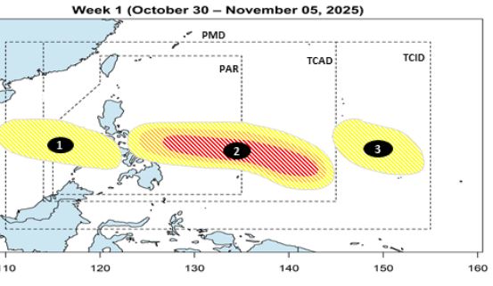
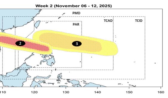
By the week of November 6-12, potential typhoon Tino is forecast to pass through Visayas - Southern Luzon and enter the East Sea. Low pressure 3 is expected to enter PAR, heading north of Luzon, with a moderate chance of strengthening into a storm.

Du bao bao/ap thap tuan tu 6-12.11. Anh: PAGASA
Storm/low pressure forecast for the week of November 6 12. Photo: PAGASA

Meanwhile, according to the US National Oceanic and Atmospheric Administration (NOAA)'s Climate Prediction Center (CPC), the Madden-Julian fluctuations (MJO) will strengthen strongly in the second half of October and are combining with La Nina, creating an unprecedented convection zone since August, covering the East Sea and Southeast Asia.

The CPC also warned of the possibility of a new storm appearing east of the Philippines in early November, along with the risk of heavy rain exceeding the standards in many tropical areas, from the western Pacific to the Caribbean.

GEFS and ECENS forecast models show that MJO may weaken in the second week of November. However, even if weakened, the MJO is still strong enough to impact rainfall and the likelihood of global tropical storm formation in the first half of November.

Du bao bao, mua toan cau tu ngay 5-18.11.2025. Anh: NOAA/CPC
Global storm and rain forecast from 5-18.11.2025. Photo: NOAA/CPC

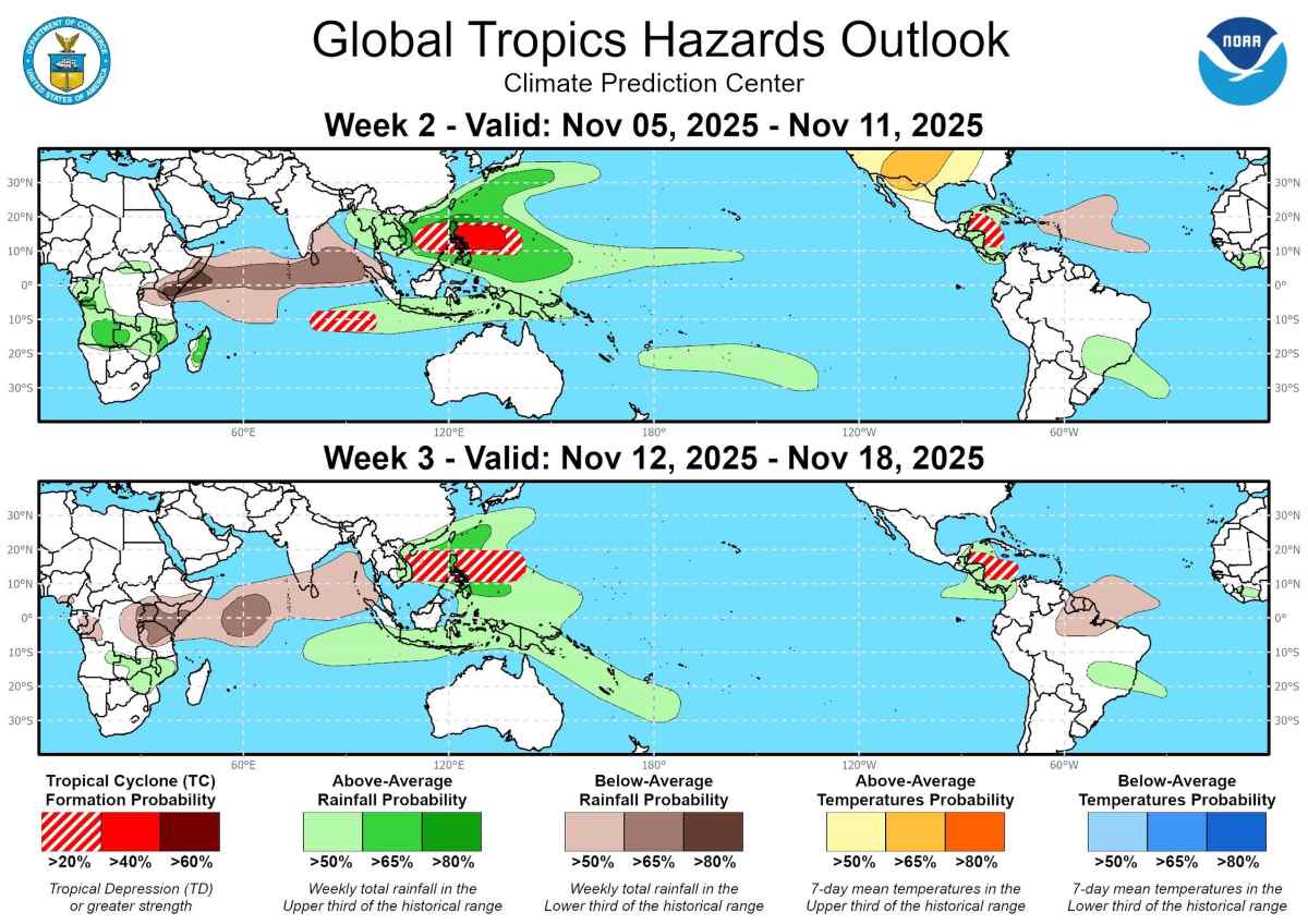
According to the global climate model, the probability of storm formation in the western Pacific will reach over 40% in the period from November 5-19. Scenario with multiple models: A tropical storm will form east of the Philippines early or just before the second week of November, then move across Luzon Island or the central Philippines.

At the same time, the southeastern Indian Ocean also has a 20-40% chance of developing a typhoon.

By the week of November 12-18, the probability of storms in the East Sea and the western Pacific is forecast to be 20-40%.

Based on the GEFS, CFS and ECMWF model combinations, and the influence of MJO and La Nina, areas with the potential for above-average heavy rain in the first two weeks of November include: Southeast Asia, especially Indonesia, Malaysia, the Philippines and Vietnam; the western and southern Pacific; Central America and the Caribbean (especially Jamaica and Cuba). In contrast, the African hormone region and much of the Indian Ocean will see less than normal rain.

Khánh Minh
RELATED NEWS

Forecast of the risk of 2-3 typhoons near the East Sea in November

|

The low pressure is forecast to strengthen into a storm in early November, and there may be 2-3 storms near the East Sea throughout the month.

New low pressure appears, forecast to likely enter the East Sea

|

A new low pressure area formed on the afternoon of October 29 is forecast to likely enter the Philippines and the East Sea.

Low pressure near the East Sea causes strong impact, forecast heavy rain, flooding

|

The low pressure area moving near the East Sea has begun to cause widespread heavy rain with a high risk of flash floods, landslides and localized flooding

National Highway 1 through Quang Tri is deeply flooded in many locations, making traffic difficult

|

Quang Tri - Heavy rain caused National Highway 1 through Quang Trach commune to be deeply flooded, the traffic police force had to divert traffic and warn of danger to people and vehicles.

E-cigarette underground market: As if there has never been a ban

|

Despite being classified as a banned product, e-cigarettes are still quietly seeping into people's lives, even bustling in the market.

Chairman of Lam Dong Provincial People's Committee directs early repair of landslides on D'ran Pass

|

Lam Dong - Chairman of Lam Dong Provincial People's Committee assigned competent agencies to propose a survey plan and hire a consulting unit to overcome landslides on D'ran Pass.

Canoes and motorbikes overnight cross floodwaters to help people in deep flooding in Lam Dong

|

Lam Dong - Tourist areas with canoes and water motorbike services have urgently transported vehicles to rescue people all night.

After many hours of paralysis, Gia Bac Pass in Lam Dong has reopened

|

Lam Dong - After many hours of paralysis due to landslides, Gia Bac Pass on National Highway 28 has reopened, vehicles moving in both directions normally.

Forecast of the risk of 2-3 typhoons near the East Sea in November

Khánh Minh |

The low pressure is forecast to strengthen into a storm in early November, and there may be 2-3 storms near the East Sea throughout the month.

New low pressure appears, forecast to likely enter the East Sea

Khánh Minh |

A new low pressure area formed on the afternoon of October 29 is forecast to likely enter the Philippines and the East Sea.

Low pressure near the East Sea causes strong impact, forecast heavy rain, flooding

Khánh Minh |

The low pressure area moving near the East Sea has begun to cause widespread heavy rain with a high risk of flash floods, landslides and localized flooding