The latest storm and low pressure information from the Philippine Atmospheric, Geophysical and Astronomical Services Administration (PAGASA) on August 28 said that the low pressure formed near Subic Bay - a bay in the East Sea, located west of Zambales province of the Philippines - developed into a tropical depression on the morning of August 28.
The tropical depression in the East Sea has just formed and the Philippines has locally named it Jacinto. Jacinto was 480km west of Mui Cubi, Subic Bay at 11am on August 28.
Tropical depression Jacinto is currently experiencing maximum sustained winds of 45 km/h and gusts of 55 km/h. This system in the East Sea is moving west-northwest at a speed of 20 km/h.
Due to the impact of the latest tropical depression in the East Sea, PAGASA weather forecasters warn of possible flash floods and landslides due to heavy rain in Manila urban area and some provinces on Luzon Island.
Areas affected by heavy rains include Ilocos Region, Cordillera Administrative Region, Zambales, Bataan, tarlac, Pampanga, Isabela, Quirino and Nueva Vizcaya.
Jacinto is the 10th named system in the Philippines' forecast area for the 2025 typhoon season.
The National Weather Service of the Philippines began updating the direction and intensity of tropical depression Jacinto from 11am on August 28.
Philippine typhoon forecasters point out that tropical depression Jacinto will move northwest over the next 12 hours and exit the Philippine Forecast Area (PAR) overnight on August 28. The tropical depression will then turn west-northwest over the East Sea, towards northern or central Vietnam, and is expected to make landfall in the afternoon or evening of August 30. The tropical depression in the East Sea is forecast to gradually strengthen and may become a tropical storm on the evening of August 29.
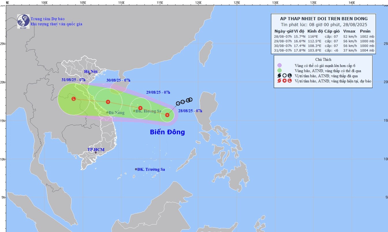
According to the forecast bulletin of strong winds, big waves and thunderstorms at sea at 10:00 a.m. on August 28 of the Vietnam National Center for Hydro-Meteorological Forecasting, at 7:00 a.m. on August 28, the center of the tropical depression was at about 15.7 degrees north latitude; 116.0 degrees east longitude, in the eastern sea area of the northern East Sea.
The strongest wind near the center of the tropical depression is level 6-7 (39-61 km/h), gusting to level 9, moving southwest at a speed of 15 km/h. At Phu Quy station (Lam Dong), there are strong southwest winds of level 5, sometimes level 6; Truong Sa special area has strong winds of level 6.
Forecast of developments in the next 24 hours (day and night of August 28): The northern East Sea area (including Hoang Sa special zone) has strong winds of level 6-7, gusting to level 9. Strong sea; Central and southern East Sea area (including Truong Sa special zone) strong winds of level 6-7, gusts of level 8-9. Strong sea; Area from Lam Dong to Ho Chi Minh City, gusts of level 6, gusts of level 7-8. Rough seas.
Day and night on August 28, the Gulf of Tonkin, the sea area from South Quang Tri to Ca Mau, Ca Mau to An Giang, the Gulf of Thailand, the northern, central and southern East Sea (including the special areas of Hoang Sa and Truong Sa) will have scattered showers and thunderstorms. During thunderstorms, there is a possibility of tornadoes, strong gusts of wind of level 6-7 and waves over 2.0m high.
The risk level of natural disasters due to strong winds at sea is level 2; in the eastern sea area of the northern East Sea, it is level 3. All ships operating in the above areas are at high risk of being affected by tornadoes, strong winds and big waves.