Hong Kong Observatory (China) HKO said it will consider issuing a storm No. 3 warning from 5pm to 7pm on October 20, as Typhoon Fengshen (Phong Than) is getting closer to the city.
Under the combined impact of Typhoon Fengshen and monsoon, the weather will continue to have wind and clouds, with rain in the next few days. Rain will be more frequent on October 21 and early morning of October 22.
Typhoon Fengshen is expected to strengthen into a typhoon and be about 400km from Hong Kong (China) on the morning of October 21, before weakening and moving southwest towards Vietnam.
According to weather forecasts, temperatures in urban areas of Hong Kong (China) are also expected to drop to around 19 degrees Celsius on October 21 and 23.
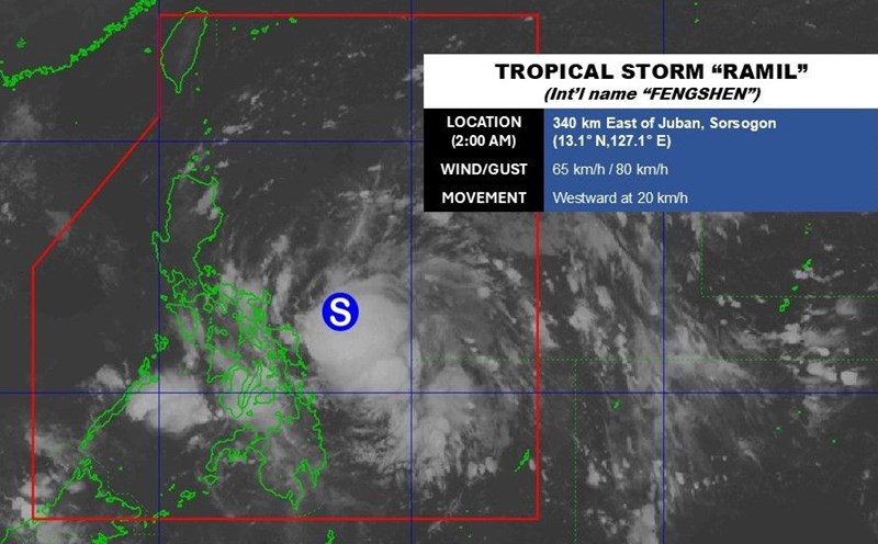
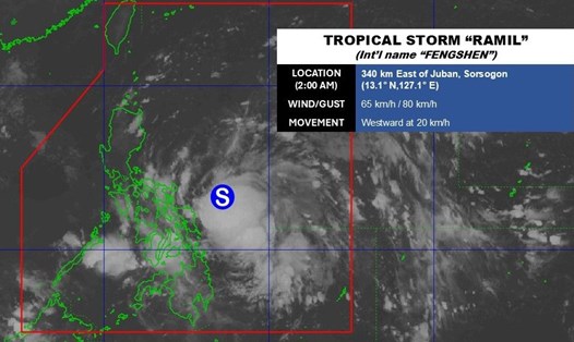
Typhoon Fengshen (called Ramil in the Philippines) killed a family of five on October 19 as the typhoon swept through Luzon.
Local disaster response officials said at least 47,000 people have fled their homes and gone to temporary shelters designated by the government across Southeast Luzon since October 18, while the meteorological agency has warned of the possibility of coastal flooding and landslides.
According to the storm forecast of the Vietnam National Center for Hydro-Meteorological Forecasting (NCHMF), at 4:00 a.m. on October 20, the center of storm No. 12 was at about 17.5 degrees North latitude; 117.2 degrees East longitude, about 540km East Northeast of Hoang Sa Special Zone. The strongest wind near the storm center is level 9 (75-88km/h), gusting to level 11. The storm is moving northwest at a speed of about 25km/h.
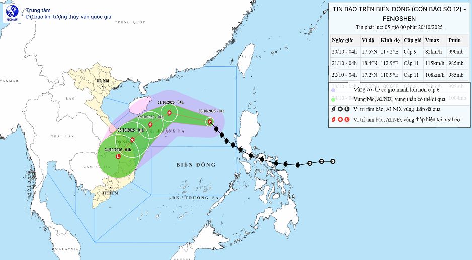
At 4:00 a.m. on October 21, the center of storm No. 12 was at 18.4 degrees North latitude; 112.9 degrees East longitude; about 180km North-Northeast of Hoang Sa Special Zone. The storm is likely to strengthen, reaching level 11, gusting to level 13. The storm is moving west-northwest at about 20km/h.
At 4:00 a.m. on October 22, the center of storm No. 12 was at 17.1 degrees North latitude; 110.9 degrees East longitude; in the northwest sea of Hoang Sa special zone, strong at level 10-11, gusting to level 13. The storm is moving southwest at about 10 km/h.
At 4:00 a.m. on October 23, the center of storm No. 12 was at 15.7 degrees North latitude; 109.0 degrees East longitude; in the sea area from Hue City to Quang Ngai, it was likely to weaken, strong at level 8, gusting to level 10, moving southwest, about 10 km/h.
Thus, from the next 72 to 96 hours, the storm will move mainly in the Southwest direction, traveling about 10km per hour and gradually weakening into a low pressure area.
Due to the impact of the storm, the North East Sea area (including Hoang Sa special zone) has strong winds of level 7-8; the area near the storm's eye has strong winds of level 9-11, gusts of level2; waves 3.0-5.0m high, the area near the storm's eye has 5.0-7.0m high. The sea is rough.
On land, due to the influence of storm circulation and cold air combined with East wind disturbances and terrain effects, from October 22 to 27, the area from Ha Tinh to Quang Ngai is likely to have widespread heavy rain, lasting for many days, locally very heavy rain, high risk of flash floods and landslides in mountainous areas.
Localities need to prepare response plans for flood scenarios on rivers from Quang Tri to Quang Ngai that are likely to reach alert level 3 and exceed alert level 3. Forecast of natural disaster risk level due to storms, floods, and inundation: level 3.