According to storm forecast models on December 16, this is the strongest storm in the North Atlantic since the beginning of winter, with central pressure possibly dropping to the extreme low in a very short time.
The direct cause comes from the interruption and pairing of the cucistic cyclone in the Northern Hemisphere. This phenomenon has pushed the artical cold air waves from Canada and northeastern North America into the Atlantic Ocean, creating ideal conditions for the formation of a cyclone of exceptionally high intensity.
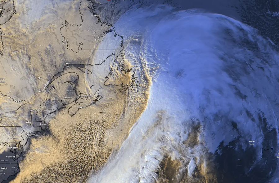
The storm began to develop off the northeastern coast of North America, then moved rapidly northeast, approaching the Newfoundland (Canada) area. During this process, the central pressure of the system drops extremely quickly, far exceeding the standard threshold to be classified as a "bomb cyclone" - a term referring to cyclones in which the central pressure drops by more than 24 mbar within 24 hours.
Meteorological stations in Newfoundland have recorded pressure dropping by more than 5 mbar per hour at various times, suggesting a rapid bombing process. Satellite imagery shows a clear and typical cyclone structure of an extremely fast-strengthening storm, with cloud bands rolling tightly around the center.
Strong cold air flows from the northeastern United States and eastern Canada into warmer Atlantic waters have created a contrast in large temperatures - a key factor in the storm's continued strengthening.
According to atmospheric analysis, the cold core in the upper atmosphere acts as a " motor" sucking energy from the ocean, causing pressure to continue to drop deeply and the wind field to expand rapidly.
During the night and early morning of December 16, strong winds and localized snowstorms appeared in Newfoundland. Forecast models show gusts of wind reaching the intensity of high-level storms, even approaching tropical storm level in some areas of the ocean, with the risk of a stingjet - an extremely strong wind zone forming behind the center of the storm.
The storm is expected to reach its peak intensity by evening, as the center moves south of Greenland and becomes a huge system covering a large part of the North Atlantic. Although it tends to weaken gradually as it approaches Europe, the strong winds are mainly located offshore, so the direct impact on the Western European continent is considered limited.
Meteorological experts say that the early and strong disruption of the tropical cyclones this winter has caused unpredictable fluctuations in weather patterns. The current cold air waves into the ocean could continue to trigger extreme weather phenomena in the coming weeks, making winter weather forecasts, especially at the end of the year, more challenging.


