The latest storm and low pressure information from the Philippine Atmospheric, Geophysical and Astronomical Services Administration (PAGASA) said that a low pressure area is "very likely" to form in the Philippine Forecast Area (PAR) in the coming days and may start affecting the country on November 23.
According to the latest weather update at 2:00 a.m. on November 22 from PAGASA, no low pressure has appeared within the agency's forecast range.
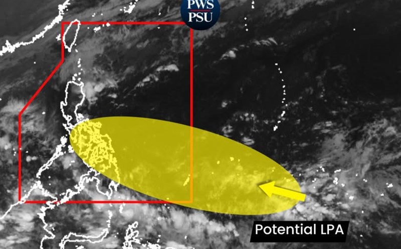
Previously, according to PAGASA's short-term forecast on November 21, a new low pressure may form in the southeast of the PAR between November 21 and 27.
"Currently, this system is likely to become a low pressure area. The closest time the low pressure can affect the Philippines, especially northeastern Mindanao and Eastern Visayas, is on Sunday afternoon (November 23). This low pressure will have the most obvious impact starting from November 24 and the following days, said PAGASA weather forecaster John Manalo.
If it forms within the PAR and strengthens into a storm, it will be locally named Verbena.
Philippine weather forecasters note that the new low pressure may affect the weather in the Philippines and enter the East Sea during the week of November 28 to December 4.
While the system is likely to become a storm Verbena entering the South China Sea and could become a storm No. 15 in the South China Sea, another low pressure is forecast to form east of the Philippine weather agency's monitoring area during the forecast period. However, this low pressure near the Philippines is unlikely to strengthen into a storm.
There are currently many weather systems continuing to cause rain across areas of the Philippines. PAGASA said wind shear caused cloudy skies with scattered showers and thunderstorms in the Cordillera, Cagayan, Isabela, Quirino and Nueva Vizcaya regions.
The northeast monsoon causes cloudy skies with showers in Batanes and cloudy to cloudy skies with localized showers in Ilocos.
The Intertropical Convergence Zone (ITCZ) causes cloudy skies with scattered showers and thunderstorms in Caraga, Northern Mindanao, Davao, Soccsksargen and Palawan and cloudy skies with scattered showers or thunderstorms in other parts of Mindanao.
Quezon and Aurora recorded cloudy skies with scattered showers and thunderstorms, while the rest of the Philippines were cloudy with scattered showers or thunderstorms due to easterly winds.
Philippine weather forecasters warn that flash floods or landslides may occur in some areas due to these weather conditions.