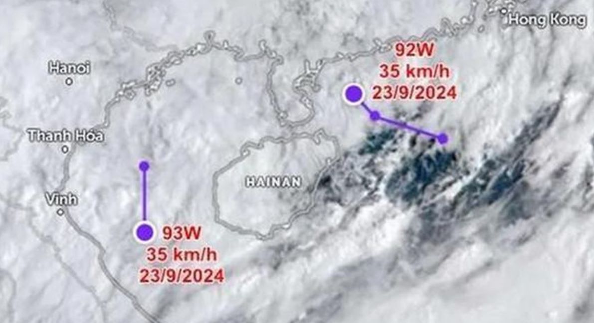
According to the latest storm information from the Joint Typhoon Warning Center (JTWC) of the United States, at 7:00 a.m. on September 23, the first low pressure area named 92W was near Hainan Island (China). The strongest wind near the center of the low pressure area was 35 km/h, moving in a west-northwest direction, south of China.
According to JTWC's storm forecast, the possibility of low pressure 92W strengthening into a tropical depression or storm in the next 24 hours is low.
Regarding the second low pressure named 93W, JTWC assessed that the low pressure appeared right in the Gulf of Tonkin, with the strongest wind near the center of the low pressure being 35 km/h, and is likely to approach Central Vietnam.
JTWC forecasts that the possibility of low pressure 93W strengthening into a tropical depression or storm in the next 24 hours is also low.
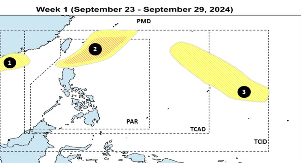
On the same day, September 23, the Philippine Atmospheric, Geophysical and Astronomical Services Administration (PAGASA) forecast that during the week of September 23-29, 2024, up to three depressions are expected to appear near the Philippines.
Low pressure 1 (93W as designated by JTWC) is present in the PAGASA Monitoring Domain (PMD), with the possibility of strengthening into a storm.
Low pressure 2 (92W as designated by the JTWC) formed in the northeastern part of the Philippine forecast area (PAR) boundary, with a low to moderate chance of strengthening.
Low pressure 3 is expected to appear east of the Tropical Cyclone Information Domain (TCID) of the Philippines, with the possibility of strengthening into a tropical depression.
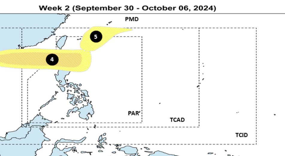
During the week of September 30 to October 6, two other low pressure systems are expected to form near the Philippines. Low pressure 4 is expected to form near the northeast of Luzon Island, moving westward, with the potential to strengthen into a tropical depression.
Low pressure 5 is expected to form north of PAR, with the potential to strengthen into a tropical depression or storm.
Meanwhile, according to the weather forecast of the Vietnam National Center for Hydro-Meteorological Forecasting, in the past 24 hours (from 11am on September 22 to 11am on September 23), the mountainous and midland provinces of the North and the provinces from Thanh Hoa to Thua Thien Hue had heavy rain, some places had very heavy rain such as: Km46 100mm (Son La); Lung Van 147mm (Hoa Binh); Cho Trang 364mm (Nghe An); Khe Co Lake 268mm (Ha Tinh); Trong Hoa 121mm (Quang Binh); Binh Dien Hydropower Plant 106mm (Thua Thien Hue)...
Soil moisture models show that some areas in the above provinces are close to saturation (over 85%) or have reached saturation.
Rain warning in the next 3-6 hours, the mountainous provinces of the North will continue to have rain with common rainfall less than 10mm, some places over 20mm; The provinces of the Northern Delta, midlands and Thanh Hoa will have rain from 10-20mm, some places over 50mm; The provinces from Nghe An to Quang Binh will have rain from 20-40mm, some places over 80mm; Thua Thien Hue from 10-30mm, some places over 50mm.
In the next 6 hours, there is a risk of flash floods on small rivers and streams, landslides on steep slopes in many districts. Warning level of natural disaster risk due to flash floods, landslides, land subsidence due to heavy rain or water flow is at level 1.