The latest storm information on July 21 from the US Navy's Joint Typhoon Warning Center predicts that Typhoon Wipha will gradually strengthen as it moves through the Gulf of Tonkin.
JTWC forecasters pointed out that Wipha moved on relatively flat terrain when it made landfall in China on July 20, helping the system stabilize quite well as it entered the Gulf of Tonkin.
At sea, warm ocean waters will promote the storm's intensification before making landfall in Vietnam.
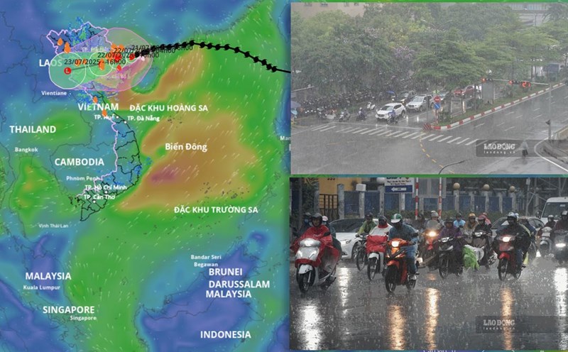
Notably, Typhoon Wipha maintained its westward movement, rather than southwestward, causing the storm's path to shift about 56 km north of the original forecast. This means Wipha has less time in the Gulf of Tonkin before making landfall in Vietnam.
JTWC forecasters said that Typhoon Wipha is likely to make landfall in the next 24 hours in the vicinity of Hai Phong or offshore islands such as Cat Ba.
Typhoon Wipha has made landfall in southern China since July 20, causing flash floods and landslides. Heavy rain was recorded in Guangdong province, China when the storm made landfall. Previously, the typhoon affected Hong Kong (China), cutting down trees, paralyzing flights, forcing nearly 280 people to evacuate.
China's National Weather Service said that heavy rain is expected to continue in coastal areas of China such as Guangdong, Guangxi, Hainan and Fujian until the morning of July 22, accompanied by flash flood warnings, landslides and the risk of gusts of wind.
China's typhoon forecasters also expect Wipha to strengthen before making landfall in Vietnam on July 22.
Typhoon No. 3 in the Wipha East Sea started from a low pressure in the sea east of the Philippines last week, causing heavy rain to the northern Philippines. In the Philippines, Typhoon Wipha is known as Crising. The storm caused $3.8 million in damage to infrastructure and killed at least five people.
With a long coastline along the East Sea, Vietnam is easily affected by storms. Last year, super typhoon Yagi claimed about 300 lives and caused $3.3 billion in damage.
According to US typhoon forecasters, after making landfall in Vietnam, Typhoon Wipha will weaken and continue to move westward, entering northern Laos.
Faced with the possibility of being affected by the latest storm in the East Sea, on July 20, the Thai Meteorological Department issued a warning for heavy to very heavy rain across the country. Bangkok is expected to be hit hard, with a 70 percent chance of thunderstorms throughout the day.
According to the forecast, some areas of Thailand will see heavy rain, with the heaviest rain in Bueng Kan, Nakhon Phanom, Chanthaburi, Trat and Ranong. People in these areas are advised to be highly vigilant against flash floods.