The latest storm information from the Philippine weather agency PAGASA released at 11:00 on November 12 said that Typhoon Toraji (local name: Nika) is 225km northwest of Laoag City, Ilocos Norte, Philippines or 315km west of Calayan, Cagayan, Philippines.
Storm No. 8 in the East Sea is having maximum sustained winds of 95km/h near the center, gusts of up to 115km/h. The storm is currently moving northwest at a speed of 10km/h.
According to the forecast track, Typhoon Toraji will continue moving in the East Sea and leave the Philippine PAR forecast area on the afternoon of November 12.
Philippine typhoon forecasters say that Typhoon Toraji will weaken in the coming days, becoming a low pressure area over the sea near southern China. However, this storm will continue to be a strong storm throughout its movement through the PAR region of the Philippines.
Regarding the impact of Typhoon Toraji, the Hong Kong Meteorological Station (China) said that during its journey in the East Sea, Typhoon Toraji will approach Hong Kong (China) about 800km.
Toraji will move towards the vicinity of the western coast of Quang Dong province to the Chau Giang river mouth in the next few days. Under the combined impact of storm Toraji and the northeast monsoon, the wind in this area will gradually strengthen with showers" - the bulletin stated.
The Hong Kong Meteorological Station (China) forecasts that Typhoon No. 8 in the East Sea may be " Relatively close" to the area near the mouth of the Zhuang Rivers on November 14 but may have weakened at this time.
The impact of storm No. 8 in the East Sea Toraji on Hong Kong (China) was recorded shortly after storm No. 7 Yinxing had weakened.
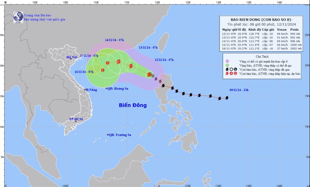
The latest East Sea storm news from the Vietnam National Center for Hydro-Meteorological Forecasting said that at 7:00 a.m. on November 12, the center of storm No. 8 was at about 18.5 degrees North latitude; 118.7 degrees East longitude, in the eastern sea of the northern East Sea. The strongest wind near the storm center is level 9-10 (75-102km/h), gusting to level 12. Storm No. 8 in the East Sea moves northwest, at a speed of about 10km/h.
The center's forecast for the next 24 to 72 hours clearly states that at around 7am on November 13, storm No. 8 was in the eastern sea, the northern East Sea area at level 9-10, gusting to level 12. By 7:00 a.m. on November 14, the storm was in the northern sea area, the northern East Sea area, with the intensity gradually weakening - level 8, gusting to level 10. By 7:00 a.m. on November 15, storm No. 8 gradually weakened into a tropical depression in the northwest of the northern East Sea.


