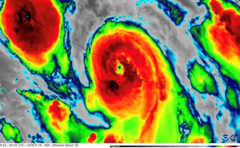
Hurricane Helene is expected to make landfall in the US on September 26 as a Category 4 storm with winds of up to 210 km/h, according to the latest storm news from USA Today.
Hurricane Helene is expected to be one of the most "intensive" and rapidly intensifying storms in history. Helene's rapid intensification from a tropical depression with the potential to strengthen into a Category 3 tropical storm on September 24 is an unprecedentedly fast development for a system forecast by the US National Hurricane Center, according to USA Today.
"They have never forecast a major hurricane in 60 hours for a low-pressure system below tropical storm level. The entire forecast is essentially faster than any of the 36 to 48 hours for a tropical depression," said Sam Lillo, a meteorologist and software engineer at DTN Weather.
Helene is expected to bring heavy rain as it makes landfall in the US mainland due to the Fujiwhara effect, according to USA Today. The Fujiwhara effect - describing two nearby storms attracting each other - is considered the most delicate "dance" of meteorology.
Hurricane models show that as Helene moves through Florida into the southeastern United States, "the storm will experience Fujiwhara interaction with the trough over the Ozarks," the National Weather Service in Shreveport, Louisiana, said.
"This roughly means that the remnants of Helene after making landfall in the US will move near the trough in the Ozarks. The remnants of the storm will circulate around the trough before being absorbed by the trough to form a larger closed trough," the weather service said.
"This phenomenon is extremely rare at this latitude," noted KATV meteorologist James Bryant.
Forecasters say the Fujiwhara interaction between Helene and the Ozarks trough will produce heavy rain, with the potential for flooding in parts of the central and southern United States and Ohio over the next few days.
The Fujiwhara effect occurs when two storms move close enough together to form a fierce "dance" around a common center. Experts say the effect occurs when the storms are about 1,500km apart.
The phenomenon of the double storm was first confirmed by Japanese meteorologist Sakuhei Fujiwhara after observing two interactive storms in the Pacific Ocean in 2021.
The Fujiwhara effect could make forecasting more difficult. Normally, in weather forecasts, predicting the location of a storm making landfall is difficult. However, Fujiwhara interaction may make this process more difficult.
The problem is how strong the storm area or secondary depression will be. If the depression strengthens, it will push Helene closer to the narrow strip of land in Florida.
If the depression weakens, Helene could have more impacts across Florida's Big Bend. Forecasters will see these details clearer in the next 24-36 hours.