According to the National Center for Hydro-Meteorological Forecasting, last night and this morning (October 19), the area from Thanh Hoa to Quang Ngai had scattered showers and thunderstorms, locally heavy to very heavy rain.
Rainfall from 7pm on October 18 to 8am on October 19 locally has monitoring stations measuring over 70mm such as: Mai Lam station (Thanh Hoa) 99.6mm; Nong Truong 15 station (Nghe An) 158.4mm; Suoi Luong station (Da Nang) 73.2mm,...
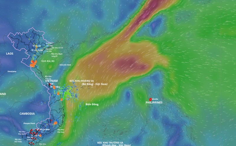
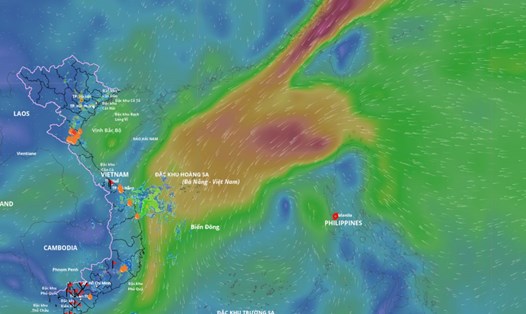
From the evening to the end of the night of October 19, the area from Nghe An to Quang Ngai will have moderate rain, heavy rain with common rainfall of about 30 - 60mm, locally very heavy rain over 100mm. Warning of the risk of heavy rain with rainfall greater than 80mm within 3 hours. The risk level of natural disasters due to heavy rain, tornadoes, lightning, and hail is level 1.

According to Mr. Mai Van Khiem - Director of the National Center for Hydro-Meteorological Forecasting, from October 20 to October 21, heavy rain in the above area tends to decrease compared to October 19. However, from October 22, the rain is likely to increase again.
"From October 22 to October 27, due to the influence of storm No. 12 and cold air, from October 22 to 27, the area from Ha Tinh to Quang Ngai is likely to have widespread heavy rain. Localities need to prepare response plans for flood scenarios on rivers from Quang Tri to Quang Ngai that may reach alert level 3 and above alert level 3" - Mr. Khiem said.
According to the representative of the meteorological agency, the current rainfall scenarios as well as the impact of storms on the mainland of Vietnam still depend heavily on the development of the cold air. Therefore, it is necessary to closely monitor the simultaneous developments of the storm's path and the impact of cold air.
Heavy rain is likely to cause flooding in low-lying areas, urban areas, industrial parks; flash floods on small rivers and streams; landslides on steep slopes.
Real-time warning information for areas at risk of flash floods and landslides is provided online on the website of the Department of Hydrometeorology at: https://luquetsatlo.nchmf.gov.vn and in a separate bulletin warning of flash floods and landslides.
Regarding the hydrological situation, currently, floods on rivers in Hue city are fluctuating above alert level 1. The water level at 1:00 p.m. on October 19, 2025, on the Bo River at Phuoc station was 2.52 m, 0.48 m lower than alert level 2; on the Huong River at Kim Long station was 1.06 m, 0.06 m higher than alert level 1.
From now (October 19) to October 20, floods on rivers in Hue city will continue to fluctuate between alert level 1 and alert level 2.
There is a high risk of flooding in low-lying areas along rivers, flash floods and landslides on steep slopes in Hue city.
The warning level of natural disaster risk due to floods is level 1. Floods on rivers and streams can cause flooding in low-lying areas along rivers, affecting waterway transportation, aquaculture, agricultural production, people's lives and socio-economic activities.
The interaction of cold air and storms is one of the types of interaction with many scenarios. If the storm comes first, the cold air comes later or the storm and the cold air will cause a lot of rain, but in the case of the cold air coming first, then the new storm comes, the rain is not too heavy.