Environment

Storm No. 1 gusting at level 10 is moving very slowly, continuing to cause heavy rain
|
Typhoon No. 1 is still maintaining intensity level 8, gusting level 10 in the southern area of Guangxi province (China), 120km north-northeast of Mong Cai (Quang Ninh).

Warning to provinces and cities with heavy rain today, in some places over 150mm
|
On July 5, the Northeast region, Lai Chau, Dien Bien, Son La and Lao Cai provinces will have moderate to heavy rain; meanwhile, the Central and Southern regions will have scattered showers and thunderstorms.

Storm No. 1 has moved to China but still causes heavy rain, dangerous weather
|
Typhoon No. 1 has entered southern Guangxi province (China), but the typhoon's circulation continues to cause dangerous weather in the Northeast region.

Weather today July 5th: Northern region has places with heavy to very heavy rain due to the circulation of storm No. 1
|
Weather today July 5, the Northeast region has moderate rain, heavy rain, and very heavy rain in some places due to the influence of storm No. 1's circulation.

Forecast of heavy rain in the area today July 5 due to storm No. 1 circulation, in some places over 300mm
|
Due to the circulation of storm No. 1, today July 5, the Northeast region continues to have moderate to heavy rain, with very heavy rain in some places. Quang Ninh coast has strong winds at level 6-7, gusts at level 9-10.

Requesting dike protection, protecting key dyke areas as Wipha strengthens in the East Sea
|
Provinces and cities must check, review and implement in practice the dike protection plan, protecting key dyke points in the face of storm No. 3.
Storm No. 3 accelerates to rapidly strengthen, forecasting the time of heavy rain
|
According to the representative of the meteorological agency, due to the impact of storm No. 3 Wipha, from July 21, the North and North Central regions need to be on guard against heavy rain.

Developments affecting storm No. 3 to rain in the Southern region
|
HCMC - According to the Southern and Central Highlands Hydrometeorological Station, there will be scattered showers and thunderstorms in the afternoon and evening.
Forecast of 5 provinces most affected by storm Wipha, warning of dangerous weather
|
According to the representative of the meteorological agency, Quang Ninh, Hai Phong, coastal areas of Hung Yen province, Ninh Binh, Thanh Hoa are forecast to be affected by the strongest storm Wipha.

Forecast of the time when the severe heat will end in the North
|
According to the meteorological agency, the severe heat in the North will continue until today, July 19.
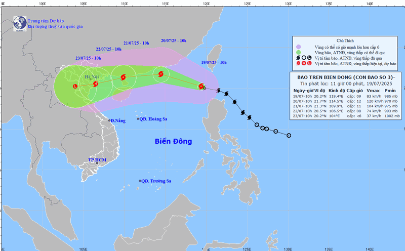
Forecast of the most affected area of storm No. 3 Wipha in the East Sea
|
It is forecasted that in the next 24 hours, the most affected area of storm No. 3 Wipha will be the northeastern sea area of the northern East Sea, the sea will be very rough.
Storm Wipha enters the East Sea, many mainland areas are ordered to be checked, ready to evacuate people
|
The mainland of the Northern and North Central regions is required to review and be ready to evacuate people from unsafe houses due to the impact of storm No. 3.
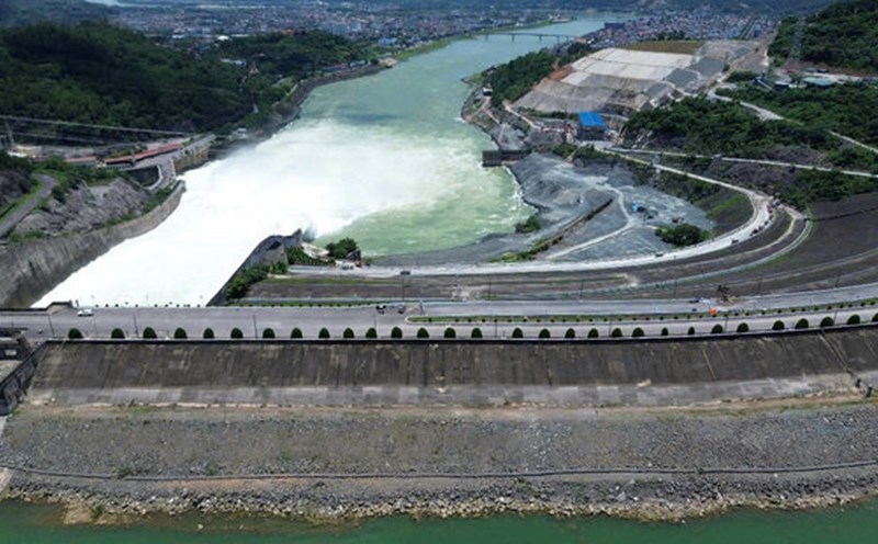
Order to close 2 consecutive bottom spillways of Hoa Binh hydroelectric reservoir, 6 provinces and cities must ensure safety
|
The Ministry of Agriculture and Environment has just issued a telegram on closing the bottom spillway of Hoa Binh Lake.

Forecast of the hottest hot spots in the next 2 days and the end time
|
According to the meteorological agency, the mountainous areas west of Nghe An to Hue, Da Nang, the eastern areas of the provinces from Quang Ngai to Dak Lak and Khanh Hoa are the focus of hot weather.

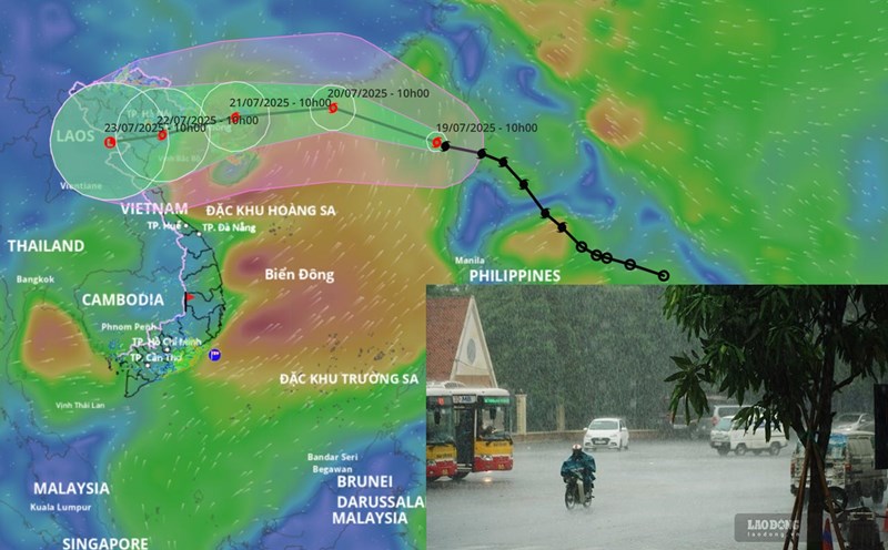
Latest forecast of the path of storm No. 3 Wipha in the next 24 hours
|
According to the meteorological agency, in the next 24 hours, storm No. 3 Wipha is forecast to move west-northwest, move deep into the East Sea and continue to strengthen.

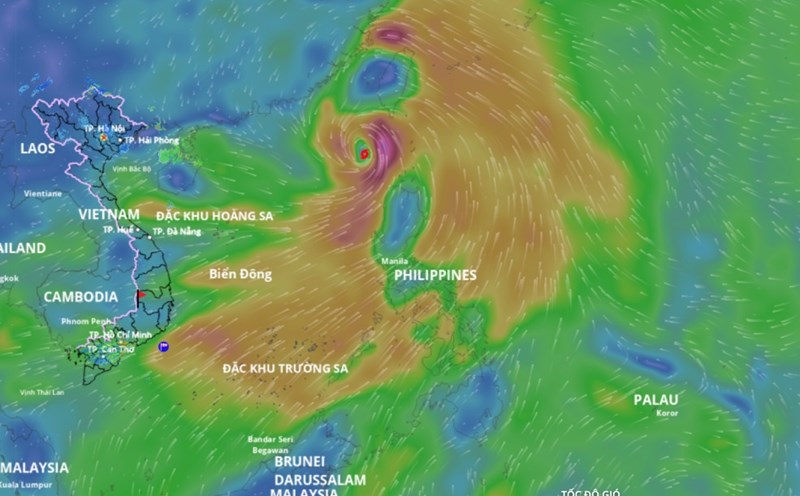
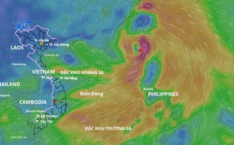
Storm Wipha has headed straight to the East Sea to become storm No. 3, about to continuously strengthen
|
According to the meteorological agency, this morning (September 19), Typhoon Wipha entered the northeastern sea of the northern East Sea, becoming the third storm of 2025.

Latest forecast of the time when Typhoon Wipha will cause heavy rain and strong winds in the North
|
According to the representative of the meteorological agency, with the current scenario, it is forecasted that around July 21, storm Wipha will begin to cause strong winds in the coastal area and widespread heavy rain in the North.

Weather today, September 19: Forecast for heavy rain in the South and North in the evening
|
Weather today 19.7, the North will have hot and sunny days, scattered showers and thunderstorms in the late afternoon. In the South, there will be heavy rain in some places in the afternoon and evening.

Morning in the West 19.7: At the beginning of the rainy and stormy season, Ca Mau subsided, landslides in many places
|
Morning in the West 19.7: Husband stabs wife to death after an argument, receives 8 years in prison; At the beginning of the rainy and stormy season, Ca Mau has landslides, subsidence in many places, etc.

Forecast of when Typhoon Wipha will reach its strongest intensity, causing heavy rain on land
|
According to the representative of the meteorological agency, in the next 48 hours, Typhoon Wipha will reach its strongest intensity of about level 11 - 12 when it approaches the Lusian Peninsula (China).