The latest typhoon news on July 8 from Xinhua News Agency said that China's Ministry of Water Resources has activated a level 4 emergency response to flooding in Zhejiang and Fujian provinces as Typhoon Today is approaching.
leo, (formerly storm No. 2 in the East Sea), made landfall in Taiwan (China) on the night of July 6 and headed out to sea on the morning of July 7.
Chinese typhoon forecasters said that typhoon Today made its second landfall in the coastal area between Taizhou, Zhejiang Province and Ningbo, Fujian Province from the afternoon to evening of July 8.
The storm will bring heavy rain to affected areas until July 10, with some areas in southeastern Zhejiang, the eastern coast of Fujian and Jiangxi Province expected to have heavy to extremely heavy rain.
Rivers, including the Tien Duong River in Zhejiang and its dependencies, are expected to have significantly rising water levels. China's Ministry of Water Resources warned of the possibility of water rising above warning levels on some medium and small rivers in the region and warned of the risk of high flash floods in mountainous areas.
The latest typhoon information from the Philippine Atmospheric, Geophysical and Astronomical Services Administration (PAGASA) said that Typhoon Today is outside the Philippine Forecast Area (PAR) and is expected to move towards northeastern China before leaving PAGASA's PMD forecast area this week.
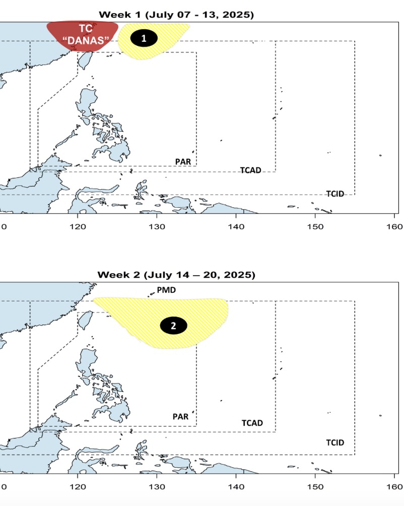
According to Philippine weather forecasters, right after storm Today, 2 low pressure areas near the East Sea are forecast to form. The first low pressure is expected to appear in the northeastern part of PAR with the possibility of strengthening into a low storm this week from now until July 13.
Meanwhile, the second low pressure near the East Sea is expected to appear between August 14 and 20. Forecast models show the depression forming at the northeastern boundary of PAR and PAGASA's TCAD forecast area. Similarly, the new low pressure is unlikely to strengthen into a storm during the forecast period.
The storms that will occur this year will not be as strong as those that entered or developed within the Philippine Area of Responsibility (PAR) last year.
Over the weekend, Philippine Minister of Science and Technology Renato solidum and PAGASA Deputy Director Mar Villafuerte said that storms in the Philippines this year will not be as strong as those that formed or entered the PAR last year. solidum said last year's storms were stronger due to the impact of La Nina.
During the La Nina period, the waters around the Philippines will have warmer sea surface temperatures, which fuel storms, Villafuerte explains. He expects 10 to 18 more typhoons to hit the Philippines this year, following Typhoon Today (known as Bising in the Philippines). He also said there is a chance of one to two storms making landfall or forming within the PAR in July.