The latest storm and low pressure information on July 3 from the Philippine Atmospheric, Geophysical and Astronomical Services Administration (PAGASA) said that a tropical depression is affecting the weather in the northeastern boundary of PAGASA's PMD forecast area.
At the same time, a low pressure near the East Sea is active inside the Philippine Forecast Area (PAR), east of Northern Luzon, Philippines. The low pressure is marked as 1 on PAGASA's forecast map and is likely to strengthen into a storm during the week of July 2 to 8.
Typhoon forecast models in the Philippines show that the depression will continue to move north of the PAR boundary during the week of July 9 to 15.
At the same forecast period, another low pressure near the East Sea is likely to appear in the northeastern boundary of PAR and TCAD. The low pressure marked as No. 2 is unlikely to strengthen into a storm.
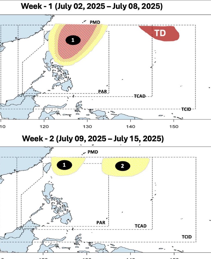
Regarding the low pressure near the East Sea in the PAR, the Joint Typhoon Warning Center (JTWC) of the US Navy calls this low pressure Invest 98W.
Invest 98W is located in the northeast of Luzon, Philippines. The low pressure is forecast to have a moderate chance of strengthening into a storm in the next 24 hours. The maximum sustained wind speed of this depression is about 30-35 km/h.
Analysis by JTWC forecasters shows that the environment is favorable for low pressure Invest 98W to develop, with weak low-level wind shear, sea surface temperatures from 30-31 degrees Celsius. All models show the low pressure moving gradually northward over the next few days.
Regarding the tropical depression at the northeastern boundary of PAGASA's PMD forecast area, JTWC named the system tropical depression 04W. The JTWC said that 04W is 1,361 km southeast of Yokosuka, Japan and has been moving north-northeast at a speed of 15 km/h over the past 6 hours. It is forecasted that 04W will continue to move north - northwest in the next 2 days.
Tropical Depression 04W is forecast to strengthen into a tropical storm on July 3, maintain its intensity until July 4 and accelerate to maximum intensity, with winds of up to 110 km/h on July 5 and then weaken immediately.
The Japan Meteorological Agency (JMA) has also started monitoring the tropical depression, which the JTWC named 04W, since July 2. The JMA named the depression A. The depression is moving north-northwest at a speed of 15 km/h, with maximum sustained winds of 54 km/h and gusts of 83 km/h.
The 2025 northwest Pacific typhoon season has seen two typhoons in June, including Wutip and Sepat. The next storm name on the list of typhoon names after Wutip and Sepat is Mun. Typhoon Mun is contributed by Micronesia. Mun is a word in the language of the residents of the Yap islands of the Federated States of Micronesia in the western Pacific, for example, June.