The latest storm and low pressure information on July 9 from the Philippine Atmospheric, Geophysical and Astronomical Services Administration (PAGASA) said that there are forecasts of 3 consecutive low pressure areas around the East Sea from now until July 22.
The bulletin said that the low pressure forecast near the East Sea will appear in the PAGASA PMD forecast area (outside the Philippine PAR forecast area) during the week from July 9 to July 15. This low pressure near the East Sea is unlikely to strengthen into a storm.
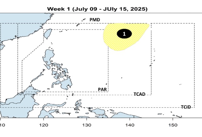
On July 9, PAGASA is monitoring a low pressure area outside the PAR area. PAGASA weather expert Loriedin Dela Cruz-Galicia said the low pressure is about 1,685 km east of Northern Luzon, with a very small chance of entering the PAR and strengthening into a tropical depression. This low pressure is not expected to directly affect the weather in the Philippines.
Philippine typhoon and low pressure forecast models show that during the week from July 16 to 22, two consecutive low pressure areas are forecast to form around the East Sea. The low pressure area near the East Sea is likely to appear in the eastern border area of PAGASA's TCAD forecast area. This low pressure is expected to have a very wide area of influence. After forming in TCAD, this low pressure will enter the eastern part of PAR and is unlikely to strengthen into a storm.
Also during the forecast period, a new low pressure is expected to form in the East Sea. This low pressure in the East Sea is likely to form in the northern part of the East Sea, within the northwest boundary of the PAR. This low pressure in the East Sea has a very large coverage area in the north of the East Sea, in the direction of expanding towards Vietnam. It is forecasted that this low pressure is unlikely to strengthen into a storm between July 16 and July 22.
According to PAGASA data, typhoons in the Philippines in July typically have three common paths of movement. First, the storm approaches the Philippines but does not make landfall but loops north of the PAR, moving towards Taiwan (China) or Japan. Second, the typhoon makes landfall in the northernmost islands of the Philippines, moving towards China or Hong Kong (China). Third, the storm makes landfall in the Philippines in the northern or central part of Luzon, then enters the East Sea and heads towards Vietnam.
According to PAGASA's July typhoon forecast, two to three typhoons will form or enter the PAR area. Typhoons in July typically pass through parts of Luzon or around the northeast of the Philippines.
In early July, tropical depression Bising formed off the coast of Northern Luzon and then strengthened into storm Bising (international name storm Today). Bising formed three weeks after Tropical Depression Auring became the first named system in the Philippines this year to appear on July 11. The next storm name for PAGASA's 2025 typhoon season is Crising.