The latest storm and low pressure information from the Philippine Atmospheric, Geophysical and Astronomical Services Administration (PAGASA) said that low pressure 09f has formed outside the Philippine Forecast Area (PAR).
The new low pressure is 1,345km northeast of Mindanao. Forecasters say that 09f has a moderate chance of strengthening into a tropical depression within the next 24 hours.
Previously, at 8:00 p.m. on September 21, low pressure 09f was about 1,525 km east of northeast Mindanao and was assessed by PAGASA as unlikely to strengthen into a tropical depression in the next 24 hours.
The new low pressure has formed amid super typhoon Ragasa (known as Nando in the Philippines) affecting the weather in the Philippines.
Due to the impact of the super typhoon, some localities in Luzon have given students a day off on September 22.
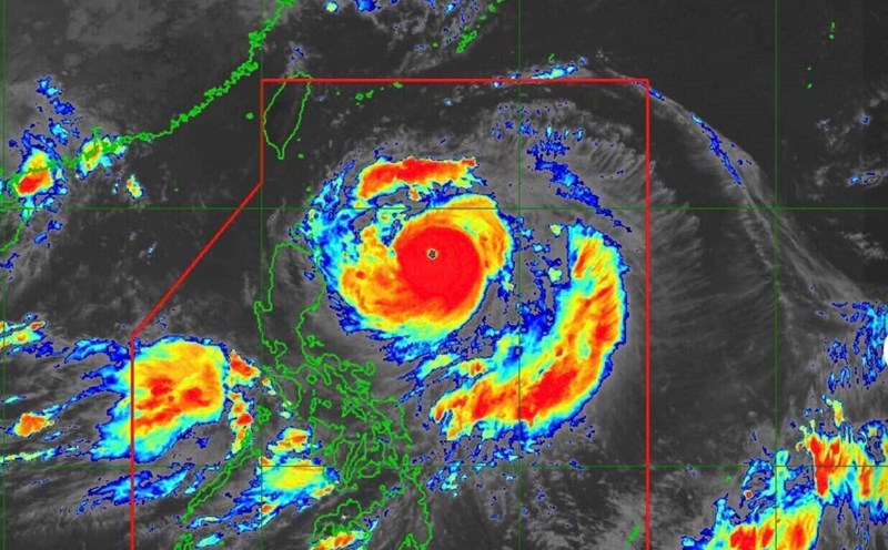
Super typhoon Ragasa has a solid structure, so forecasters from the Taiwan Meteorological Administration (CWA) say it is likely to strengthen.
The storm is currently forecast to move westward across the Bashi Strait and make landfall on the southern coast of China, southwest of Macau (China).
Super Typhoon Ragasa is expected to make the strongest impact on Taiwan (China) on September 22 and 23.
The CWA also said another super typhoon - Neoguri - is active in the northwest Pacific Ocean, about 3,110km northeast of Taipei and east of Japan. Neoguri is moving northwest to north, with sustained winds of 184 km/h and gusts of up to 227 km/h.
Typhoon historical data shows that Typhoon Hinnamnor in September 2022 was the last typhoon to make landfall in Taiwan (China) with winds of up to 198 km/h and a storm radius of 300 km. Typhoon Kong-rey in 2024 has slightly weaker winds, 190.8 km/h but a wider radius, 320 km.
In contrast, Typhoon Krathon in 2024 will have winds of 198 km/h with a smaller radius of 220 km, while Typhoon Chanthu in 2021 will have winds of 208 km/h and an area of influence of only 200 km.