Typhoon Ragasa, the 14th tropical storm to hit the Philippines in 2025 (local name Nando), is threatening Northern Luzon and Central Luzon.
The latest storm information from the Philippine Atmospheric, Geophysical and Astronomical Services Administration (PAGASA) said that at 4:00 a.m. on September 21 (local time, or 3:00 a.m. on September 21, Vietnam time), the center of the storm was at about 17.9 degrees North latitude, 127.5 degrees East longitude, 610km east of Tuguegarao City, Cagayan.
Maximum winds near the center of the storm are 175 km/h, gusting up to 215 km/h, super typhoon level with central pressure of 935 hPa. The super typhoon has maximum sustained winds of 185 km/h or more.
The storm is moving northwest at a speed of 15 km/h. The storm's wind radius extends up to 530km from the center of the storm.
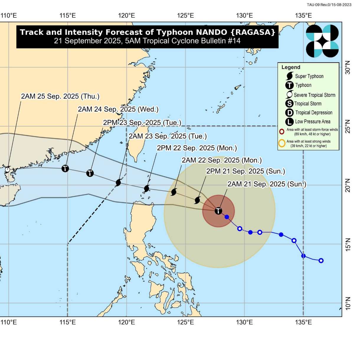
PAGASA said it could raise the warning of strong winds to the highest level (level 5) in many areas of Northern and Central Luzon, forecasting heavy to very heavy rain, high risk of flash floods, landslides and coastal rises.
Not only causing direct impact, the storm also strongly sucks the southwest monsoon, causing many areas, including the capital Manila, to record severe thunderstorms.
The Philippine Civil Defense Office (OCD) said on the evening of September 20 that it had urgently evacuated 111 households (about 380 people) in Ilocos, Central Luzon and Calabarzon to avoid the risk of storms and heavy rain.
OCD affirmed that it is prioritizing ensuring the safety of people's lives and deploying the supply of essential goods to evacuation areas.
Meanwhile, according to the latest storm information from the Vietnam National Center for Hydro-Meteorological Forecasting, by 01:00 on September 22, the storm will move in a West-Northwest direction, 15 km/h, likely to strengthen, located at about 19.0 degrees North latitude, 124.4 degrees East longitude, 240km East Northeast of Luzon Island. Strong winds of level 14-15, gusting over level 17.
At 01:00 on September 23: Continue to the West Northwest direction, 15-20 km/h, reach level 16, gust above level 17, at about 20.3 degrees North latitude, 120.3 degrees East longitude, in the sea north of Luzo Island. Dangerous area: North latitude 18.0 degrees North latitude, East longitude 118.0 degrees East longitude. Natural disaster risk level: Level 4 (eastern sea area of the North East Sea).
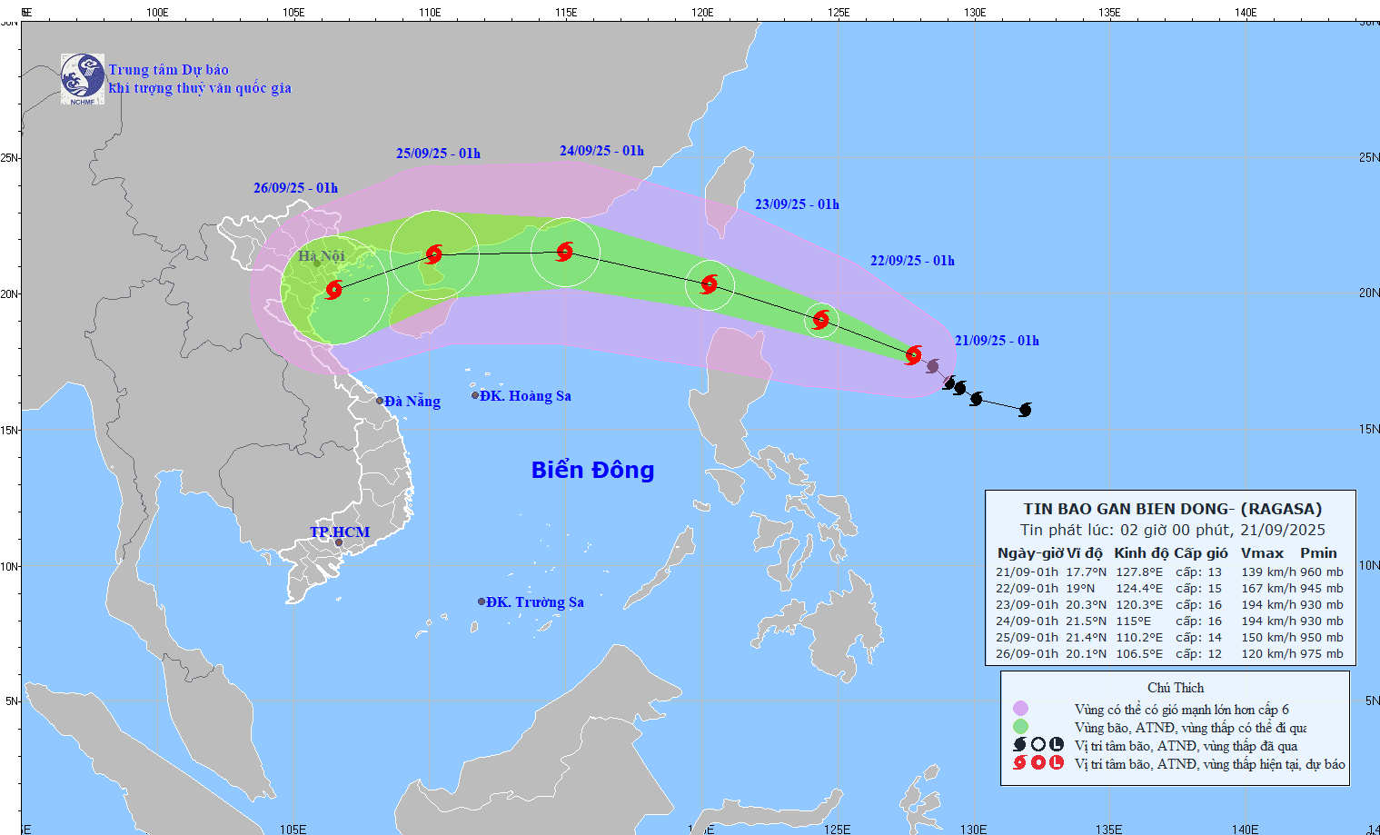
At 01:00 on September 24: The storm accelerated at 20-25 km/h, entering the East Sea, located at about 21.5 degrees North latitude, 115.0 degrees East longitude, 140km southeast of Hong Kong (China). The wind force remains at level 16, gusting over level 17.
Dangerous area: North latitude 18.0 degrees North latitude, East longitude 113.0 degrees East longitude. Natural disaster risk level: level 4 (Northern East Sea area).
Forecast in the next 72-120 hours: The storm is expected to continue moving west, then change to West Southwest at a speed of about 20 km/h and gradually weaken.
From the afternoon of September 22, the Northeast of the East Sea will have strong winds of level 6-7, gusting to level 11. That same night, the wind increased to level 10-13; near the storm center, level 14-16, gusting above level 17. Waves are 4-8 m high, the area near the storm's eye can exceed 10 m, the sea is very rough.
Ships are not allowed to enter the danger zone due to the extremely high risk of gusts of wind, thunderstorms and large waves.