According to the FOX Weather Forecast Center on July 13, the low pressure area is expected to form off the southeastern coast of the United States, then move across northern Florida and into the Gulf of Mexico this weekend.
With the potential to stay for several days in the warm waters of the Gulf of Mexico and the western Atlantic, the system is being closely monitored by the US National Hurricane Center (NHC) for the potential to develop into a tropical storm.
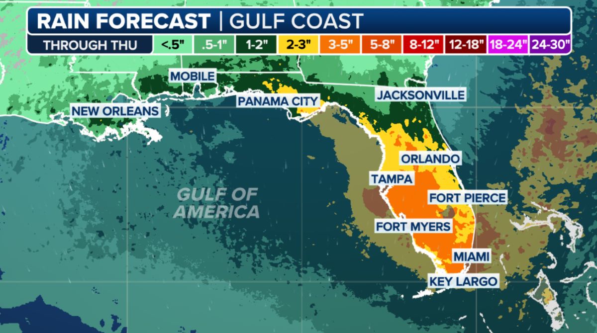
Although there are no signs of significant strengthening in the short term, this slow-moving weather system is expected to bring widespread heavy rainfall to Central and South Florida, especially from now until mid-week.
Total rainfall for the week could reach 75-125 mm in the southern part of the I-4 federal highway, with some strong thunderstorms could bring rain to a speed of 25-75 mm per hour, increasing the risk of localized flooding.
The NHC hurricane bulletin notes: Whether the system develops into a hurricane or not, heavy rainfall is still likely to hit the Florida peninsula and the Southeast coastal areas of the United States from mid- to late weekend.
Pay attention to the possibility of storm formation as the system moves into warm waters east of the Gulf of Mexico. Some typhoon forecast models show that the system is likely to develop weakly into a tropical depression or low-level storm, depending on factors such as wind shear and the time the system is exposed to warm ocean waters.
Since the beginning of the year, the 2025 hurricane season in the US has recorded some early and unusual developments, although the peak of the rainy and stormy season usually falls in August-October.
According to the US National Hurricane Center (NHC), three named storms have formed in the Atlantic as of mid-July, including Beryl, a superstitious Category 5 storm that devastated parts of the Caribbean before making landfall in Texas. This is the earliest Category 5 storm ever recorded in the area, raising concerns about a stronger-than-normal storm season.
The National Oceanic and Atmospheric Administration (NOAA) forecasts the 2025 Atlantic hurricane season to be above average, with the possibility of 17-25 storms, 8-13 of which could become strong storms, of which 4-7 are Category 3 or stronger.
Meanwhile, the rain forecast bulletin of the Vietnam National Center for Hydro-Meteorological Forecasting said that in the afternoon and night of July 14, the mountainous areas of the North will have scattered showers and thunderstorms, locally heavy rain with common rainfall of 15-30mm, some places over 70mm.
In the evening and night of July 14, Thanh Hoa, Nghe An, Khanh Hoa, Central and Southern Plateau areas will have scattered showers and thunderstorms, locally heavy rain with common rainfall of 10-30mm, some places over 60mm.
Thunderstorms are likely to cause tornadoes, lightning, hail and strong gusts of wind. Risk of flash floods, landslides in mountainous areas; flooding in low-lying areas.