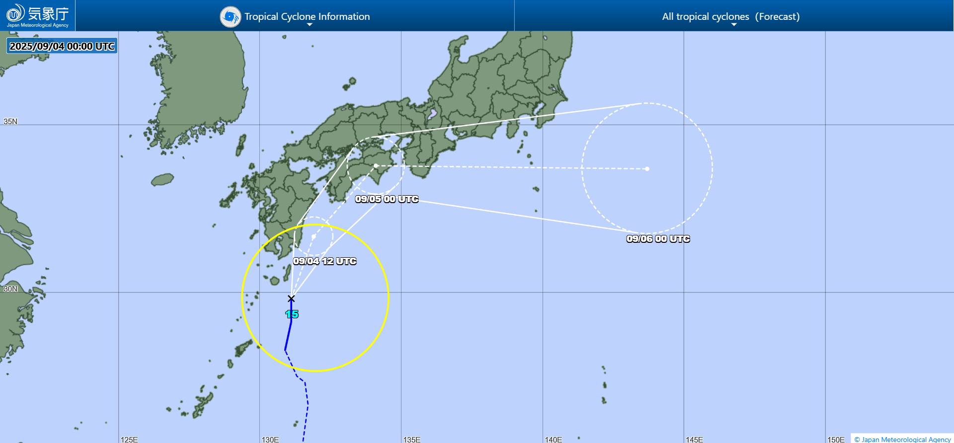
On September 4, the tropical depression strengthened into Typhoon Peipah near the Okinawa Islands (Japan), becoming the 15th storm of the 2025 typhoon season in the West Pacific.
The Taiwan Meteorological Administration (China) CWA and the Japan Meteorological Administration (JMA) both warned of the risk of disruption of flights from Taipei to Japan in the next 2 days.
According to the CWA, at 8:00 a.m. on September 4, the center of Typhoon Peipah was about 1,080 km northeast of Taipei (Taiwan, China), moving at a speed of 26 km/h, towards Kyushu Island (Japan). The storm has the strongest winds of 65 km/h, gusts of 90 km/h, central pressure of 1,002 hPa.
Typhoon Peipah is forecast to sweep across Kyushu, Shikoku and Honshu along the Pacific coast on September 4 and 5, bringing heavy rain, strong winds and the risk of flash floods and landslides.
Towns in Miyazaki Province (Southern Kyushu) experienced heavy rainfall, of which Tsuno Town recorded 71mm in just 1 hour, Miyazaki City 34mm. Extreme rainfall of over 50 mm/h is forecast to continue, increasing the risk of landslides, flooding, river overflow and strong gusts of wind with tornadoes.
The Japan Meteorological Agency warned: At atmospheric conditions are extremely unstable, beware of flash floods and landslides in low-lying mountainous areas, as well as high waves and dangerous tornadoes.
Meanwhile, the weather forecast for today in Taiwan (China) is generally hot and sunny, with temperatures of 32-35 degrees Celsius. In particular, the Hang Xuan peninsula and Kim Mon island will have scattered showers. In the afternoon, the western and eastern mountainous areas are prone to localized thunderstorms, with rainfall exceeding 40 mm/h, accompanied by thunderstorms, gusts of wind and the risk of flash floods.
The CWA recommends that people and tourists closely monitor flight schedules, especially routes between Taipei (Taiwan, China) and Japan, due to the possibility of changes at the last minute.
Peipah marks the 15th storm of the 2025 West Pacific typhoon season, as the region enters the peak of the typhoon and flood season. In just 24 hours, Peipah has strengthened from a tropical depression into a tropical storm, suggesting atmospheric conditions are extremely favorable for strong storm formation.
Experts say that on September 5, the storm will continue to move deep into Japanese territory before changing direction to the east, affecting the Kanto area - where the capital Tokyo is located.